


TECTONOPHYSICS
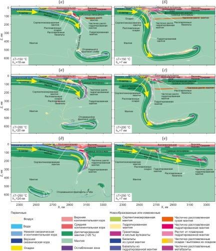
Eclogitization of magmatic rocks in the oceanic crust plays a key role in the mechanism of the lithospheric plate movement. This effect (as well as its kinetic delay) is particularly important in the Precambrian subduction when oceanic crust could be several times thicker than today. This paper presents the results of numerical modeling of the Early Precambrian subduction beneath the continent, at elevated (by ΔT=150–250 °C relative to today’s) mantle potential temperature and different oceanic crustal thicknesses, based on discrete eclogitization of the rocks in the oceanic-crust basaltic and gabbroid layers, as well as on mantle depletion. The modeling has shown for the first time that the oceanic crustal thickness has a profound effect on the Precambrian subduction regime. The thick-crust (18–24 km) models exhibit flat subduction at all values of ΔT. The thin-crust (7 km) models show flat subduction only at ΔT=250 °C, whereas at ΔT=150–200 °C flat subduction is typical only for subduction initiation with a further flat to steep transition in subduction style, accompanied by processes of slab rollback and magmatism at an active margin with the dominance of acid magmatism over basite magmatism. These data imply that the present-day steep (or steep-like) subduction zones could occur in the Early Precambrian where the plates with thin (like today) oceanic crust were subducting.
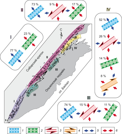
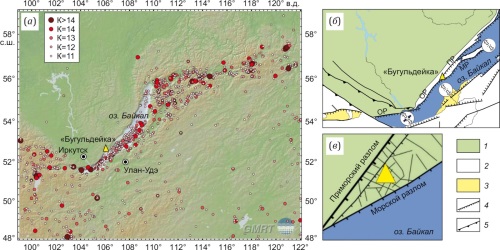
Marginal suture zones of ancient platforms are deep-seated fault zones separating the craton from the mobile belt. Of particular interest is the Pribaikalian marginal suture of the Siberian craton, activated during the Cenozoic rifting. There is one of the youngest structures of the Baikal rift zone – the Buguldeika-Chernorud graben. The graben is formed by the Primorsky and the Tyrgan normal faults, longitudinal relative to the marginal suture. The paper deals with the study of the graben interior structure by the electrical resistivity tomography method and presents the results of tectonic stress reconstruction by different methods. The study has shown that the fault-block structure of the graben and its immediate vicinities formed largely under the northwest to southeast regional extension conditions typical for the Late Cenozoic development of the Baikal rift. Local faults corresponding to other regional dynamic settings make up no more than 26 % of the total amount.
The results of long-term investigations carried out in Kamchatka show that an increase in intensity of geoacoustic radiation and amplification of its anisotropy can be considered as an indicator of deformation process activation during earthquake preparation. One of the main characteristics of the stress-strain state of rocks is the orientation of the principal stress axes, and in particular of the maximum compression axis. The present paper deals with the experimental studies and mathematical modeling performed to detect the relation between the orientation of the axis of maximum compression of rocks and geoacoustic radiation anisotropy during earthquake preparation.
In 2008–2016, using the vector-phase method, an analysis was made of the direction of geoacoustic radiation, recorded at the "Mikizha" site in Kamchatka within a three-day interval before earthquakes. There were detected two main orthogonal maxima of radiation (average azimuths 312.5°±15° and 42.5°±15°), with one of them, in the authors’ opinion, perpendicular to the maximum compression axis.
In an elastic approximation of a medium, modeling has been performed for the orientation of the axis of maximum compression of rocks during the preparation of strong Kamchatka earthquakes in 1976–2020. According to the results, the axis was lying within the sector with the azimuths of 330.5 and 84.2°, the modal interval was 22.5 up to 45.0°, and the average value was 32.7°. The model-based average orientation of the axis of maximum compression agrees with the value determined from experimental observations of geoacoustic radiation at the "Mikizha" site.
The results of the study confirmed the assumption that the direction of geoacoustic radiation maxima occurring during earthquake preparation is determined by the orientation of the axis of maximum compression of rocks at the observation site. The obtained results can be used to study geodeformation process characteristics in seismic regions.
PALEOGEODYNAMICS
Using the Dakhov granitometamorphic block (Neoproterozoic – Paleozoic) as an example consideration is being given to exhumation mechanisms of the Hercynian basement complexes within the epi-platform orogen of the Greater Caucasus. The block forms a horst-like uplift and is located in the junction area between the Central and Western Caucasus segments, where the pericline of the Paleozoic core of the orogen is tectonically overlain by the Cimmerian (Lower to Middle Jurassic) and Alpine (Middle Jurassic to Cenozoic) structural-formational complexes. The geologicalstructural and particularly the structural-kinematic studies have shown that the Dakhov uplift sits in the transpressional dextral strike-slip fault zone that is a branch of the long-lived Pshekish-Tyrnyauz suture zone. The sandstones and shales of the Cimmerian complex commonly found north and south of the Dakhov uplift, are complicated by the nappeoverthrust structures with divergent displacements occurred relative to the axis of Dakhov block uplift and associated with sliding collapse of the overlying Jurassic strata into the adjacent depressions. The Dakhov block itself is a structural element of a shear zone, which forms a shear duplex and participates in the formation of large Z-shaped shear-contact axonoclines complicating the northern part and the eastern pericline of the uplift, as well as its bordering Jurassic strata. The northern part of the uplift still contains a fragment of a serpentinite-gneiss melange zone that formed during the Hercynian tectogenesis. This zone exhibits signs of kinematic inversions in fault structures, related to rotation phenomena of large domains of metamorphic rocks.
The isolation of the Dakhov uplift within the Hercynian basement structure was caused by the presence of a rheologically weakened Hercynian suture zone (serpentinite-gneiss melange) therein. During the Cimmerian dextral slipstrike movements, this zone was reactivated and experienced planar bending, which gave rise to the formation of asymmetric Z-shaped axonoclines. Rotational shear deformations in the area of converging flanks of these axonoclines contributed to the development of an extensional shear duplex, in which the Dakhov crystalline block was uplifted. The Cimmerian exhumation of the Dakhov crystalline block occurred as a result of the combined action of two interconnected heterogeneous processes: transpressional deformation of the basement and gravity sliding of the Lower to Middle Jurassic cover sediments. The processes involved in the Late Alpine orogeny, which began at the Neogene-Quaternary boundary, proceeded simultaneously with the collapse of the growing Greater Caucasus orogen. One of the forms of collapse occurrence in the study area was the development of tectono-gravitational detachments and sliding of the Alpine cover sediment down the northern slope of the orogen that causes the pre-Alpine basement rocks, including the Dakhov crystalline block, to be exposed on the modern relief surface.
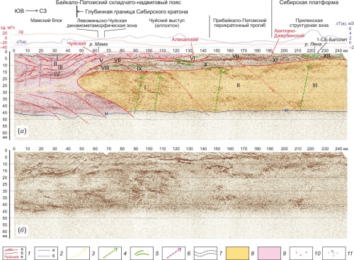
The deep-seated boundary structures of the Siberian craton and the Baikal-Patom fold-and-thrust belt have been considered in the cross-section of the 1-SB-Vostochny reference geophysical profile and its continuation along the Vitim River. The deep crustal CDP seismic reflection profiling, with regard to the distribution of potential fields, made it possible to construct a geodynamic model of the junction zone of the Siberian craton and the Baikal-Patom belt. The model highlights the Siberian craton basement structures, overlain in the marginal part by a complicated series of nappes including the Chuya allochthon, the Baikal-Patom pericratonic trough, and deformed complexes of the sedimentary cover of the craton. There has been the south-easterly increase in the cover thickness from 5 to 15 km, as well as the cover saturation with salts and gabbroid sills. The structures of the folded framing of the craton are represented by the Mama block, the complexes of which surround the wedge-shaped end of the basement of the Siberian craton, splitting from the mid-crustal level. The upper plates of the Mama block, with the 3–4 km thick Chuya allochthon at the base, are thrust over the craton, and the lower plates are thrust under the craton, sinking into the mantle. The southern boundary of the Siberian craton has been traced on the basis of geophysical data complex.
The article presents the results of 40Ar/39Ar dating of rocks (quartz and alkali syenites, nepheline syenites with REE-Nb-Zr mineralization) from the Burpala massif using feldspar, phlogopite, and amphibole. The obtained results limit the closure of the K-Ar isotope system in feldspars of quartz and alkali syenites to 274–283 Ma, while the age of closure of the K-Ar isotope system in amphibole of alkali syenite and in phlogopite of ore-bearing nepheline syenite is 298±4 Ma and 301±4 Ma, respectively. Estimates of the formation pressure using the plagioclase–hornblende geobarometer show that the massif rocks were formed at a depth of about 10 km. Comparison with zircon age values indicates a simultaneous closure of the U-Pb and K-Ar isotope systems in zircons, phlogopite and amphibole, respectively. The closure of the K-Ar isotope system in feldspars occurred 12–15 million years later.
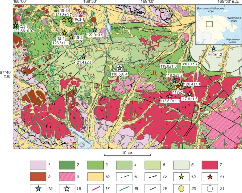
The article presents new data on the isotopic geochronology and geochemistry of magmatic complexes on the northwestern periphery of the Tytylveem Depression, Western Chukotka. U-Pb ages obtained for the emplacement of monzonite stocks of the Chukotka complex (124±1 Ma) and for the onset of effusive activity associated with the flood basaltic andesites of the Tytylveem formation (124±1 Ma) are the oldest known ages of post-collisional magmatism within the Chukotka region. Granitoids of the Chukotka complex are dated for the first time. Dolerites of the Tytylveem subvolcanic complex differ from the host Tytylveem volcanic rocks by lower MgO, higher K contents, and affilation with the oxidized magnetite series. Monzonites of the Chukotka complex and subvolcanic dolerites derive from sources with a higher proportion of depleted mantle component then the younger (122–117 Ma) rocks of the Tytylveem volcano-plutonic belt. Mineralogical and geochemical characteristics of the monzonites indicate that the Chukotka complex magmatic rocks may belong to the core of a porphyry epithermal system that includes the Dvoinoye and Sentyabrskoye deposits.
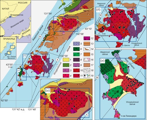
Here are presented the results of the petrophysical studies of granitoid complexes located on the Muravyov-Amursky Peninsula and the Russky and Popov islands. The factual basis of the research was a collection of field samples from the Late Permian and Middle and Late Jurassic granitoid complexes. The determination and analysis have been made on their density and magnetic susceptibility according to the generally accepted methodology. It has been found that the heterogeneous rocks differ sharply in their physical properties mentioned above. The Late Permian granitoids of the Sedanka complex have higher densities and magnetic susceptibilities than the Middle and Late Jurassic granitoids of the insular complex. A relationship has been determined between physical characteristics of the granotoids and their mineral composition and formation conditions. A conclusion has been made that the physical properties may be used as an additional criterion for the material and age-related differentiation of magmatic complexes located on other island and underwater structures of Peter the Great Bay and in its continental coastal zone. Results of the study may be used for interpretation of the geophysical fields in Peter the Great Bay.
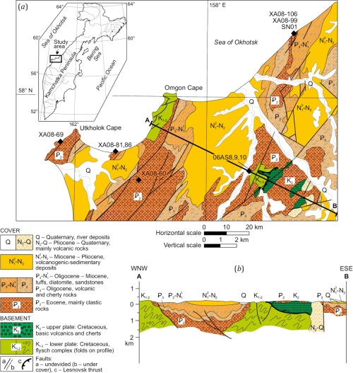
The lithology, composition, U-Pb LA-ICP-MS ages of detrital zircons from sediments of the Western Kamchatka Basin (Russian Far East) provide important insight into paleogeography and tectonic setting of the Sea of Okhotsk in the Eocene. Our study is based on mapping, structural observations, descriptions of the sections and lithology, composition of the sandstones, and U-Pb LA-ICP-MS dating and morphology analysis of detrital zircons from the Eocene sandstones of the Western Kamchatka Basin. The provenance for the sandstones is mainly associated with orogen recycling in magmatic arcs. The analysis of heavy minerals indicates mafic to sialic sources. The mafic terranes of the Asian margin on the west or/and Olyutorka-Kamchatka ensimatic island arc affected the mechanism transferring the basic material to the Western Kamchatka Basin in the Eocene. The sialic clasts originated from continental blocks of the Asian margin and the Okhotsk-Chukotka volcanic belt.
New data allow us to prove that the erosion of the Okhotsk-Chukotka belt had a significant influence on the sedimentation system in the north of the Sea of Okhotsk in the Eocene. We can assume that the Paleo-Penzhina River system already existed in the Eocene. The existence of the sialic sources in Eocene allows us to assume the possibility of finding the good quality collectors in the Eocene deposits of the Western Kamchatka Basin and the north of the Sea of Okhotsk.
RECENT GEODYNAMICS
The parameters of earthquakes recorded in the Arctic region during the early 20th century and calculated by researchers in the first half of the century continue to be used in modern seismic event catalogs. However, these hypocentral parameters are predominantly computed based on bulletins compiled only from a subset of the seismic stations operated during that period, utilizing outdated velocity models and location algorithms, which restricts their accuracy and reliability.
This study presents a consolidated catalog of all earthquakes recorded between 1900 and 1950 within the geographic region bounded by 70.0° to 90.0° N latitude and 70.0° E to 170.0° W longitude. Using the most comprehensive set of instrumental data, a modern velocity model, and a location algorithm adapted for early instrumental earthquakes, a refined catalog of earthquakes was compiled for the eastern sector of the Russian Arctic during the first half of the 20th century. Additionally, a secondary catalog was developed for earthquakes attributed to the region in various sources. However, after recalculating the epicentral coordinates, these events were excluded from the considered area. A total of 19 earthquakes were recorded within the study area, with magnitudes (Mw) ranging from 5.2 to 6.9, primarily associated with the Gakkel Ridge and its continuation on the Laptev Sea shelf, as well as the continental portion of northern Yakutia. The results of this study can be used to refine seismic regime parameters, develop geodynamic models, and investigate the stress–strain state of the Earth’s crust. Furthermore, these results may be applied to address safety concerns in the operation of industrial systems and facilities during the exploration of major deposits in the eastern sector of the Russian Arctic.
The paper deals with the monitoring-based determination of spectral composition of microseismic noise (MSN) several hours before weak and moderate seismic events in the Baikal rift system. Consideration is being given to 40 earthquakes with an energy class of K=9.5–14.5 at 10 to 120 km distances from the epicenters to the monitoring sites. It has been found that the change in spectral composition of MSN is statistically significant compared to background values. The frequency range of 0.5–2.5 Hz exhibits an increase in power spectral density, whereas higher frequencies, approximately 4 to 16 Hz, show its decrease. Machine learning methods were used to construct a binary classification model regarding the records of MSN whose spectral composition allows detecting the occurrence of short-term earthquake precursors. The studies were based on the digital platform (https://izk.sscc.ru). Seismic data is received at the digital platform from integrated monitoring of hazardous geological processes at the sites of the Institute of the Earth’s Crust SB RAS, Irkutsk.
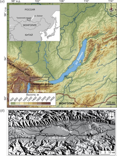
Sediments in the Tunka rift valley are deposited in high-energy geomorphic and lithodynamic processes. A number of Paleolithic sites are located here, but the number of archaeological finds in different parts of the rift varies greatly. The aim of this study was to reconstruct the features of exogeodynamics and the sedimentation environments in the Tunka valley to explain the reasons for the different degree of preservation and spatial distribution of archaeological material from the Upper Paleolithic sites and to assess the potential of sites for the discovery of cultural horizons in situ. Based on the petromagnetic and granulometric analyses of the samples (923), a study has been made on 6 sections, similar in age and different in geological structure, thickness, and geomorphological position. All sections are 14C and TL dated. The integration of granulometric and petromagnetic data helps to reconstruct different sedimentation conditions in the explored sites of the Tunka depression and to estimate their suitability for prehistoric human habitation.
The Belyi Yar I and Belyi Yar II section are characterized by high sedimentation rates and a large influx of loose sedimentary material due to catastrophic floods and other processes. High sedimentation rates were also reconstructed for the Shimki section (where archeological discoveries have not yet been made), but the presence of paleosoil horizons indicates milder environmental conditions. The Tuyana site, located highest relative to the bottom, contains numerous archaeological finds. This is due to low sedimentary input, well-developed buried soils, and a lack of signs indicating catastrophic floods. The Zaktui site, located hypsometrically lower than the Tuyana site, is less suitable for preservation of culture-containing horizons. An intermediate position is occupied by the Slavin Yar section.
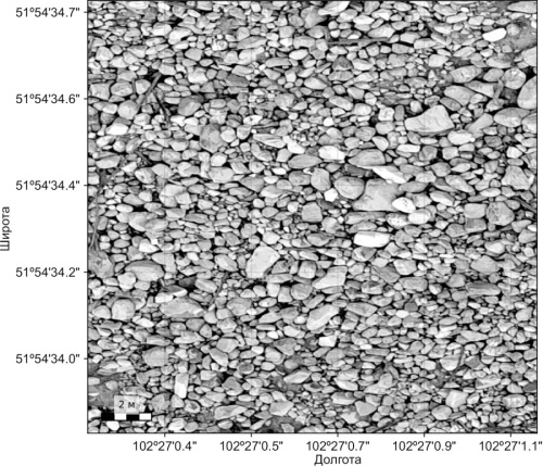
This study is devoted to automation of the assessment of the dimensional structure of coarse-grained material on orthophotomaps obtained from unmanned aerial vehicles (UAVs). Orthomosaics with a Ground Sample Distance (GSD) of ~2–4 cm were used on the material of ten debris-flow deposits of the Baikal region; an annotated dataset was prepared in SedimentAlyzer. The algorithm combines object detection by computer vision methods with subsequent classification and Feret diameter estimation using convolutional neural networks (CNN; architectures: residual convolutional network (ResNet) and densely connected convolutional network (DenseNet), transfer learning). The output is performed on overlapping cells; preliminary determinations are merged (non-maximum suppression, NMS / weighted boxes fusion, WBF), probabilities are calibrated (temperature scaling) and shape filters are applied. The implementation is integrated into SedimentAlyzer. The software is registered (state registration certificate for computer program No. 2025616929). The following values were achieved in the retained areas: F1-score = 0.84±0.03; mean absolute Feret error = 4.8 cm; RMSE=7.9 cm; correlation with field measurements R=0.89; agreement with GOST size classes averaged 82 % across basins. Compared to manual interpretation, labor time is reduced by a factor of 6–8. Typical patterns include dominance of clasts 10–100 cm (≈30–40 %) and a variable share of boulders >200 cm (1–13 % with maxima in small tributaries); in transit zones, the proportion of very large fragments is higher than in accumulation zones. The approach enables reproducible mapping of fractions and is suitable for regular monitoring of debris-flow cones and support of engineering decisions.


