PALEOGEODYNAMICS
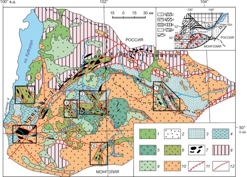
The Dzhidot and Urgol large paleoguyots and a number of smaller fragments of oceanic islands close in composition to the paleoguyots within the accretionary-collisional structures of the north-eastern part of the Central Asian orogenic belt are distinguished and described. Paleoguyots and their fragments form separate blocks of the oceanic crust in tectonic mélange as a part of large allochthons. Formation of paleoguyots occurred predominantly in the Ediacaran – beginning of the Early Cambrian in the oceanic environment under the influence of hot spots (mantle plumes). The oceanic crust containing paleogayots was subducted beneath the Dzhida island arc. The formation of the Dzhida paleoguyots and island arc took place at the same time intervas as similar formations of the Bayankhongor and Ozernaya zones of Western, Central Mongolia, East Tuva and Gorny Altay zones the Altay-Sayan region of the Central Asian Fold Belt.
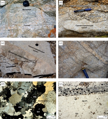
This study integrates the isotope-geochronological (zircon U-Pb dating), petrogeochemical and structural-petrological data, as well as the data on garnet composition and fluid inclusions in leucogranite quartz, to characterize S-type granitoid magmatism on the margin of the Tuva-Mongolian massif (Western Sangilen, Southeastern Tuva). The S-type granites form small garnet-, garnet-cordierite-bearing granite and leucogranite vein bodies. Their formation occurred during two stages of tectono-magmatic activity. The first stage (517±3 Ma) relates to the initiation of a tectonic zone and is characterized by migmatization and garnet-cordierite granite formation at T=730–790 °C and P=5.3 kbar. The second stage (490–483 Ma) of local extension involved repeated heating to ~680 °C, which led to rheomorphism of the Early Cambrian migmatite-granites. The leucogranite veins (480±6 Ma) represent neosomes of migmatites, formed at T=760–830 °C via low-degree melting (<20 %) of cordierite-garnet-biotite migmatites.
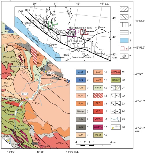
New data have been obtained on the U-Pb LA-ICP-MS age of detrital zircons from the Middle-Late Carboniferous and Early-Middle Permian molasses of the Greater Caucasus. The accumulation of molasses in the Carboniferous was associated with multiple-age clastic removal. The Permian was dominated by the source areas of detrital zircons with the narrow age range. According to the results obtained, the Kinyrchad formation dates back to the Ufimian (Early Permian). An ancient population of detrital zircons in the Early-Middle Silurian Ullu-Lakhran formation indicates the presence of blocks of ancient continental crust or products of erosion of the blocks within the feeding province. Analysis of the obtained isotopic data on the ages of zircons from the Bechasyn metamorphic complex and detrital zircons from the molasses of the Peredovoy Range zone and the Bechasyn zone testifies in favor of the peri-Gondwanan origin of the complexes making up the metamorphic basement of these zones and their formation on the Gondwana margin at the end of the Late Riphean – Vendian. U-Pb dating of zircons from the Albian-aged (102±1 Ma, ±1σ) andesibasalts of the Daut River valley raises the question of the probability of manifestation of the Cretaceous magmatic activity in the Greater Caucasus.
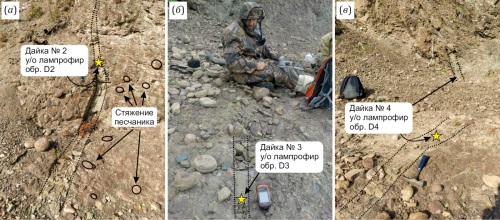
This work studies thin ultramafic lamprophyre (UML) dikes associated with the Tomtor alkaline-ultramafic massif (Arctic Siberia). 40Ar/39Ar dating yielded an emplacement age of 710 Ma for the dikes. U-Pb dating of calcite indicates a 400 Ma year old low-temperature recrystallization event. Both age constraints correlate with some notable phases of Tomtor magmatism. The dike locations 15 km away from the main massif suggest a more extensive magmatic province than previously thought. The spatial association of the dikes with the Mesoproterozoic Udzha paleorift highlights the crucial role of inherited tectonic structures in controlling over magmatism. It is probable that the formation of both the dikes and the Tomtor massif was governed by two key factors: (1) favorable lithospheric setting due to the location at the junction of the Archean Daldyn terrane and Paleoproterozoic Khapchan orogenic belt, which is responsible for the localization of the Udzha paleorift; and (2) the reorganization of tectonic stresses within the northern Siberian Craton during the Neoproterozoic and Devonian. The magmatic and consequent recrystallization stages (710 and 400 Ma, respectively) identified within the Udzha paleorift, correspond to major regional geodynamic events, such as Neoproterozoic tectonic convergence in Central Taimyr and Devonian rifting (Vilyui rift system).
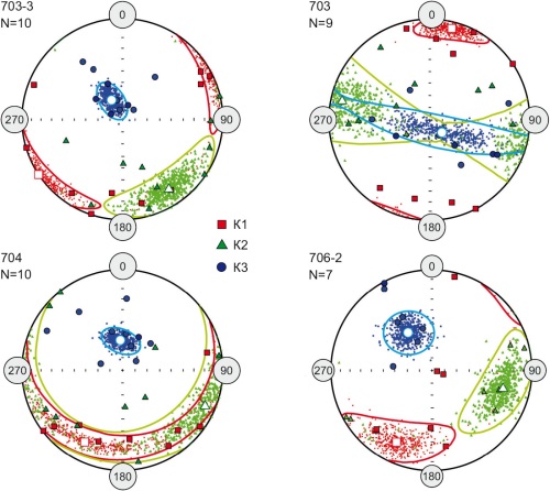
A series of articles presents isotopic and palaeomagnetic data for rocks of the Early Carboniferous Berezovka complex of the Magnitogorsk zone. The study had a twofold objective: firstly, to obtain the first isotopic ages and, secondly, to carry out geodynamic reconstructions for the time of formation of the complex based on palaeomagnetic data.
This paper presents the first rock magnetic and palaeomagnetic data for volcanic rocks from the Early Carboniferous Berezovka volcanic complex in the Magnitogorsk zone (Southern Urals). It can be concluded from the rock magnetic data that the studied rocks have not undergone significant secondary alteration and have retained their pre-folding magnetization. Palaeomagnetic poles, calculated from the directions of pre-folding magnetization, made it possible to propose a new kinematic model for the Magnitogorsk-Bogdanovka graben based on shear deformations in the Karabulak reverse-slip zone.
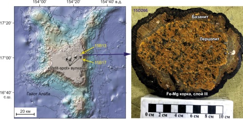
The index-species of calcareous nannoplankton in two cored wells, penetrating the Miocene rocks of the Alba Guyot, have been used to identify time intervals for deposition of the young (Pleistocene-to-modern, <1.8–0.2 Ma) Fe-Mn crust from Unit III in the complete section of the Magellan Seamounts Fe-Mn crusts, Late Miocene (>7–13 Ma) basanite tuff, tuffite sublayer (<5.6–7.0 Ma), as well as the ancient crust and buried nodules formed prior to the Early Miocene – Late Oligocene (>18–24 Ma). There have been discovered young Fe-Mn crust sublayers of contrasting composition and growth rate: early, enriched in Mn, Ni, Cu, Nb, and late, substantially ferruginous, with high REE, Y, Be, Sc, V, Zn, Rb, Cs, Sr, Zr, Hf, Mo, Sb, Pb, Th and U contents.
Disregarding the duration of a probable break in the deposition of ore matter (Fe-Mn oxyhydroxides), the young crust with a Co-chronometry-based thickness of ~4 mm was formed over a period of ~2.3 Ma with an average growth rate from 1.6 mm/Ma in the early sublayer to 2.2 mm/Ma in the late sublayer. A young Fe-Mn crust 4–8 mm thick began to form on Miocene rocks 4.5 to 2.3 Myr, when the guyot surface was at depths below the oxygen minimum zone in the ocean water column (>600–700 m). A contrasting change in the composition of the late sublayer (a significant increase in Fe, REE, Y, V, Zn, Sr, Zr, Hf, Mo, Sb, Pb, Th and U contents) could have been caused by a 500000-year-old rapid subsidence of the guyot to depths similar to present-day (1250–1500 m at the plateau level). The average Co concentration (0.8–1.0 wt. %) in the young Fe-Mn crust on Miocene rocks is almost twice that of the bulk composition of thick (multilayered) crusts in other parts of the guyot. Relatively small-scale distribution of the young Fe-Mn crust, anomalously enriched in Co, will apparently have an insignificant impact on the increase in inferred ore reserves on the Alba Guyot for this strategically important metal.
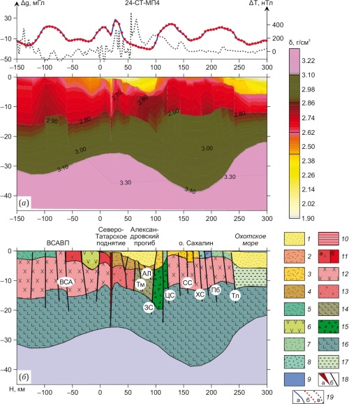
The paper presents the results of structural-density modeling of the southern and northern Tatar trough, performed in order to detail the features of the deep structure of the Earth’s crust and to detect hidden tectonics of the transition zone between the South Tatar and North Tatar basins. Maps have been compiled for the Moho surface relief and density distribution in the basement of the South Tatar and North Tatar basins, on the basis of which a conclusion is made about the south-north alternation of the Earth’s crust types and the existence of an interbasinal subcontinental block between these two basins.
RECENT GEODYNAMICS
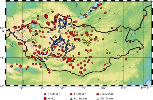
Adjusting the local magnitude scale to match the regional tectonic characteristics is crucial to enhance studies focused on evaluating seismic risk and measuring seismic activity in geologically dynamic zones. In this study, we developed a local magnitude scale for Mongolia. Using the Mongolia earthquake catalog for the period from 2012 to 2019, we analyzed 261 earthquakes with magnitudes ˃3.5 that occurred within a 1000 km epicentral distance and were recorded by at least five broadband stations. The compiled data set includes 8616 horizontal peak amplitude measurements from 144 broadband stations.
We performed a detailed linear regression analysis to develop the local magnitude formula in accordance with the guidelines of the International Association of Seismology and Physics of the Earth’s Interior. As a result, the new local magnitude formula is expressed as: ML=log10(A)+0.9287log10(R)+0.0012R−1.66. In addition, we determined the correction factors S for each station.
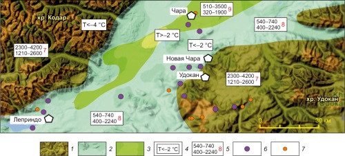
The paper considers the problem of the geological and geophysical data systematization, the importance of which is related to new solution conditions both in fundamental and applied aspects. Particularly important is the opportunity to study the influence of geological section on the level of manifestation of seismic loose and rocky material properties. The structure of geophysical fields has been studied using the systems which include the combinations of mountain and lowland regions. The basic parameters have been obtained during the engineering survey of the segments of the Chara, Muya and Tunka basins.
The initial data have been obtained as a result of integrated geophysical measurements (seismic survey, electrical survey, microseism recordings and theoretical calculations). The fundamental factor is the presence of frozen ground.
TECTONOPHYSICS
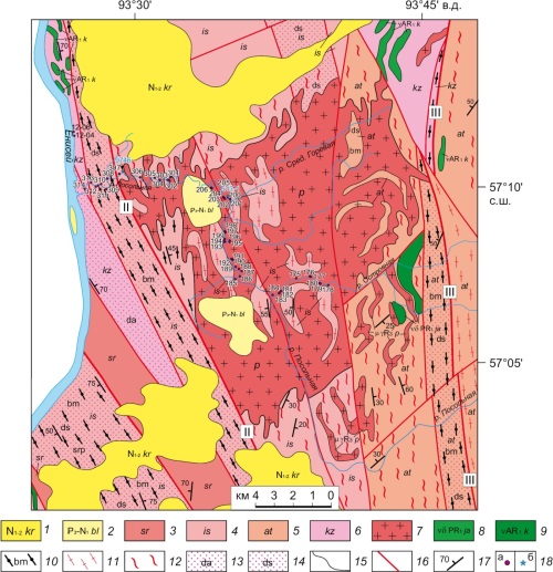
The paper presents the results of 3D numerical thermomechanical modeling of the formation mechanism for the Posolnaya massif of granitoids in the Posolnaya-Kuzeeva tectonic zone of the South Yenisei Ridge. A mathematical numerical model has been proposed for the massif formation due to heat dissipation during shear deformations in the Posolnaya-Kuzeeva tectonic zone. The modeling was carried out in a 3D formulation by solving the Navier-Stokes equations using the ANSYS Fluent software package. Versions of the structural model of the Posolnaya-Kuzeeva tectonic zone have been considered in relation to the width of an active horizontal shear zone and composition of the crustal rocks (metamorphic protolith) from the tectonic zone. The model of dissipative heating and melting in a 20 km-wide shear zone reproduces the actually observed shape of the Posolnaya massif. The dependence between the height of magma ascent and the rheological properties of crustal rocks has been determined. It has been shown that dissipative heat release during the deformation of rocks, exhibiting the rheological properties of wet granite, results in melting and diapiric ascent of felsic magma from the base of the granite-gneiss layer (45 km) to a depth of 9–11 km. In a crustal model described by the rheological properties of felsic granulite, melting occurs "in situ" in a larger volume, but without further ascent of the magmatic mass. Shear rate is shown to be a key parameter for the efficiency of dissipative heating. A threshold shear rate for the most efficient melting and magmatism under dissipative conditions has been estimated at 4 cm/yr (and higher).