


PALEOGEODYNAMICS
The paper presents the first results of U-Pb LA-ICP-MS isotope dating (GIN RAS) of accessory zircon from magmatites of the Kastel Mountain and detrital zircons from the sandy matrix of conglomerates of the lower subformation of the Demerdzhi formation (vicinity of the Southern Demerdzhi Mountain). The three age estimates – (±1σ) – 147±1, 156±1 and 167±1 Ma, – obtained for granitoids of the Kastel intrusive, are consistent with the concept of its longterm and multi-stage magmatic evolution. The age of 167±1 Ma coincides with the final stages of the episode of bimodal magmatism widespread throughout the Mountainous Crimea from the Cape Fiolent to the Karadag. The intrusion of the first portions of basic magma near this time boundary had initiated the Kastel intrusion formation. The fractionation of basic magma during the second stage about 156±1 Ma gave rise to the formation of silicic melts from which the plagiogranites, comprising most of Kastel intrusive, were crystallized. About 147±1 Ma, the residual portions of silicic melts as small aplite veins intervened in the main volume of the intrusive and the adjacent host rocks.
A comparison was made of the currently known ages of magmatites and detrital zircons from sandy rocks of some of the Triassic-Jurassic sedimentary strata of the Mountainous Crimes in order to clarify the source areas of the materials constituting the stratified rocks. It was shown that the magmatites of Kastel Mountain were a local source for the Demerdzhi formation.

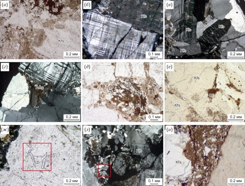
The paper presents data on the geological position, age and features of the material composition of the Saram massif granitoids, located in the northwestern part of the Malkhan ridge of Western Transbaikalia. The structure of the massif involves two-phase rocks corresponding to syenite, early-phase moderate-alkali granite and late-phase leucogranite families. The silica content (wt. %) varies from 63.8 to 71.2 in the early-phase granitoids and from 73.2 to 77.1 in the late phases. The early-to-late-phase rocks of the massif are mostly ferruginous (Fe*=0.77–0.88 and 0.80–0.93, respectively). Based on a high modified alkaline lime index (MALI) (8.75–9.97) and relatively low SiO2 contents, the early-phase rocks can be referred to as alkaline rocks, and the late-phase rocks – as calc-alkaline rocks. According to the aluminum saturation index, the early-phase rocks (0.93–1.07) correspond to moderate-to-high-alumina rocks, and the late-phase rocks (1.09–1.13) – to high-alumina formations. Granitoids are geochemically and mineralogically different from typical agpaitic A-type granites and correspond to a special group of aluminous A-type rocks. The two phase magmatic zircon U-Pb dating yielded the 175–177 Ma age (Early Jurassic). The formation of granitoids in the Saram massif is temporally synchronous with intensive orogenesis in Transbaikalia, probably caused by the closure of the Mongol-Okhotsk Ocean.
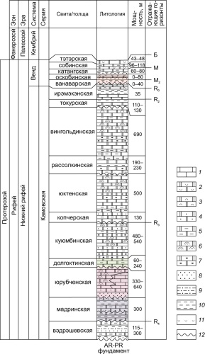
The paper presents the results of the integrated study of the features of geological structure of the southeastern Kamo arch of the Baikit anticlise. Use has been made of both already published and unpublished geological-geophysical data obtained through seismic survey using the common depth point (CDP 2D) and the side view seismic location (SVSL) methods. The conducted research made it possible to improve understanding of the geological structure and formation conditions of the terrigenous-carbonate rocks of the Lower Riphean (Madrа, Yurubchen and Dolgokit formations) and Vendian (Vanavara and Oskoba formations) Kamo Group in the southern Kamo arch of the Baykit anticlese in terms of the prospects for the discovery of hydrocarbon (HC) deposits therein. The interpretation of seismic data (CDP and SVSL) provided the possibility to specify the thickness of the Lower Riphean terrigenous-carbonate rocks, most promising for hydrocarbons, to generate the predictive geology map of the pre-Vendian erosion surface, and to map the HC-promising Early Riphean and Vendian deposit thickness. Along with the previously explored large HC deposits in the central Kamo arch of the Baykit anticlise, the new data presented here testify in favor of the structural-and tectonic conditions for the development of the Lower Riphean and Vendian rocks on the southeastern slope of the Kamo arch of the Baykit anticlise and imply their high potential.
The paper describes the petrographic and petro-geochemical composition of granitoids of the Khotugu-Eyekit massif and the rhyolite dike of the Sololi uplift. It was revealed that the rocks of the massif are represented by microcline granites. The massif is monotonous in composition, i.e. it does not exhibit any facies transitions or differences in intrusion phases. In addition to the massif rocks, the study area is characterized by a widespread occurrence of small bodies of rhyolite dike rocks that have been strongly altered by secondary processes. An assumption was made about the pre-granitoid origin of these dikes and their intensive post-magmatic alteration. Based on the content of basic petrooxides, its ratios and relationships, as well as indicator petrochemical coefficients, it was concluded that the rocks of the Khotugu-Eyekit massif are most similar to the A2-type plumasite granites of the high-potassium calc-alkaline petrochemical series. The main geochemical criteria indicate the dual nature of the granites of the Khotugu-Eyekit massif, which are similar to the granitoids of the collisional formation setting of the area, and their petrogenesis is apparently associated with both mixed crust-mantle and purely crustal source. The same compositional parameters suggest that the rhyolite dike belongs to low-alkaline formations of the tholeiitic series, corresponding to those of the plumasite rare metal series of the crustal nature. The U-Pb dating yielded an absolute age of 2146±13 Ma for the rhyolite dikes; the same method and the geological data imply that the Khotugu-Eyekit massif is Mesozoic in age, dating back to 186.7–157.2 Ma. Mineragenic specialization analysis of the Khotugu-Eyekit massif and the rhyolite dike, performed on the basis of the geochemical data, allows classifying the studied formations as productive in terms of gold-bearing ore formations.
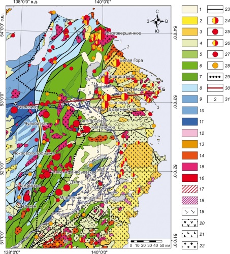
The density and magnetic models of the Earth’s crust and lithospheric mantle were developed for the Lower Amur River gold-bearing area. Geological and geodynamical interpretations were made of the deep-seated inhomogeneities found there. It has been shown that the main differentiation of regional geophysical fields in the area is related to the subcrustal mantle inhomogeneities and magmatic bodies in the middle and upper crusts. These inhomogeneities resulted from the Late Cretaceous – Cenozoic magmatic processes occurring in this segment of the Paleoasian margin under subduction conditions, in the mode of strike-slip margin or continental rifting.
The spatial relationship was shown between the epithermal gold deposits and some of the deep-seated structural features of the area. Consideration was given to the role of the mantle density boundaries and up to 20 km deep density inhomogeneities in the gold mineralization distribution. There were identified zones of development of deep-seated magmatic bodies which can be interpreted as basaltic intrusions tracing the inferred deep-seated magma-controlling faults, to which, in its turn, gold mineralization can be related.
RECENT GEODYNAMICS
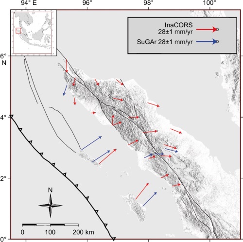
The 2004 M9.2 Sumatra-Andaman earthquake in the tectonically active northern Sumatra, could generate postseismic deformation up to a recent period and needs to be considered for earthquake potential study. The GNSS velocities before and 15 years after the earthquake were used to obtain preliminary indicator of whether the postseismic deformation still takes place. Recent velocities were calculated from the horizontal coordinate time series that is obtained using Bernese GNSS software version 5.2. To do this, a comparison was made of velocities and strain rates over two periods. The velocities of 5.5 to 40.5 mm/yr and the strain rate up to 47.2 μstrain/yr were obtained from the recently acquired GNSS data. The pattern for the two-period values can be defined where the direction of vector velocities is trenchward, and extensional behavior occurs more often in the northern area. This indicates that postseismic deformation still occurs therein even 15 years after the earthquake.
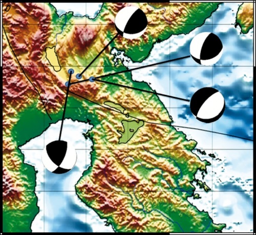
Southeast and Central Sulawesi are the areas characterized by high tectonic activity due to the presence of the active Matano fault. The seismicity along this fault is high. However, the initial hypocenter often deviates from the fault’s trend line, thus causing the need for earthquake relocation with an improved local structure description. The double difference method stands out as a precise technique for hypocenter relocation, utilizing the data on relative travel time between hypocenter pairs. After relocation, the selected hypocenter facilitates the derivation of a focal mechanism, crucial in determining fault types. In this research, we relocated the hypocenters of 485 events of January 2009 to December 2016, ranging in magnitude from M2 to M6.1, 427 of which showed a pattern close to the general trend of major and minor faults. Seismic offsets along the Matano fault are predominantly oriented in the southeast or northwest direction. Moreover, most of the earthquake activity recorded at a depth of 10 km before relocation is no longer visible. Based on the statistics, the time residuals from –2.5 to +2.5 ms resulting from the relocation procedure are better close to 0 than those of –4.5 to +4.5 ms for the events before relocation. The focal mechanism solutions of 16 events of final relocation are dominated by strike-slip faulting. The Matano fault is predominantly sinistral-type. The seismicity along this fault zone results from an activity of this fault, which is the main source of earthquakes, and from its interaction with the neighboring Palu-Koro and Sorong faults.
The southern part of Eastern Siberia and the northern part of Mongolia were quantitatively assessed in terms of the influence of the upper-crustal heterogeneous-velocity ground layers on a single reasonable initial signal. Seismically, the territory is estimated at 7–9 intensity units; geomorphologically, it appears as a system of intermountain depressions and mountain structures; geologically, the area is a part of the Baikal rift zone system as its southwestern and southern fragments are incorporated therein.
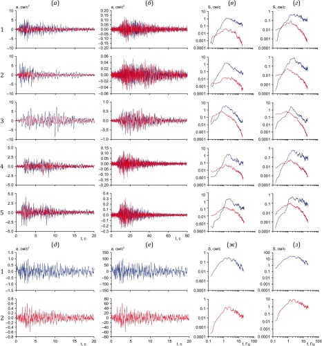
The work is aimed at developing methods for studying and predicting seismic effects of large earthquakes in the Mongolian-Baikal region. The implementation of the task is associated with the need of assigning calculated accelerograms, modeling seismic ground motion, and carrying out theoretical calculations for the region under study. Using the data from 2020-2022 relatively large earthquakes recorded simultaneously in Irkutsk and Ulaanbaatar, I category grounds were assigned a single initial signal with regard to potential source zones of near and distant large earthquakes in the region. Computational models of seismic ground motions were developed based on recently obtained seismic survey and seismometric measurement data. The authors also took into account the available general dataset on the change in seismic wave velocities with depth for the most common types of loose unsaturated grounds to a few hundred meters and for the bedrock to the probable depth of earthquake occurrence. The constructed models are characterized by layer thickness, change in longitudinal and transverse wave velocities with depth, volumetric mass, and attenuation decrement.
The results of theoretical calculations for the features of the influence of heterogenous-velocity ground layers on the amplitude and frequency composition of the assigned initial signals are presented as the parameters of seismic effects (maximum accelerations, predominant ground motions frequencies and their corresponding amplitude level, resonant frequencies and accompanying ground motions amplification values) for seismic probability models developed based on the calculated accelerograms, spectra, and frequency characteristics.
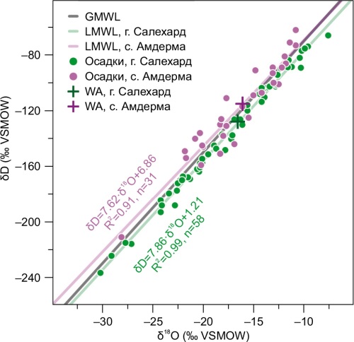
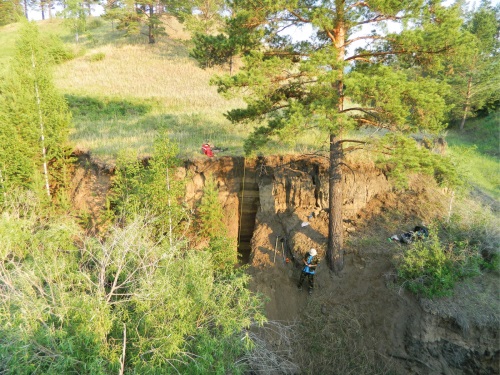
Ice mounds are widespread cryogenic landforms that occur during freezing of water-saturated sediments and in ice segregation or ice injection with the formation of ice cores. Complex mechanisms of occurrence of these landforms have their own characteristics depending on the type of enclosing sediments, water and gas saturation, freezing rate, and other factors. Ice formation processes are often accompanied by explosions of the central part with the occurrence of negative landforms. In response to the widespread occurrence of perennially frozen gas-saturated rocks, these processes are accompanied by gas emissions, gas inflammation. and other, less intense gas shows. It is quite difficult in these conditions to determine the causes of the catastrophic phenomenon, to reconstruct the dynamics of the process, and to understand the role of gas-saturated fluids. In this paper, an attempt has been made to determine the ice formation conditions using isotopic techniques. The isotopic composition of ice can reflect the conditions of ice formation at the time of occurrence of ice mounds and its related possibility of participation of gas-saturated fluids from deep-lying gas-bearing horizons [Buddo et al., 2023, 2024]. The composition of stable isotopes δD and δ18O was determined for three ice mounds in the south of the Yamal Peninsula, where there were catastrophic explosions of ice mounds with the formation of large craters. The results of the study made it possible to reconstruct the conditions of ice mound occurrence and to determine different ice formation modes.
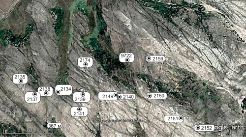
The structure, composition and cut and fill sequence of the Late Glacial and Holocene erosional landforms in the Kuitunka River basin on the right bank of the Selenga River were studied based on a detailed analysis and radiocarbon dating of the soil-sedimentary sequence in the Studenyi Klyuch 2 and Kovalev Pad’ sections. A correlation was carried out between seven sections in the intermittent stream valleys in the Kuitunka River basin. There are three episodes of the Late Glacial and Holocene cutting dated back to ~18–17, ~14.7–14.3, and 0.25–0 cal. kyr BP (ka BP). There are distinguished the periods of colluvial, colluvial-deluvial and aeolian-deluvial sediment deposition in the intermittent stream valleys (17.0–14.7 ka BP) and predominantly aeolian-deluvial loess-like sediment accumulation involving pedogenetic stages (14.30–0.25 ka BP). The climatic warming and humidification led to a decrease in sedimentation rate, prevalence of loessification processes in formation of loess-like deposits, and formation of organic–accumulative soil horizons of different thicknesses. The Late Glacial warming, comparable to the Bølling – Allerød Interstadial (14.3–12.9 ka BP) and the Holocene (11.7–0 ka BP), is characterized by a dynamic change in the stages of loess-like deposit accumulation and pedogenesis. The Younger Dryas cooling (12.9–11.7 ka BP) is associated with the activation of aeolian and cryogenic processes and a short phase of pedogenesis. It was revealed that the most frequent changes in sedimentary phases and soil formation occurred during the Late Glacial Interstadial and the Early (11.7–8.2 ka BP) Holocene. The Middle Holocene (8.2–4.2 ka BP) is characterized by a decrease in the rate of accumulation of intermittent-stream valley loess-like bottom deposits and a long-term (several ka) active pedogenetic process. The cross-sections of the Late Holocene (last 4.2 ka BP) draws and valley-bottom gullies exhibit the stages of pedogenesis (4.2–1.0 ka BP), activation of erosion–accumulation processes (1.00–0.25 ka), gullying, accelerated erosion, and accumulation (last 0.25 ka BP).
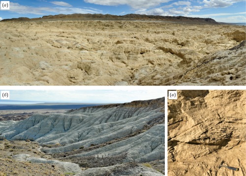
The Great Lakes Depression in northwestern Mongolia contains widespread Late Neogene continental deposits, reaching thicknesses of several hundred metres. The Late Neogene Khyargas Nuur formation (also known as the Khirgis-Nur formation) has a significant biostratigraphic value for Central Asia, as it encompasses a unique palaeontological record and has a wide geographical distribution in the region. The stratotype of this formation was described in the Khyargas Nuur 2 (=Khirgis-Nur-2) section on the northern shore of Khyargas Lake. Bio- and magnetostratigraphic studies conducted in the 1970s and 1980s identified the Miocene-Pliocene boundary (corresponding to the Turolian and Ruscinian biochrons) within Unit A, or the Lower Khyargas Nuur subformation. This study aims to refine the age and stratigraphic subdivisions of the Khyargas Nuur formation in light of new data. Examination of the geology of the Lower Khyargas Nuur Subformation stratotype, along with a revision of the associated mammalian assemblage (carnivores, ungulates, and rodents), supports the conclusion that this faunal complex corresponds to the Late Turolian (MN13) of the continental biochronological scale, thus assigning this section to the terminal Miocene. These findings provide new insights into the geological history of the Great Lakes Depression and the faunal history of Central Asia.
TECTONOPHYSICS
The Cheka pluton, located in the Magnitogorsk megazone of the Southern Urals and composed of the alkaline granitoids, is meridionally elongated (1–2)×6.5 km. The fracture and anisotropy of magnetic susceptibility analysis was made on the Cheka pluton for the first time. The study materials comprise fracture measurements and core samples. The fractures were classified as either prototectonic or tectonic using the Stereonet software. The prototectonic fractures were classified into three standard types in accordance with the system proposed by G. Cloos: S, Q, and L. The system of tectonic fractures corresponds to the Riedel model, which confirms the formation of the pluton as a dextral magmatic strike-slip duplex supposed earlier. The analysis of magnetic mineralogy revealed that the most prevalent magnetic mineral is fine- to-medium-grained magnetite. Using the anisotropy of magnetic susceptibility data, the main direction of melt flow during the formation of the pluton was determined to be 36° NE. This direction is in close alignment with the orientation of one of the prototectonic fracture systems, which has a strike azimuth of 39° NE. The constructed complex structure model indicates that the Triassic granitoid plutons of the Magnitogorsk megazone were most likely formed during the right-lateral transpression, associated with a local strike-slip fault-related extension zone. These conditions are generally consistent with the Triassic rifting and dextral strike-slip motion in the Southern Urals.
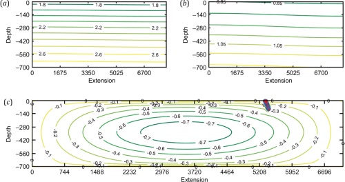
The article provides a review of modern models of large-scale mantle convection in the zone of a heavy cold oceanic plate (slab) subduction into the upper mantle. The formal approximation of the upper mantle for the present case is an incompressible Newtonian fluid with variable viscosity. It is assumed that the plate subduction is preceded by the stage of regime formation for thermo-gravitational convection in the mantle, which is caused by temperature and buoyancy of the lightweight hot substance. Important in this situation is the problem of quantitative formal modeling of phase transitions in the plate itself, as a result of which it becomes compacted due to thermal compression, removal of a part of lightweight mobile components of its original sediments and, consequently, overall weighting of the residual components of its material. It is also important to take into account the impact of mantle currents on the plate, which leads to its geometric distortion. Emphasis should also be placed on representing this plate/slab as an object of numerical modeling, since in the case of its representation as a thin elastic plate, adopted by Gustav Kirchhoff, the current hypotheses of normal remaining normal to the deformed middle surface of the plate and an unchanging thickness are violated.
The aim of the work is to construct a large-scale 2D numerical model of mantle convection in the subduction zone, which takes into account the thermal gravity regime for the upper mantle and the plate, initiated by plate subduction, the influence thereon of mantle flows (mantle wind), and phase transitions in the plate. Based on smoothed particles hydrodynamics (SPH), there was constructed a computational scheme of the slab dynamics. To verify the model, there have been performed a number of computational experiments, the results of which are generally consistent with the seismotomographically identified structure of mantle flows in the subduction zone. Thus, the model appears to show fragmentary nature of the process of subduction being due to the interaction between the subducting plate and the part that remains on the surface, which leads to deformation of the descending plate.


