


PALEOGEODYNAMICS
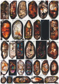
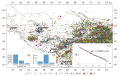
The paper presents the results of U-Pb isotope dating of zircons extracted from rocks of the southern part of the Baltic Shield (Early Riphean conglomerates and Paleoproterozoic secondary quartzites) and makes a comparison of these results with the ages of crystalline complexes of the East European Platform (EEP). The paper presents the study results on composition of quartzites from the Bol. Tyuters and Gogland islands. There has been discussion about tectonic and paleogeographical features in the period prior to the beginning of Riphean sedimentation in the northeastern part of the EEP. It is concluded that the conglomerates are composed of erosional products of mainly Paleoproterozoic and less frequently Archean crystalline complexes. At the same time, the rocks at the base of the generalized section of Riphean deposits (Gogland group), did not contain any zircons with ages referring to 200 million years prior to the inferred time (1640–1660 Ma) of the beginning of the conglomerate sequence formation. The rocks that compose the Gogland group and their underlying Paleoproterozoic basement rocks have significant differences. We associate these differences with the existence of pre-Riphean sheet-like deposits, comprising rocks of essentially quartz composition, in the southern Baltic Shield, in the upper levels of the peneplenized Paleoproterozoic basement structure. The deposits relics are only found on the Bol. Tyuters Island; in all other places, these deposits were completely eroded or underwent significant structural and material transformations. The absence of detrital zircon grains with ages ranging from 1.87 to 1.65 Ga in the clastic rocks of the Riphean basal horizons implies no noticeable Pre-Riphean and Early Riphean orogenic movements in the northeastern part of the EEP. Tectono-magmatic reactivation in this region occurred only in the middle of the Early Riphean.
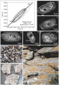
The first U-Pb isotope-geochronological data were obtained on the age of early collisional granitoids of the Matut massif (Western Sangilen, SE Tuva). The rocks that have been studied are assigned to magnesian, calc-alkaline, high-potassium, and low-peraluminious varieties. LA-ICP-MS analysis on two zircon samples showed that the Matut granite massif formation age corresponds to 522 Ma (U/Pb, LA-ICP-MS, zircons, 520±3 Ma (sample KT-1070) and 524±3 Ma (sample KT-1324)). Thus, the Matut massif granitoids are among the most ancient in Western Sangilen and were formed at the early collisional stage of the structural evolution of the region. Based on the data obtained, an assessment was made of the duration of collisional orogeny on the northwestern margin of the Tuva-Mongolian massif. The initiation to collapse period of the orogen is at least 80 million years.
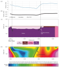
The paper examines the specific granitoid magmatism of the northern sector of the Kibaran orogenic belt in the general context of geodynamic typification of granitoids. It presents parameters and main features of the structure with an emphasis on the sectorial nature of the belt typical of intraplate settings and shows the geological features of the eastern and western blocks of the northern sector. The paper provides general information on S- and A-type granitoids and a description of the geological position and macrofeatures of "reference" massifs. The petrochemical characteristics of S- and A-granitoids are given using various diagrams. Analysis of geochronological database available to date (including Rb-Sr isochron age of rocks and SHRIMP U-Pb age of zircons) shows the multi-pulse nature of the manifestation of intraplate granite formation. Along with the main stages (~1375, ~1205, ~986 Ma), there are five others. Based on the total dataset, S-type granitoids in Burundi are characterized by the crust-mantle interaction signs which are somewhat contrary to the generally accepted opinion that they are purely crustal. At the same time, some varieties of A-type granitoids are characterized by corundonormativity which makes them more similar to the S-type. Thus, signs of convergence between S- and A-granites are characteristic of some intraplate environments such as "hot spots", primarily of those longlived and multi-pulse, with the relevant protolith represented by a complex of sediments with high exogenous differentiation. One of the version of the granite formation model is illustrated by the corresponding figure.
There are presented the results of geochemical studies of the Vendian-Cambrian terrigenous rocks in the Upper Kalar depression– sandstones of the Silimkun formation, exposed in the floodplain of the Kilcheris River (left tributary of the China River), in the upper reaches of the Kemen River. The rocks are enriched in Sc, Cr, Nb, V, Co, Ni, as well as in Mo and heavy rare earth elements. This study demonstrates a rare pairwise correlation between Mo and Cr. A strong positive correlation of P with Nb, Ti and Fe is indicative of P sorption phenomena in alteration products of titanium minerals (e.g. leucoxene). It has been found that the sandstones of the Silimkun Formation were formed as a result of the destruction of granitoids of the Kalar massif – presumably granite porphyries and fine-grained porphyritic biotite granites. The influence of the gabbro-norites of the Chiney complex, enriched in trace elements commonly found in rocks, is less pronounced.
RECENT GEODYNAMICS
Quantitative assessments of seismic hazard in seismically active areas depend to a large extent on the intensity-distance attenuation laws which are used in calculations. To account for epistemic uncertainty in the nature of seismic effects, it is recommended to perform probabilistic seismic hazard analysis using several different attenuation relationships. The most effective tool for their selection is the ranking procedure which consists in attributing a weight to one or another equation depending on the degree of compliance between the equation-based seismic effects and the real experimental data available for the region under study. The article presents the results of ranking intensity attenuation laws derived for Central Asia. Ranking was carried out by LH and LLH methods. Based on the ranking results, these has been made a generalized attenuation model used subsequently in PSHA for Uzbekistan. Consideration was given to three alternative models of seismic sources: area sources, active faults, and seismogenic zones. Parameterization of the models considered involved determining seismic potential, frequency of recurrence of earthquakes of different energy levels, and the predominant type of motions in each earthquake source. Seismic zoning maps of Uzbekistan in points of the MSK-64 intensity scale have been compiled for different probabilities of occurrence of non-exceedance level earthquakes in the next 50 years.
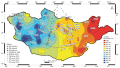
Crustal thickness beneath Mongolia was determined using the teleseismic receiver function H-k stacking method, which employed waveform data from broadband seismic stations in Mongolia. The findings reveal that the crust of Mongolia thickens from east to west, with the thickness reaching 63 km in west Mongolia and 35.9 km in east Mongolia. In the central part of Mongolia, the average thickness of the crust is approximately 45 km. The characteristics of P-to-S converted phases and negative amplitudes in stacked receiver functions, may be attributed to regional tectonostratigraphic terranes in Mongolia. Subsequently, a general map of the crustal thickness of Mongolia was generated by combining the results of this study with those of other seismological studies and the CRUST1.0 model of the Earth’s crust.
Bandar Lampung City is located at the southeastern tip of Sumatra Island, an area highly prone to earthquake and tsunami disasters. Along the Sumatra Island, there are seismic faults stretching along the Bukit Barisan Mountains. In the Bandar Lampung region, one of these faults is the Panjang Lampung fault. Gravity methods are commonly used to identify subsurface structures based on variations in rock density. This study aims to identify the subsurface structure of Bandar Lampung City based on gravity anomaly modeling, both 2D and 3D models. The research consists of three main stages: data correction, data processing including spectrum analysis, moving average, second vertical derivative analysis, and subsurface structure modeling. The complete Bouguer anomalies in the study area range from 41.9 mGal to 73.3 mGal. Modeling results indicate the presence of structures such as the Panjang Lampung fault in the Northeast and a graben in the Central region, verified through SVD analysis and geological information. The existence of the Panjang Lampung fault, classified as an active fault, along with volcanic pyroclastic rocks and significant sediment layers in the central region, makes the research area potentially susceptible to the impact of amplification in the event of an earthquake disaster.

Geological and geomorphological studies of the northeastern branch of the Baikal rift zone have revealed structural features of sedimentary strata, as well as the features of lithology and interaction of heterochronous loose sedimentary complexes, block structure of rift valley bottoms and their mountain border, fault network, and activated Cenozoic faults. The Middle Pleistocene neotectonic uplift was identified on the southern slopes of the North Muya and the Kodar ranges and in the mountains bordering the Muya-Kuanda and Parama rift valleys. The authors have studied the parameters of this uplift, determined neotectonic movement amplitudes in the uplift areas, traced the marginal disjunctives and the kinematics of their movements, and identified homochromous sedimentary strata and determined their formation age.
The activation of tectonic processes, during which the neotectonic uplift was formed, occurred in the early Middle Pleistocene, before the onset of glaciation. The formation of a dammed lake in the system of Muya-Kuanda rift valleys is associated with the tectonic damming of the Vitim River. During the Middle Pleistocene glaciation, the Kodar Range glaciers have twice formed the ice dams in the area of Lake Oron, which led to the emergence of dammed lakes in the Vitim valley connected with lakes in the Muya-Kuanda troughs. The shoreline of these lakes is preserved as a high rock terrace with an absolute height of 860±10 m along the perimeter of the rift valleys.
In the Late Pleistocene, the terrace complex in the Muya-Kuanda rift valleys was mainly formed under the influence of climatic factor.
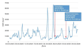
The paper presents the results of processing of the soil radon volume activity (RVA) monitoring data obtained at the Yuzhno-Kurilsk station from 2019 to 2023. There have been confirmed the patterns obtained previously for the reflection of tectonic events in the variations of RVA. There has been made a comparison showing the coincidence of the sizes of the "near" zone with those of the "far" zone, and the time of manifestation of the RVA anomaly before the earthquake.
TECTONOPHYSICS
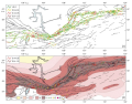
Tectonophysical zoning of active faults of the Baikal rift system (BRS) was performed based on the degree of hazard caused by the generation of earthquakes of magnitude 7.0 and higher. The first basis for this procedure was the results of the natural stress state reconstruction, earlier performed from seismological indicators of rupture deformations (earthquake focal mechanisms). The second important element of fault zoning was electronic maps of active faults of Eurasia hosted on the GIN RAS sever. Within the algorithmic framework for Rebetsky’s method of cataclastic analysis, both of these datasets allowed calculating the Coulomb stresses for the segments of the BRS faults. During the study, a development of the cataclastic method has been carried out in using a diagram of brittle fracture as the Mohr–Coulomb model, considering a decrease in the range of positive Coulomb stress values with an increase in effective normal stress levels. Such an approach provides a more reliable identification of the fault segments with the maximum Coulomb stress levels. The performed calculations showed that in the BRS crust there are several up to 50 km long fault segments having critically high (80–100 % of the maximum) and high (40–80 % of the maximum) Coulomb stress levels. It is these corebased hazardous zones that are considered as places where seismogenic ruptures of future М>7.0 earthquakes may start. There have been distinguished three zones that present such hazard: 1) in the western segment of the BRS in the western part of the Tunka Valley in the Tunka, Khamardaban-Mondy and Baikal-Mondy fault systems; 2) in the Selenga River delta in the Proval, Delta, Ust-Selenga and Sakhalin-Enkhauk fault systems; 3) within the northeastern flank of the BRS on the fault system of the Muyakan basin (along the North Muya ridge). It is proposed to perform tectonophysical monitoring of changes in the stress state of these three zones and make observations of their surface motions using remote sensing methods.
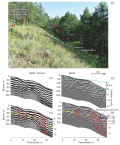
Seismogenic deformations of Cape Shartlay represent a very young fault system on the northwestern coast of Lake Baikal. Their study is providing an important opportunity to measure earthquake magnitudes, to identify areas where earthquakes are more likely to occur, and to estimate the probability of earthquake occurrence as applied to seismically active Baikal region. In this connection, the present work was aimed at characterizing in detail the structure, displacements, and reconstruction of the rupture propagation model. The study is based on photogrammetric processing and interpretation of the unmanned aerial survey data, as well as on morphostructural analysis of the displacement profiles and georadiolocation (GPR) data. It has been found that seismogenic ruptures of Cape Shartlay formed under prevailing extension conditions during no less than two earthquakes with magnitudes Mw≥7.0, Ms≥7.2. Seismic rupture propagation was primarily northward. The main rupture with displacement amplitude of more than 2 m contributed 39 to 93 % to the total surface displacement depending on the amount of dislocations on the transverse profile. It is shown that the length of a certain rupture increased almost instantaneously, then displacements along some of the ruptures stopped. A significant elongation of ruptures is primarily due to their merging. The present-day seismogenic zone is highly permeable. According to the tectonophysical model of formation of inner structure of the fault zone, the development of the seismogenic rupture system of Cape Shartlay corresponds to the late disjunctive stage. This means that the rupturing process in this segment of the North Baikal fault may not have stopped yet, and the lack of large earthquakes in the instrumental record implies the accumulation of stress in its southern part. The obtained results provide an opportunity to reconstruct the development of large fault zones by studying the displacement profiles and, therefore, to localize more precisely the places where future earthquakes may occur.
Dynamic rupture scenarios on various fault geometries are studied extensively in the literature for domains with the planar top surface. However, landscapes on the earth, particularly in tectonic regimes, can undulate upwards or downwards depending on faulting conditions. In this paper, we studied a dipping fault model with a dip fault angle of 60 degrees, inspired by the 2D version of dynamic rupture benchmark TPV10 from the Southern California Earthquake Center (SCEC). A topographic feature adjacent to the fault is introduced in the form of a hill or a valley. The shape of the undulation was varied from semi-circular form to Gaussian profile. This paper examines the impact of topographic features (valleys or hills) on slip amplitude on a fault. The distance at which the features exist also affects the amount of slip on fault, ruptured in that region. The results for a couple of different radii of semi-circular formation and equivalent standard deviation of Gaussian undulation are also summarized in this paper. The study depicts that the topography in the vicinity of the fault can affect the magnitude of slip propagation on fault surface.


