


RECENT GEODYNAMICS
Between 2010 and 2016, a series of 11 strong M>6 earthquakes occurred in New Zealand. In the area covering the epicentral zones of these seismic events, the spatiotemporal characteristics of movements and deformations of the Earth’s crust were obtained based on the processing of continuous satellite GPS observations at 64 points of the geodetic network. Using these data, we have studied the evolution of horizontal movements and deformations in order to reveal the possible relationship between the observed deformational and seismic processes. Analysis has been made on the total shear deformation, since the main tectonic structures of the region are faults with a shear mechanism of displacement of their sides. The presence of a giant mantle superplume in the area was the reason for the study of the behavior of horizontal dilatation deformation, and horizontal and vertical crustal motions. Based on the obtained digital deformation models, there were created kinematic visualizations, which are synoptic animations providing direct observations of the seismic deformation process and their heuristic analysis. The study revealed that a series of the strongest earthquakes may be interconnected by a long-term single deformation process, which is caused by the occurrence of an anomalous total shear deformation. The general maximum of shear deformation, dilatation deformation, and horizontal and vertical displacements are concentrated in the center of mantle superplume activity. Prior to strong seismic events, there occur zones of deficit (minimum) displacements of the Earth’s crust in the area of future epicenters, which is of research interest in terms of predicting their locations.
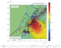
The strongest earthquakes with magnitudes Mw 8–9 generate coseismic displacements of the Earth’s crust, covering entire regions of the world. These displacements can be recorded using observations provided by the independent geodetic GNSS networks. The data of these networks are processed using different algorithms and methods for analyzing satellite observations, methods for calculating the coseismic shift, and different implementations of the coordinate system. These factors lead to "inconsistency" of the combined displacement fields and the appearance of additional errors in the results of coseismic effects modeling. The paper proposes a method for combining the fields of coseismic displacements of the Earth's crust, obtained in the far-field zone from the source according to data from heterogeneous GNSS networks. The results of applying the proposed method are demonstrated by the example of combining the fields of coseismic displacements in China, South Korea and the south of the Far East of the Russian Federation, initiated by the catastrophic Tohoku earthquake on March 11, 2011, Mw 9.1, as well as the calculation and analysis of the unified field of coseismic deformations of the region under study.
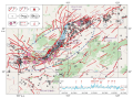
Based on the data from the Arctic regional seismic stations, the article presents the results of studying the swarm seismicity of the Gakkel Mid-Ocean Ridge, located in the Arctic Ocean. The active spreading processes of ultraslow ridges with spreading rates of less than 20 mm/yr, which include the Gakkel Ridge, are still poorly understood as compared to the MOR in the Atlantic and Pacific oceans, with spreading rates of more than 25 mm/yr. In 2012–2022, there were identified eight swarms: one within the western volcanic segment of the ridge, others – in the eastern volcanic segment. No earthquake swarms were recorded in the central amagmatic segment of the ridge; the recording therein covers primarily single earthquakes and aftershock sequences. Spatially identified swarms are confied to some volcanic centers revealed earlier from the geological and geophysical data during complex expeditions. The ridge segment at coordinates ∼85…∼93° E is characterized by the most intense manifestations of volcanic processes. The spatial distribution of swarms may also indicate potential presence of volcanic structures that have not yet been identified from the geological, geophysical and geomorphological data. In the temporal domain, there can be preliminarily distinguished a 5-year swarm activation cycle, which, however, requires additional verification over a longer time interval. The swarm seismicity of the slowest spreading Gakkel Ridge cannot be described by a simple model of volcanism and magma intrusion into a symmetrical rift; it is rather a result of a complex interaction between diking and faulting with magma transport along the faults with potentially significant seismic activities. There can probably be suggested a regular combination of the processes of volcanic activation and seismotectonic destruction, which is especially pronounced in the locations of transverse faults. The results described in this article expand our understanding of the manifestation of volcano-tectonic processes occurring within the slowest speading Gakkel Mid-Ocean Ridge.
The explosive eruption of the Hunga Tonga-Hunga Haapai volcano occured on January 15, 2022 at 04:02 UTC led to generation of covolcanic ionospheric disturbances that spread over long distances. Using GNSS data obtained at permanent stations of the IGS network and sites located on the territory of Primorsky Krai, the search and analysis of ionospheric disturbances over the territory of Primorsky Krai and adjacent areas was performed. The velocity of the covolcanic ionospheric disturbances recorded over the Primorsky Krai reached about 340 m/s, and the average amplitude was equal to 1.0 TECU. The results obtained from GNSS-data were also compared with the results of observation data obtained by a laser strainmeters (oriented in the directions "north – south" and "east – west") and a laser nanobarograph located at the Schultz Cape (the south of Primorsky Krai). As a comparison result, time delays between the moments of fixation of disturbances in the troposphere and ionosphere were found. The delay between the first peaks of disturbances was equal to ~50 min.
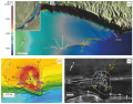
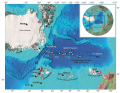
An integrated study of mud volcanoes in the World Ocean is important for making assessment of potential geological-ecological disasters caused by rapid large-volume gas discharge into the water column and mud volcano eruptions at the bottom. The study of mud-volcanic activity in the past and determination of its periodicity are pioneering for the Baikal. The mud volcanoes and other hydrate-bearing structures are largely concentrated in the Middle Baikal basin along the tectonic faults. The most representative example of these phenomena is the "Gydratny" fault, four of six structures along which are mud volcanoes. An integrated geological-geophysical study (seismoacoustic and hydroacoustic sounding and geological sampling) of the "Novosibirsk" mud volcano, the largest and well-pronounced feature of the lake bottom relief, confirmed its structural identity with classical submarine mud volcanoes. The "Novosibirsk" mud volcano possesses all major elements of other single hydrate-bearing mud volcanoes of the lake which include volcanic cone in the bottom relief, vertical acoustically not transparent feeding channel, mud-volcanic breccia, gas saturation, and gas hydrates. This makes it one of the reference hydrate-bearing mud volcanic-type structures of Lake Baikal.
The analysis of the bottom hydroacoustic profiling yielded evidence of the Late Pleistocene mud-volcanic eruptions shaped as two layers-flows at sub-bottom depths of 15 and 26 m (30 and 50 kyr ago, respectively). The presence of mud-volcanic breccia beneath the thin Holocene diatomic silt deposits testifies to the Holocene mud volcano activation due to the warm fluid rising from the depths to the volcano roots along the active segment of the tectonic fault in accordance with the model of the "Baikal-type" mud volcanism. Using the "Novosibirsk" mud volcano and the "Gydratny" fault as an example, it can be shown that the past tectonic activity of the Baikal basin may be determined based on the knowledge of the structure and evolution of the mud volcanoes of the lake.
PALEOGEODYNAMICS
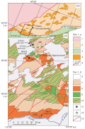
The palingenic calc-alkaline granitoid massifs of the Olekminsky complex form a magmatic belt stretching within the Western-Stanovoy terrane in the northeastern direction for more than 700 km. New U-Pb LA-ICP-MS dates for zircons from the granodiorites of the Marekta-Bereinsky massif of the Olekminsky complex and the granodiorites of the Yamninsky massif of the Krestovsky complex were obtained, amounting to 371±4 Ma and 364±5 Ma, respectively. These geochronological data are well consistent with the 355–358 Ma ones, therefore suggesting the Late Carboniferous age of quartz-diorite-granodiorite-granite rocks of the Olekminsky complex. However, these dates are not correlated with the existing legends of geological maps covering the area of the Western-Stanovoy structural-formation zone or the Western-Stanovoy terrane, as the intrusive formations of the Olekminsky complex are dated as the Early Paleozoic. In addition, new geochronological data call into question distinguishing of a separate Early Paleozoic Krestovsky granitoid complex.

Geochronological studies have been made on the main types of rocks from the Burpala alkaline massif and two gabbro and gabbro-diorite dikes located nearby. U-Pb LA-SF-ICP-MS zircon geochronology for the Burpala massif yielded a date of 294±2 Ma for gabbro crystallization, 607±4 Ma for diorite crystallization, 298±2 and 296±2 Ma for melanocratic alkaline and nepheline syenite crustallization, 291±2 and 293±3 for quartz and quartz-containing syenite crystallization, and 293±3 Ma for alkaline granite crystallization. The stage of formation of the massif rocks (298–291 Ma) coincides with the formation period of alkaline rocks from the Synnyr pluton and some alkaline complexes of the Vitim segment of Transbaikalia and confirms a widespread occurrence of post-collisional alkaline magmatism in Western Transbaikalia.
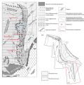
A technique for balancing cross-sections is used to construct geometrically consistent structural sections through fold-thrust belts. Unlike the predecessor studies, the balanced cross-sections in this study were obtained using the deep seismic sounding and well data and Move Software. Two detailed balanced cross-sections pass through the central part of the South Verkhoyansk region: the 80 km long Yudoma cross-section running along 59°45ʹ N, and the 122 km long Allakh-Yun cross-section within 60°40ʹ – 61°00ʹ N. Both sections are characterized by a thin-skinned structure, "mechanical stratigraphy", emergent leading imbricate fans in the foreland, thick Riphean strata, and eastward dip of the detachment surface. The surface shortening values are ~33 % for the Yudoma cross-section and ~26 % for the Allakh-Yun cross-section, showing an old-to-young-complex decrease from 39 % for the Yudoma cross-section to 19 % for the Allakh-Yun cross-section. On the Yudoma cross-section, the detachment occurs in the Middle Riphean deposits and dips down to 8 km; on the Allah-Yun cross-section, it occurs in the Lower Riphean deposits and dips down to 15 km. The difference in the detachment level may indicate the presence of a ramp between the cross-sections or an inaccurate localization of a ramp between the Central and Kyllakh-Eibeke-Khayata segments. The changes in the geological structure across and along the strike of the orogen are traced; the obtained cross-sections are compared with each other, with other cross-sections across the South and West Verkhoyansk regions, and with the cross-sections through the foreland fold and thrust belts of the Urals, Appalachians, and Cordillera of North America.
TECTONOPHYSICS
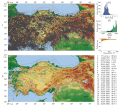
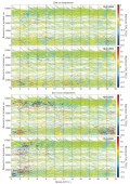
The paper deals with the study of seismicity and the crustal stress-strain state of Turkey whose tectonics is caused by relative movements of the African, Aegean, Arabian, Anatolian, Black Sea and Eurasian plates. Seismotectonic deformations (STD) were calculated using the approaches proposed by Yu.V. Riznichenko and S.L. Yunga. The distribution of seismicity, average annual STD rate (STD intensity), seismogenic rupture concentration parameter and the Tsallis parameter was plotted from the earthquake catalog data analysis (more than 300000 events for 1900–2022). The representative part includes the events with М≥2.5. The distribution of the above-mentioned parameters was calculated for a 0–40 km layer wherein most of the earthquakes are located. Deep-focus earthquakes occur at a depth to 170 km. The maximum annual number of earthquakes (more than 90) was recorded in Balikesir Province. Seismicity and STD intensity analysis was made on the periods of 1997–2009 and 2010–2022 for the western and eastern parts of Turkey and for the destructive February 6, 2023 earthquake area. The number of earthquakes recorded in the western part of Turkey (75 %) largely exceeds that recorded in the eastern part (25 %). In the period 2010–2022, there was an increase in the number of earthquakes in the eastern part of Turkey relative to the period 1997–2009, which made up 38 % of the total number of earthquakes. The studies of STD direction are based on the earthquake focal mechanism data (807 events for 1976–2023). STD intensity in the February 6, 2023 earthquake area, with regard to the February 6, 2023 earthquakes, is 1.34⋅10–6 year–1, and the background intensity for the entire period of observation (1900–2022) is –10–10 year–1. The STD maps show the diversity of deformation settings in the study area. Turkey is largely dominated by the horizontal shear mode (eastern and central parts). The extension mode manifests itself in the southwestern part. The western part of Turkey and the southern part of the East Anatolian fault zone are characterized by transtension mode. The Lake Van area is characterized by transpression mode. The shortening axis direction changes from sublatitudinal in the west of Turkey to submeridional in the east. STD tensors served as a base for plotting the distributions of the Lode – Nadai coefficient με and the vertical component. Based on the seismic and GNSS data, a comparison was made between the shortening and elongation axes directions.
Long series of the emanation monitoring organized at Tyrgan (2018–2023), Buguldeika (2020–2023) and Maksimikha (2022–2023) stations in the central part of the Baikal Region (the Eastern Siberia) are studied to reveal the relationship of the subsurface radon volumetric activity (RVA) with the seismicity of the Baikal rift zone (BRZ). The comparison of the weekly averaged RVA values at different stations and the degree of dependence of this parameter on the logarithm of the total earthquakes energy (LgΣE) showed that during the periods of seismic activity the impact of tectonic forces makes significant corrections in the character of emanations, which in general is determined by non-tectonic factors. It has been established that seismic activity represented by the enough strong for the Baikal Region earthquakes with K≥13.3 correspond to synchronicity intervals of RVA at different monitoring stations, as well as coincidence of maximum values of the logarithm of the total earthquakes energy with local maximums of the correlation coefficient between RVA and LgΣE parameters. The area, including the earthquake epicenters that generated such an emanation response at monitoring stations, is in the form of an ellipse extended in the northeastern direction – along the main fault structures of the BRZ. The obtained results, besides confirming the previously proposed model of radon field formation in the Baikal Region under the influence of external and internal forces, provide the for the identification of further stable precursors of strong earthquakes based on a comprehensive analysis of data from a branched emanation monitoring network.


