


Geodynamics & Tectonophysics is a Scientific Peer-Reviewed Online Publication
ISSN 2078-502X
The Federal Agency for Supervision of Communications, Information Technology and Mass Communications (Roskomnadzor) – Media registration certificate ЭЛ № ФС 77-71242 dated 17 October 2017.
12+
Publisher: Institute of the Earth's Crust, Siberian Branch of RAS.
Founders: Institute of the Earth's Crust, Siberian Branch of RAS; Siberian Branch of RAS.
First issue: January 2010.
Published: six times a year.
Languages: Russian and English.
Access to publications is free and immediate.
Geodynamics & Tectonophysics is indexed as follows:
- K1 in Higher Attestation Commission (VAK), the RF Ministry of Education and Science, as a media for publication of scientific results of Ph.D. theses
- White List of Scientific Journals (L1)
- Scimago Journal & Country Rank SJR (Q2, SJR 0.32)
- Scopus (Q3 CiteScore 1.4)
- Emerging Sources Citation Index on Web of Science platform (Q4, IF 0.8)
- GeoRef, GEOBASE
- Russian Science Citation Index RSCI
- Russian Science Index (E-Library)
- Directory of Open Access Journals (DOAJ)
- CrossRef (each article is assigned an individual index, DOI)
- Electronic libraries
The Online Publication publisher IEC SB RAS is a member of the Association of Science Editors and Publishers (ASEP).
Main topics of the Online Publication cover a wide range of problems in paleogeodynamics, modern geodynamics, structural geology, tectonics, tectonophysics and experimental tectonics. The Online Publication publishes articles covering issues of genetic relationships between geodynamic processes of the past and present, synchronism in development of structures and their current spatial and temporal patterns, causes and conditions of manifestation of processes accompanying the evolution of the lithospheric structures, as solutions of such problems are important for practical application (paleo-and modern geodynamics, tectonophysics, seismicity, ore deposits, subsurface degassing, new achievements on the basis of experimental and mathematical methods of research, etc.) In this regard, the Online Publication welcomes a very broad geological and geophysical audience.
As is known, in the vast majority of cases important scientific concepts are born in meaningful discussions on pages of scientific journals. From these positions, the Online Publication pays special attention to controversial issues regarding common problems of geology and geophysics. There is no doubt that some of the highly contentious problems, that are currently in hot debate, as well as highly specific aspects of geology and geophysics will be more deeply substantiated and justified in the coming years and thus transformed into well-based scientific concepts or directions of research. Promoting and facilitating the new knowledge of such a mould is a key challenge for our scientific Online Publication.
Communication between authors and the Editorial Board is governed by the rules adopted in the leading peer-reviewed journals, and its efficiency is a key prerequisite due to the electronic nature of the journal. On the website of the Geodynamics & Tectonophysics, up-to-date on-line information on how many people read articles published in our Online Publication is available for visitors – a special box is allocated for automatic registration of readers to monitor references to every article published.
The Editorial Board welcomes submissions from across the world. Authors are encouraged to submit articles and research/discussion notes on topics relevant to the Online Publication’s scope and get involved in the mutually beneficial exchange of new scientific information and improvement of the overall awareness of achievements in the Earth sciences.
Photo and cover design made by Sizov A.V.
Current issue
PALEOGEODYNAMICS

The paper presents detailed petrographic, geochemical, Sm-Nd isotope studies, as well as U-Pb (LA-ICPMS) geochronological studies of detrital zircon grains from gneisses of the Olkhon complex, distributed together with marbles and quartzites in the Anga-Sakhyurta zone of the Olkhon terrane of the Central Asian Orogenic Belt. Among the gneisses are scapolite-pyroxene-plagioclase, biotite-pyroxene-amphibole-plagioclase, garnet-biotite-amphibole-plagioclase, and pyroxene-amphibole-biotite-plagioclase varieties. Based on the concentrations of major oxides, the gneiss protoliths are reconstructed as carbonaceous, ferruginous siltstones and argillites, and as carbonate siltstones. The concentrations of most of the rare elements and their ratios in gneisses, including La/Sc, Zr/Sc, Th/Co, Ti/Zr, imply they may have resulted from mixing of mafic and felsic igneous rock materials. The analyzed gneisses have ɛNd(t) values of +1.3 and –5.6, which may indicate that the rocks of one composition or another contribute differently to their source. The age of most of the detrital zircon grains in scapolite-pyroxene-plagioclase gneiss varies from 552 to 922 Ma with maxima at 620 and 780 Ma. On the basis of the youngest detrital zircon age (552±8 Ma) and the age of metamorphism of the rocks of the Anga-Sakhyurta zone (460‒490 Ma), it may be concluded that the accumulation of sedimentary protoliths of the rocks of the Olkhon complex took place there during the interval 550 to 490 Ma. The totality of geochronological data on the gneisses from the Olkhon and Shebarta complexes of the Anga-Sakhyurta zone implies age-related similarity in the accumulation of protoliths of metamorphic rocks of both complexes (Cambrian), as well as their formation as a result of the destruction of similar, predominantly Neoproterozoic source rocks, which could be rocks of the Neoproterozoic composite superterrane, attached to the Siberian Craton at the 600‒610 Ma. The accumulation of sedimentary protoliths of the Olkhon and Shebarta complexes took place in a single marine basin facing away from the Neoproterozoic superterrane towards the Paleo-Asian Ocean. On the basis that metagabbroids and metahyperbasites with subduction-related geochemical characteristics are associated with the metasedimentary rocks of the Olkhon complex, this sedimentary basin can be considered as a back-arc basin that emerged as a result of initiation of subduction zones in the Paleo-Asian Ocean. Late Cambrian – Ordovician accretionary-collisional events associated with the accretion of island-arc systems of the Paleo-Asian Ocean to the Siberian Craton, as well as the accompanying shear tectogenesis, led to a violation in the initial location of rock associations of the Olkhon and Shebarta complexes, their tectonic mixing, and, accordingly, to the formation of the collisional collage of the Anga-Sakhyurta zone of the Olkhon terrane of the Central Asian Orogenic Belt.

This study presents the results of investigations into volcanic strata of the Zharma-Saur zone, located in the western part of the Hercynian Ob’-Zaisan folded area at its boundary with the Early Paleozoic Boshchekul-Chingiz folded area, which forms part of the Kazakhstan composite block (paleocontinent). U-Pb geochronological studies revealed two distinct groups of volcanic rocks within the zone: Early Carboniferous (~345 Ma) and Late Carboniferous (~303 Ma). Low-K tholeiitic and calc-alkaline basalts, basaltic andesites, and andesites represent the Early Carboniferous volcanic rocks, which are the main constituents of the eastern Zharma-Saur zone. The Late Carboniferous rocks comprise a trachybasalt to trachyrhyolite bimodal series, which forms an isolated brachysyncline in the eastern part of the zone. The formation of the early volcanic rocks corresponds to the subductional phase of the zone evolution, while the later volcanics may be associated with post-collisional extension processes.

The paper deals with the distribution of the major oxides and trace elements in the Paleozoic terrigenous rocks of the Ildikan and Gazimursky Zavod formations from the Yamkun series of the Argun continental massif. The main purpose of the study is to reconstruct depositional settings and sources of clastic material. It is shown that the terrigenous rocks of the Ildikan and Gazimursky Zavod formations correspond to different lithotypes: graywackes, arkoses, and litharenites. According to the variations in Zr/Sc and Th/Sc ratios, the rocks of the Yamkun series are the first-cycle sediments. Whole-rock geochemical composition of studied rocks suggests that the main sources of clastic material were felsic and intermediate igneous rocks, with a subordinate amount of mafic rocks. The use of these data in combination with the U-Pb geochronological data on igneous rocks from the Argun massif implies that the initial material was mainly sourced from the Tonian, Cambrian, Ordovician and Early Silurian felsic and intermediate igneous rocks, widely abundant within the Argun continental massif. Additional sources of clastic material may involve the Paleoproterozoic orthogneisses from the Xinhuadukou complex of the Argun massif. The position of figurative points of the composition of the Paleozoic terrigenous rocks from the Yamkun series of the Argun massif on the tectonic discriminant diagrams in combination with geological data indicates a passive continental margin setting for the Lower-Middle Devonian deposits of the Ildikan formation and an active continental margin (or island-arc) setting for the Lower Carboniferous deposits of the Gazimursky Zavod formation.

The relevance of the work is determined by a poor knowledge of metamorphic processes in the Precambrian complexes of the Urals. The object of the study is the Belokamenka metamorphic complex of the Ishemir anticlinorium of the Northern Urals. The aim of the work was to characterize and determine the PT-parameters of metamorphic transformations of the rocks of the Belokamenka complex based on the analysis of mineral and rock compositions. PT-estimates were obtained by applying the multi-equilibrium geothermobarometry (winTWQ) method. To determine the general patterns of metamorphic mineral formation, PT-diagrams of phase equilibria were also calculated based on the minimization of the Gibbs energy. The peak metamorphism parameters – T=619 °C, P=7.4 kbar – were determined, and a conclusion was made about the progressive nature of the metamorphic process in the E-W trending, regular lateral zones of chloritoid, chlorite, staurolite and kyanite. The medium-temperature moderate-to-high-pressure type of metamorphism revealed for the Belokamenka complex, which dates back to 973±49 Ma, allows us to associate it with the areas of manifestation of the Grenville orogeny.

The Panghazjilga igneous complex in the eastern part of the Central Pamirs is one of the few Cambrian intrusive formations in the region. In our study, we address a number of questions that contribute to understanding the nature of the rocks in the complex. The quartz diorites and granodiorites of the Panghazjilga complex, which constitute the eponymous massif, are products of crystallization from a single parent andesitic magma. The fact that mafic microgranular enclaves (MME), isotopically similar to the rocks of the complex and represented by monzodiorites, are present in quartz diorites and granodiorites, as well as the rock association itself, indicates the involvement of mafic and acid magmas in the process of magma generation. The predominance of amphibole crystals and the absence of pyroxene in the quartz diorites, granodiorites and monzodiorites from the enclaves suggest that amphibole was the principal early-crystallizing mineral, and the dominant role of amphibole and biotite in the rocks indicates a significant influence of H2O on crystallization. The composition of the rocks from this igneous complex, as well as that of the monzodiorites from the enclaves, demonstrates their close connection with melting of a mantle source that interacted with crustal rocks (or their melts). In particular, this hybrid nature of the source explains the variable and enriched isotopic composition of Hf–Nd–Sr in the rocks that were considered earlier. We believe that the generation of magmas, which serve as a parent material for quartz diorites and granodiorites, involved heterogeneous sources: heterogeneous crustal source (predominantly subducted sedimentary material) and magmas that formed through partial melting of enriched mantle material altered during subduction. The formation of magmas, which are the source of granitoids of the Panghazjilga complex, was associated with the subduction of the oceanic crust of the Proto-Tethys beneath the northern margin of Gondwana.

This series of articles presents the first isotopic and palaeomagnetic data for rocks from the Early Carboniferous Berezovka complex of the Magnitogorsk zone. The aim of the work was to develop kinematic reconstructions for the time of its formation. For this purpose, in the vicinity of Bogdanovskoye Village, a set of 93 oriented samples was taken from nine sites; besides, two sets of 8 and 3 samples were collected respectively for geochemical and isotope-geochronological studies. Paper 1 presents the first isotopic ages for felsic volcanics from the Berezovka complex: rhyodacites – 348.5±3.1 Ma, fluidal rhyolites – 350.7±2.9 Ma, dacitic ignimbrites – 340.6±2.8 Ma, as well as geochemical characteristics for these rocks. The material composition of the studied volcanics is consistent with that of the rocks typical for the Berezovka complex. According to the newly obtained dates, Early Carboniferous volcanism started almost simultaneously throughout the southern part of the East Magnitogorsk zone and earlier than the date obtained paleontologically for its eastern part before. The newly obtaied data allow us to conclude that active volcanism in this region may have begun during the Rezhian substage of the Early Turonian.
TECTONOPHYSICS
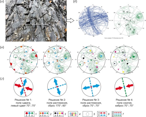
The paper considers the results of special-purpose mapping for the Natalka ore field (the Magadan Region, Russia), within which, according to most researches, a similarly named super-large gold deposit is controlled by fault tectonics. Actually, the groundwork for a formal-based mapping was laid by mass measurements of non-displaced fractures made in 52 geological-structural observation points. Their paragenetic analysis yielded local solutions concerning orientation and kinematics of the fault zones along which the displacement-related fracture networks were formed, same-type point-to-point trace solutions, and, therefore, a scheme of fault structures for the mapping area. This scheme reflects a fault-block style of the crustal destruction at the intersection of two large fault zones – northwestern Tenka and sub-latitudinal Inyakan-Kolyma. According to the formal principles of rank analysis of local solutions, there have been identified three regional dynamic settings of the tectonic knot structure formation: sub-meridional compression, NE-SW compression, and a shear related to WNW compression and NNE extension. The ore field was formed within the intersection of regional faults, and the shear setting has become decisive in the ore-hosting structure formation. Left-lateral shearing along the Tenka fault zone was followed by the right-lateral kinematics along the conjugate Inyakan-Kolyma fault zone – the disjunctive zone which influenced the northwest-trending faults, developed under the secondary extension conditions controlling the formation of major ore bodies of the Natalka deposit. A special-purpose mapping-based scheme of fault structures, as well as stress-state and structure-formation stage reconstructions, are largely consistent with the results of the previous large-scale studies based on the processing of the structural-geological data obtained from the multiyear exploration of the Natalka ore field. This fact, together with the experience of using a methodical approach for different geological objects and the opportunity for its operations automation at the current level of development of electronic technology, makes it possible to recommend a special-purpose mapping for solving applied problems within relatively small areas and for identifying specific features of the stress-strain state of the Earth’s crust at different tectogenesis stages in large natural landscapes.

The paper presents the results of neotectonic and neotectodynamic studies of the Surkhandarya depression. The depression is a structure of post-platform orogeny, characterized by the imposition of tectonic movements and deformations of different genesis. Taking into account the new geological and geophysical data, cartographic models have been made for fault-block tectonics, neostructure, and neotectonic zoning.
The study area, spanning from the northwest to the southeast, shows the second-rank northeast-striking overthrust reverse step-like fault zones: Kugitang-Baysun and Kelif-Sherabad-Sarygamysh-Surkhantau, with the fault plane dipping northwest. There have been identified third-rank northwest-striking transverse fault zones. Among them are fault zones along the Sangardak – Kyzyljar – Denau – Zarkosa, Akkapchigai – North Dasmanaga, Urgilisai, and Sherabad – Dzharkurgan lines. They are the boundaries of uplifts (Kaymazar-Dalvarzin, Uchkyzyl) and adjacent depressions. There have been noted the left-lateral northwest-striking and right-lateral northeast-striking shears. They are clearly defined along the relative displacement of the Cenozoic outcrop ridges (Kelif-Sherabad-Sarykamysh, Babatag mountain ranges).
Two second-rank regional stress fields were obtained for the study area. The first is characterized by the northwest (southeast) orientation of the compressive principal normal stress axis (σ3), with the southwest (northeast) direction of the extension axis (σ1) and the subvertical direction of the intermediate axis (σ2). This stress field is characteristic of the uplifts of the southwestern spurs of the Gissar Range and the piedmont Surkhandarya depression. The second stress field, within the Baysun basin and the Surkhandarya depression, is characterized by a sublatitudinal subhorizontal compressive stress axis (σ3) and a submeridional orientation of the extension axis (σ1), with a subvertical direction of the intermediate axis (σ2). This stress field determines the deformations of the MZ-KZ cover, forming shear zones, and the structural paragenesis accompanying this dynamic environment. The analysis shows that the involvement in the process of uplift occurs during the rapid rise of the western and northwestern anticlinal folds with their rising centers moving from west to east.

The paper presents the results of rock deformation measurements conducted in 2024–2025 on the Shikotan Island (Lesser Kuril Ridge). The measurements were conducted using strainmeters installed in the adit of the former Shikotan geophysical observatory, now the Shikotan seismic station of the Sakhalin Branch of the Geophysical Survey. The research was conducted by means of an instrumental complex developed specially for monitoring rock deformation. The goal of the work is to provide a comprehensive analysis of the variations of deformations of rocks depending on various natural processes.
The first results of the analysis showed the correctness of the employed deformation measurement technique. An important finding was the relationship between deformation rate changes and the local seismic regime. There has been a reaction from both components (alternating impulse) to strong remote earthquakes on July 20 and 30, 2025, in Kamchatka. It was shown that both components of soil deformation consistently reflect the passage of cyclones, which is expressed in short-term variations of an impulsive nature.
RECENT GEODYNAMICS

The Scythian-Ural seismogenerating zone is associated with neoseismic dislocations trending northeast similarly to the Cyprus-Caucasus neoseismic left-lateral shear belt. This zone exhibits the occurrences of seismicity. To assess the conditions for the occurrence of seismic events within the Scythian-Ural zone it is necessary to know its deep structural features. Accordingly, the purpose of the present study was to investigate the deep structure of earthquake source zones based on the analysis and generalization of all geophysical data available. Based on the integrated geophysical data, there have been determined the deep structural features of the Scythian-Ural neoseismic dislocation zone. It is shown that the stress-strain state of the Earth’s crust and mantle within this zone is regionally caused by the horizontal compression forces of the Caucasus and the Urals folded systems, which led to the formation of a system of dislocations trending northeast from the Scythian Plate to the Urals folded system. Within the Scythian-Ural neoseismic dislocation zone, there have been identified heterogeneities caused by the decompaction of the Earth’s crust and mantle. The dynamics of decompacted rock complexes in local areas was formed under a combined effect of horizontal compression forces and tectonic dislocations, with the latter inherited from the lower crust and upper mantle. These dislocations are associated with source zones of strong earthquakes with a magnitude of 5 or higher. In the future, the results of the research can be used to identify potential strong earthquake sources within the studied areas.
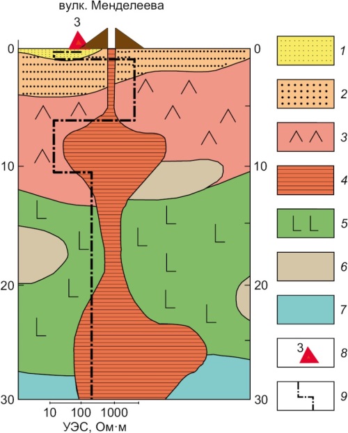
The paper presents the first results of magnetotelluric (MT) sounding on Kunashir Island. MT curves were inverted for one-dimensional inhomogeneous medium using effective apparent-resistivity curves. Deep geoelectrical models of the Mendeleev Volcano’s western slope have been compared using deep seismic sounding, earthquake converted-wave method, and potential-field measurement. There have been identified electrical conductivity features of the volcano-sedimentary cover and crustal zone, and an anomalously enhanced electrical conductivity of the crust and mantle, suggesting the presence of modern-day volcanic zones. Recommendations have been formulated on further geo-electrical investigations.

Priolkhonye, as part of the Olkhon region, is a unique geological testing ground where the structures of the the basement parts of the Siberian craton and the Central Asian Foldbelt are exposed on the modern erosional surface. The understanding of the structure of this region primarily comes from the ground-based geological mapping and remote sensing results. However, the applicability of remote sensing technologies in the study of the Priolkhonye region structure is limited, especially in depth extrapolation of the results. Therefore, it is essential to use geophysical methods that enable three-dimensional geological mapping. This article presents and discusses the results of studying the regional geological structure of Priolkhonye using transient (time-domain) electromagnetic sounding and self-potential methods. These studies have revealed for the first time the features of the regional-scale structure of Priolkhonye that do not come to light during the ground-based geological survey. An important result of the studies is that they yield questions concerning the geological interpretation of the geophysical data, which cannot yet be answered unambiguously under the current concept of the geological structure of Priolkhonye.

GPS measurements are an important tool for navigation and high-precision space geodesy. Of particular importance is the use of the GPS data for determining integrated water vapor (IWV) level within the lower neutral part of the atmosphere. Radiosonde (RS) data are also important for direct determination of the integrated water vapor. The values of the weighted mean temperature (Tm) in a vertical column are found from radiosonde launches in order to extract IWV values from GPS-derived total zenith tropospheric delay (ZTD) estimates. The total moisture content variability from 1999 to 2021 is considered based on the datasets of permanent GPS measurements, radiosondes and surface meteorology at IRKT (Irkutsk), YAKT (Yakutsk) and TIXI (Tiksi) observation points located in different-latitude zones.
The RS- and GPS-derived trends in moisture content were compared with the surface meteorological data-based model calculations. GPS measurements showed a good agreement with model calculations rather than with RS data. The tropospheric integrated water vapor tends to increase over the entire GPS observation period, and, despite a large latitudinal difference between the three observation points, there is a consolidated tendency at the level of 0.33±0.04 mm per decade.


