PALEOGEODYNAMICS
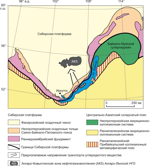
The analysis has been made on the modern data about the Neoproterozoic – Early Paleozoic geodynamic evolution of the southern flank of the Siberian Platform in order to identify the probable time and place of formation of hydrocarbons in sedimentary basins and their further migration from the foci of oil and gas formation to the zones of their accumulation, namely to the sedimentary deposits of the Chora formation of the Vendian Moty group (productive Parfenovo horizon). The conditions for the accumulation of hydrocarbons could arise in sedimentary basins of the passive margin of the Siberian craton, formed in the Neoproterozoic (710–650 Ma) after the breakup of the supercontinent Rodinia, separation of the Siberian craton therefrom and opening of the Paleoasian Ocean, as well as in the peripheral foreland basin, formed after the transformation of this passive margin at about 610 Ma ago. In the Baikal part of the Siberian Platform, the accumulation of hydrocarbon-containing sediments could occur in the rocks of the Uluntuy and Kachergat formations of the Baikal group, formed in the basin of the passive continental margin and the foreland basin, respectively. As a result of the large-scale Late Cambrian-Ordovician accretion-collision events that mark the formation of the Central Asian Orogenic Belt, hydrocarbons migrated westward from the Vendian deposits of the Uluntuy and Kachergat formations to the sedimentary sequences of the Chora formation of the Moty group, having formed the deposits of the Angara-Kovykta oil and gas accumulation zone (Angara-Lena oil and gas bearing region). Since over 90 % of the world hydrocarbon reserves are confined to sedimentary sequences of passive margins and foreland basins, it can be assumed that the proposed hypothesis may explain the nature of the origin of hydrocarbons, their migration, and accumulation in the deposits of the Angara-Lena oil and gas region. Subsequent processes, which significantly affected the redistribution of hydrocarbons specifically within this oil and gas region, were caused by neotectonic activation, which contributed to the formation of deposits in the Angara-Kovykta oil and gas accumulation zone.
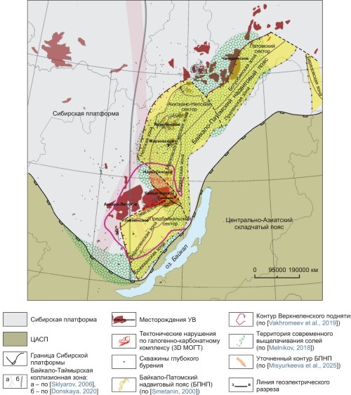
A comprehensive interpretation of modern geological and geophysical data served as a basis for refining a model of the deep structure of the junction zone between the Siberian craton and the Central Asian fold belt, which hosts the Kovykta gas condensate field (GCF). It has been found that hydrocarbon and hydromineral deposits in the allochthonous complexes are controlled by elements of the thrust system.
It has been shown that the Cenozoic tectonic reactivation plays a decisive role in the restructuring of the multi-stage natural reservoir system of the Kovykta field. Electrical prospecting methods have revealed the presence of modern highly conductive fluid migration channels both in the sedimentary cover and the basement. The inclined morphology of the conductors connecting the autochthonous and allochthonous reservoirs indicates the present-day hydrodynamic activity of the system. It is shown that evaporite leaching zones confined to thrust dislocations could serve as pathways for lateral and vertical hydrocarbon migration through the regional halogen fluid seal, thus contributing to thus contributing to the formation of secondary reservoirs in carbonate-sulfate sequences.
The obtained data are of importance in understanding the geodynamic evolution of reservoir filtration fields and minimizing geological risks when identifying new promising directions of petroleum exploration in the Angara-Lena and Nepa-Botuoba regions. A practical implication is the substantiation of shifting the exploration focus towards thrust-associated traps and the necessity of mapping active fluid-conducting systems.
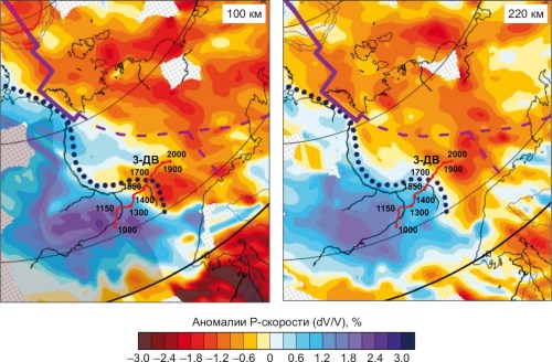
The 3-DV seismic profile data interpretation was used to obtain a geodynamic model for the deep structure of the southeastern margin of the Siberian craton and the South Verkhoyansk sector of the Verkhoyansk fold and thrust belt (VFTB). A determination has been made of the craton boundary, as well as of its reflection in the geological structure and geophysical fields. The model shows the mechanism of formation of thrust complexes on the craton margin and a compensatory underthrust beneath the craton of the lower crustal horizons of the fold-thrust belt, and explains the causes of abnormal RT-conditions reflected in the nature of the manifestation of metamorphism, magmatism, metallogeny and disjunctive tectonics. Using tectonic zoning, the parameters of the model are extended to the structures of the Southern Verkhoyanye and adjacent areas, which made it possible to determine the deep boundaries of the cratonic structures and their borders formed on the oceanic crust. The first are the margins of the Siberian craton and the Okhotsk terrane, the second are the adjacent VFTB structures. The boundary zone between the craton and the VFTB exhibited tectonomagmatic structures with high metallogenic potential. The obtained data make it possible to interpret the tectonic structure and development of the orogenic belt on the craton margin, and to relate the stages of its evolution to large Late Mesozoic geodynamic events in northeast Asia.
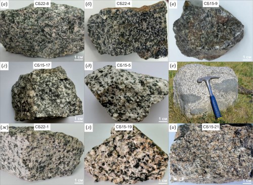
This paper presents new data on the age and distribution features of the main rock-forming components and trace elements in the rocks of the North Bichura gabbro-granite association, which is a petrotype of the Bichura intrusive complex. The chemical composition of the rocks studied corresponds to the gabbro, monzogabbro, monzodiorite, monzonite, granosyenite, moderately alkaline granite and leucogranite families. The geological structure and composition of the North Bichura rocks provide important insights into the Early Mesozoic tectonomagmatic processes in the southern part of Western Transbaikalia during the closure of the Mongol-Okhotsk paleoocean. LA-ICP-MS U-Pb zircon geochronology allows us to distinguish two stages of magmatic activity: 247–245 and 228–226 Ma ago, corresponding to the Middle and Late Triassic periods. The early stage was characterized by the formation of gabbro-monzonite rocks, and the late stage – by the formation of granitoid rocks. More than 20 million-year gap between the gabbroids and granitoids of the North Bichura pluton contradicts the model of rock formation based on differentiation of the initial basic melt. Two petrographic types of gabbroids have been distinguished that show different geochemical characteristics – amphibole-pyroxene and pyroxene-biotite. The first type is comparable to rocks formed in intraplate settings, while the second is similar to subduction zone magmatism. The formation of the Middle Triassic basic melts with different geochemical parameters most likely indicates their origin from two different sources: suprasubduction lithospheric mantle and asthenospheric mantle. Analysis of geochemical and geochronological data indicates the Early Mesozoic tectonomagmatic-related convergence caused by the closure of the Mongol-Okhotsk paleoocean.
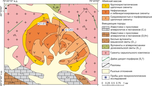
Studies have been made of the Abai alkaline rocks massif, located in the northeastern part of the ChingizTarbagatai zone of Eastern Kazakhstan. The Chingiz-Tarbagatai zone of Eastern Kazakhstan is located in the western part of the Central Asian Orogenic Belt (CAOB), the lithospheric evolution of which continued during the Paleozoic and was associated with the basin closure in the system of the Paleoasian Ocean. The 9 km² massif is characterized by an isometric shape with a clearly defined concentric zonal structure and represents a multiphase intrusion composed of several varieties of syenite. Potassium feldspar is the most prevalent mineral in syenite, while plagioclase, pyroxene (5 to 15 vol. %), and amphibole (5 to 20 vol. %) are less common. Most of the massif is composed of nepheline syenite rocks containing 5–10 vol. % of nepheline. Accessory minerals include apatite, zircon, and ilmenite. Studies of mineral composition and geochemical characteristics of the rocks revealed that the syenites formed during the evolution of a single magma melt composed of alkali-syenite or monzonite. This magma was formed probably as a result of primary alkaline-mafic magma differentiation. The U-Pb LA-ICP-MS dating of magmatic zircon grains for the first time yielded a relibale rock age estimate of 401–398 Ma, which corresponds to the Emsian stage of the Early Devonian. This refutes the previously accepted ideas about the Early Permian age of the massif and its intraplate geodynamic nature. When the data on the composition and age of the massif are compared with the data on the geological evolution of the region, it is apparent that the Abai syenite massif formation is related to the extensional processes in response to subduction of the Junggar-Balkhash oceanic lithosphere underneath the Chingiz-Tarbagatai zone.
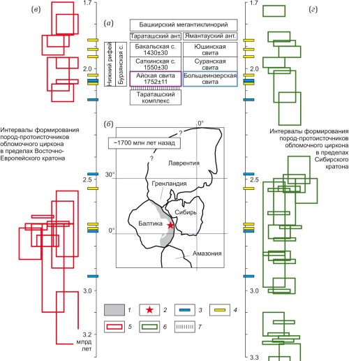
When the maxima on the relative probability density curves of age of detrital zircons from the basal sandstones of the of the Riphean prototype (Ai and Bol’shoi Inzer formations, Southern Urals) are compared with the time intervals of formation of potential detrital zircon sources in the East European and Siberian cratons, ~1.7 Ga ago located immediately west and east of the area of accumulation of sediments originally comprising these formations, it is apparent that they are substantially similar to each other. This suggests that the detritus in the basal strata of the Riphean stratotype could be derived from rock complexes of both cratons. All of the aforesaid may represent an example of the so-called parallel tectonomagmatic evolution of cratons and draw the attention of researchers to the possibility of obtaining multivariate models for the formation of detrital zircon populations in sandstones based solely on U-Th-Pb isotopic dating of detrital zircons.
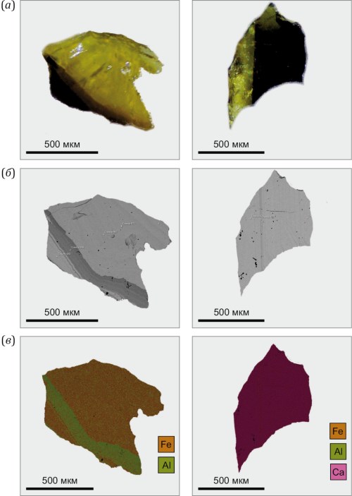
The results presented here concern the U-Pb (ID-TIMS) geochronological studies of garnet from ore-bearing skarns of the Granatovoe deposit (Irba ore field, Eastern Sayan). The studied garnet is represented by polychrome grains. It has been found that the studied garnet is similar in composition to andradite (98–100 %), though some of the parts of the marginal zones show the presence of a grossular component (no more than 5 %). On the boundary of the central zone composed of brown garnet and the periphery of the crystals, there is a zone made up of andradite-grossular garnet, where the aluminum content often exceeds the iron content. Polychrome zonation in garnets from magnetite skarns of the Granatovoe deposit reflects a complex combination of diffusion and infiltration metasomatism. High mobility of iron away from the contact in the early stages of skarn formation gave rise to primary brown andradite in the exoskarn zone. A subsequent increase in metasomatism intensity provided formation of high-aluminous garnet and its growth on early andradite. The granite-hosted molybdenite inclusions are a characteristic feature of the ore association and other iron ore deposits of the Eastern Sayan. Studies have been made of garnet fragments from concentrically zoned polychrome grains. It has been found that the central dark-colored zones of andradite composition are more enriched in uranium (25–29 ppm) than the outer light-colored zones which demonstrate a much lower uranium content (3.5 ppm) and a significant loss of radiogenic lead (Pbc/Pbt=0.67). A thermal effect on garnet during the late metasomatic processes caused diffusion of lead in the outer zones, while the U/Pb system remained almost unchanged in the central parts. The data obtained are the first "direct" age estimate of magnetite mineralization of the Irba ore field (503±6 Ma; MSWD=1.3). Age consistency between gabbroid volcanoplutonic complexes in other areas of the Altai-Sayan region suggests a simultaneous occurrence of the Early Paleozoic iron ore mineralization within the eastern segment of the Altai-Sayan folded region and gives grounds to recognize the iron-ore metallogenic epoch at the accretion-collision stage of the Altai-Sayan folded region development.
RECENT GEODYNAMICS
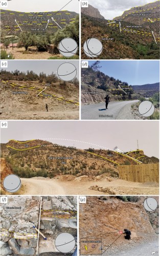
The Azilal Province in the Central High Atlas (Morocco) provides an excellent natural laboratory to investigate how inherited basement structures and Triassic evaporitic décollements interact to control tectonic architecture during intraplate mountain building. Here we integrate gravity-based structural mapping with field structural observations to characterize the dominant structural trends and their crustal significance. We analyze the Bouguer anomaly data from the WGM2012 global gravity model and apply the horizontal gradient magnitude filtration and automatic lineament extraction using the CET grid analysis. The resulting lineament network highlights two principal fault systems trending NE-SW and NW-SE, with subordinate E-W to ENE-WSW lineaments. Euler deconvolution solutions cluster along these trends and indicate source depths of several kilometers, supporting the interpretation of a crustal-scale structural grain. Field observations (fold geometries, fault orientations, and kinematic indicators) corroborate the gravity-derived framework and show that both NE-SW and NW-SE structural families are expressed at the surface. In particular, a major NE-striking normal fault affecting the Toarcian-Bajocian succession records the persistence of inherited extensional discontinuities that influenced basin configuration and subsequent deformation. The spatial association between mapped diapiric belts and gravity-derived structural trends further suggests that salt mobilization was guided by pre-existing fault corridors and facilitated by evaporitic detachments. Overall, the combined geophysical and geological datasets indicate that basement inheritance and evaporite-controlled decoupling exert a first-order control on deformation style, basin segmentation and diapir localization in the Azilal segment, refining regional models for the evolution of the Central High Atlas.
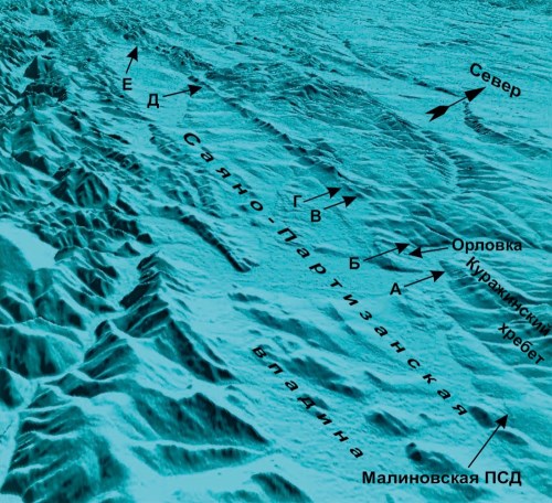
This study investigates seismicity and seismically active structures of the northwestern Eastern Sayan. The relevance of the study stems from the need to reassess seismic potential of these structures after their associated M W=5.5 earthquake of 2000 and the subsequent discovery of a paleoseismic dislocation in the region which is still poorly known. New data were obtained through field surveys, electrical resistivity surveys, and analysis of previously unused materials from regional deep seismic profiles. These data were used to analyze tectonics, geological structure and morphostructural features of the area in relation to seismicity. The results indicate that the areas with the highest seismic potential are the Kingash and Kiyai-Okler faults branching off from the Iya-Kan fault, whose northwestern termination extends into the suburbs of Krasnoyarsk. The Kingash and KiyaiOkler faults are welldefined and control the northeastern margin of the MesoCenozoic SayanPartizansk basin. The study in linear dislocation zones of these faults focused on seismogeological field reconnaissance and geophysical survey. Analysis of the obtained results and geologicalgeophysical data from published literature suggests that the Mana trough serves as a natural northwest-trending boundary for the seismogenic structures on the northeastern slope of the Eastern Sayan. The study demonstrates that the Main Sayan and Eastern Sayan faults do not pose a significant seismic hazard to Krasnoyarsk. The practical significance of the research results lies in refining the structure of earthquake source zones southeast of Krasnoyarsk and resolving contradictions in regional seismicity assessments on General Seismic Zoning (GSZ) maps for recent decades. The GSZ maps may show the Kingash and KiyaiOkler faults as a single earthquake source zone confined to the IyaKan fault system. The potential maximum magnitude of this source zone is estimated at Mₘₐₓ=7.5 along extension. The sourcerelated maximum possible intensity in Krasnoyarsk may reach 7.3 points on the MSK-64 scale.
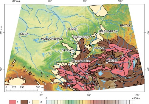
This work presents an analysis of morphometric parameters for low-mountain, mid-mountain, and high-mountain geomorphological formations of the Great Altai, Western Sayan, and Eastern Sayan. The geomorphological formations of the mountain belt are associated with neotectonic blocks that experienced the Late Cenozoic uplift. Anaysis has been made of the morphometric parameters such as absolute elevations, depth and density of dissection, average slope angles, and the degree of preservation of the planation surface (peneplain) formed within the study area prior to the onset of neotectonic activation. The characterization has been performed of criteria for morphometric differentiation between geomorphological formations of the mountain belt. It has been found that the density of dissection does not differ between the different types of formations, whereas all other parameters show a significant difference. The identified similarity in horizontal dissection across different formations suggests that the initiation of the hydrographic network was the early orogenic stages, after which it had continued to develop inheritedly.
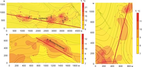
This article provides a geological, geophysical and geochemical description of the Dachnoye hydrothermal deposit (the central part of the Iturup Island, Kuril Islands), located in a zone of the modern tectonomagmatic activity. The results reported in the article describe the detailed thermal and geochemical studies within the deposit. This work presents the sublatitudinal geological and geothermal section of the deposit based on drilling and logging data. A statistical analysis of shallow-depth temperature survey of the deposit in an area of 6 km2 (over 1300 measurement points) allowed us to determine the sites where thermal mineral waters reach the surface and to characterize the tectonic features of the deposit area. Regarding the chemical composition of the waters, this area has a promising potential for balneological development.