


PALEOGEODYNAMICS
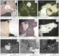
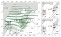
The study of diverse mantle-derived igneous complexes is important for interpreting geodynamic events, ore deposits formation mechanisms, and ore-forming fluid sources. Modern studies of orogenic gold deposits in the Precambrian metamorphosed terranes emphasize the importance of subduction-enriched lithospheric mantle in the ore formation processes. Orogenic gold mineralization in the Nimnyr terrane of the Aldan-Stanovoy shield is confined to the outcrops of mafic granulites from the Medvedev complex, intruded and metamorphosed 1.92–1.90 Ga ago at the final stage of the collision process. The Medvedev complex and ore bodies are intersected by non-metamorphosed dolerites of the 1.87 Ga Timpton-Gynym and 1.75 Ga Timpton-Algamai dike belts formed under conditions of post-collisional and intracontinental extension. The mantle-derived igneous complexes, presenting in a variety of geodynamic settings and ore mineral formation stages, make it possible to identify compositional and evolutionary features of the mantle in connection with ore formation processes. To do this, there were determined rock-forming oxide and trace element concentrations in pre-ore mafic granulites of the Medvedev complex and post-ore dolerites. Based on the geochemical data, there was a reconstruction of rock and mantle source type formation conditions. It was found that the rocks of the Medvedev complex are plume-derived. Doleritic melt formation was contributed to by the subduction-enriched lithospheric mantle material. There is a possility of different degrees of source melting and interaction of plume with the enriched lithospheric mantle at the final stage of the collision process. The obtained results can be used to refine the geodynamic models of gold mineralization formation in the central part of the Aldan-Stanovoy shield. There has been proposed one of the standard models.
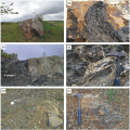
The Alambay ophiolite zone (AOZ) is located in the axial part of the Early Paleozoic Salair orogen and includes the northern extension of the Alambay-Kaim zone, Salair and Altai Mountains. The Shalap area of the AOZ is predominantly composed of clastic mélange with occasional serpentine mélange. The geological and geochemical studies showed that in the Shalap mélange there are basalt blocks of the Alambay formation whose petrogeochemical features are similar to those of the oceanic island basalts (OIB). Metamorphic rocks of the Angurep complex, represented by garnet and non-garnet amphibolites, form a tectonic slab which is a part of the accretionary complex east of the Shalap mélange area. Metamorphic rocks also form blocks in the Shalap mélange. The amphibolites of the Angurep complex are similar in their petrogeochemical features to the basalts of intraoceanic island arcs. The Shalap mélange is a fragment of the Salairian Cambrian paleosubduction zone. The subduction and exhumation processes in this paleosubduction zone terminated by the 500 Ma time stage.

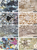
There have been petrographic, geochemical, geochronological (Rb-Sr, Ar-Ar) and isotopic (Sm-Nd) studies done on the metamorphic formations of the Kharamatolou structure of the Polar Urals, which were usually assigned to the Precambrian. The temperatures of metamorphism have been shown to range from 450 to 626 °C, and the pressures – from 3.7–9.1 kbar once PT-conditions reached the amphibolite facies. The amphibolites of the Kharamatolou formation are geochemically divided into two groups. According to the distribution spectra of lanthanides and Nd isotope composition, one group has the characteristics similar to depleted N-MORB basalts εNd(0)=+7.0, and another group – those similar to moderately enriched E-MORB basalts εNd(0)=+(4.5–2.4). It has been found that the Kharamatolou structure is probably composed of the Early to Middle Paleozoic continental rise deposit of the Russian Platform, which passed the main stage of folding and metamorphism in the Late Devonian (Rb-Sr, 366±11 Ma). The gabbro-ultrabasic Ray-Iz and Voykar-Synya massifs have been shown to be one during most of their Pre-Triassic history. Now these ultrabasite massifs are separated by the young (Triassic) Kharamatolou uplift which is an erosive-tectonic semi-window where ultrabasic rocks of the Polar-Ural belt are exposed at the base of the thrust fault. The Kharamatolou structure is one of the transverse uplifts of the Urals which probably resulted from the Middle to Late Triassic compression therealong. As a result of the Middle to Late Triassic uplift of the Haramatolou metamorphites, the overlying ultrabasites were washed away by erosion. The mélange serpentinites observed in the center of the Kharamatolou structure are uneroded remnants of the link that once existed between the Ray-Iz and Voikar-Synya massifs. This significantly increases the metallogenic potential of the Voikar-Synya massif, as the Ray-Iz hosts the largest known chromite deposits in Russia.
This paper presents the results of a study of isotopic systems in minerals and rocks in southern margin of the epi-Archean Karelian craton in the zone of its junction with the Svecofennian mobile belt. U-Pb, Sm-Nd and Rb-Sr mineral ages of metamorphic rocks allowed reconstructing a T-t trend during ~1.88–1.61 Ga, which reflects a wide-ranging cooling history of metamorphic rocks from the peak values of about 650–700 °C at 1.88–1.79 Ga (U-Pb age of monazites and apparent oldest Sm-Nd age of amphiboles) to 300–400 °C at 1.61 Ga (model Rb-Sr age of biotites) in zones of low- and medium-temperature metamorphism. The specificity of removal of deep-seated rocks to the present-day erosion surface and the reconstructed T-t trend comply with the development of thrust-nappe structures during the exhumation of the Svecofennids. It is also assumed that differential vertical block movements played a significant role during the post-orogenic extensional collapse and neorifting.
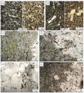
This paper presents the results of isotope-geochronological and petrological studies of gabbroic and combined diorite-granite dikes located in the eastern part of the Kaakhem magmatic area. Both groups of dikes cut through diorite-tonalite-plagiogranite associations of different ages (489±5 and 476±4 Ma). Zircons from granitoid of mingling dikes have an age of 477±3 Ma (LA-ICP-MS). The age of the gabbroic dikes was determined by LA-ICP-MS (zircon) and Ar-Ar (amphibole) methods and is 454±10 and 450±6.3 Ma, respectively. Similar contents of major and trace elements in basic and intermediate rocks of dikes indicate their formation from a single source with subduction characteristics. The salic rocks of the combined dikes vary in composition and are close to the heterogeneous diorite-tonalite-plagiogranite-granite associations of the host rocks. The formation of dike complexes occurred at the collisional stage of development of the Kaakhem magmatic area and is associated with the development of local extension zones.
RECENT GEODYNAMICS
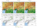
The mechanisms of preparation and occurrence of the strongest deep-focus earthquakes with MW≥8, as well as their surface manifestations, remain insufficiently studied because of the lack of the relevant data. There are but three seismic events of this kind which have so far been instrumentally recorded. This paper describes the identification and analysis of the changes in the characteristics of modern crustal movement of the 2013, MW 8.3 Sea of Okhotsk deep-focus earthquake based on the data from long-term continuous geodetic-class GNSS stations in the Sea of Okhotsk region on the Kamchatka Peninsula, the Sakhalin Island, and the coast of the Sea of Okhotsk and the Sea of Japan. There has been found temporal stability of variations in the average annual geodetic site velocities. The coordinates of GNSS-stations do not show non-linear changes typical of strong shallow earthquakes in the initial post-seismic period. The Maxwell rheology for modeling of viscoelastic relaxation of the asthenosphere/upper mantle as a result of seismic impact allows for a first approximation to qualitatively and quantitatively reproduce the displacement patterns of GNSS-sites of the Kamchatka Peninsula observed in the initial postseismic period (2–3 years after the mainshock). After that, the model estimates of postseismic movements of the peninsula become systematically lower than the observed. The values calculated for the OKHT station motion on the western coast of the Sea of Okhotsk are in good agreement with those recorded for postseismic displacements over the entire measurement interval. The observed directions of the Sakhalin Island postseismic movements systematically deviate to the northeast from the model directions and are oriented almost orthogonally to the Kuril-Kamchatka Trench. Besides the viscoelastic relaxation process, another possible reason for this issue could be an enhanced viscous friction in the bottom of the subducting Pacific plate, leading to the intense deformation of the Sakhalin Island and the western coast of Kamchatka.
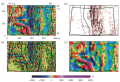
Variations of the LURR (load-unload response ratio) earthquake medium-term forecasr parameter in combination with changes in seismotectonic deformation modes (STD) for the East Anatolian fault region, where catastrophic earthquakes occurred in February 2023 (06.02.2003, MW=7.8, 06.02.2003, MW=7.6) are considered. The depth of the earthquake catalog for the LURR method calculations was equal to 23 years, and estimates of STD modes were possible received since 1976. Calculations have shown satisfactory results in detecting LURR anomalies before strong earthquakes. Almost half of the anomalies occurred in the one and a half year period before the doublet, and are unambiguously associated as precursors. The precursors were recorded by two series of LURR parameter anomalies in 2021 and 2022, and the calculation areas in which they were recorded compactly cover the East Anatolian fault, including the epicenters of the earthquakes on February 6, 2023. The results of calculations using the LURR method were compared with the reconstruction data using the STD method. As a result, it was possible to build the dynamics of the earthquake preparation process in its final part – from the appearance of the LURR anomaly to the earthquake. At the same time, the period before the appearance of anomalies (since the 1976) was also taken into account. It is shown that during the period of abnormal LURR behavior (the forecast period), the most significant changes in the geodynamic regime were observed, as well as a sharp increase in total seismic activity.
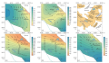
The 800×500 sq km area of the the Middle Urals, Russia, lying between 56 to 60° northern latitude and 54 to 66° eastern longitude, was studied in terms of the deep crustal structure. The study was based on three-dimensional modeling of the sources of magnetic anomalies in three layers of the Earth’s crust. The studied area covers the folded region of the Urals and adjacent structures of the East European Platform and the West Siberian Plate. The sources modeled in the near-surface layer down to a depth of 5 km make it possible to clarify the position of magnetized massifs, mainly consisting of mafic-ultrabasic rocks, and to trace their connection with mafic-ultrabasic belts in the granite layer and root blocks in the lower basaltic layer of the Earth’s crust. When the sources in the upper crustal layer are compared with those in the lower crustal layer, it is apparent that many belts on the platform have deep-seated roots and are located above the basalt layer protrusions, while most of the massifs in the Urals do not have deep-seated roots. The springs located under the western slope of the Urals allow reliably determining the depth to the basement of the ancient platform and the location of the eastern border of the East European Platform in the lower layer of the Earth’s crust. There were found extended zones of subsidence of the roof of the lower magnetized layer, which probably mark the boundaries of various terrains forming the paleo-island arc sector of the Ural fold system. The most extensive subsidence of the roof of the lower layer occurs to the west of the Tyumen-Chudinovsky fault and is perhaps the eastern deep-seated dividing line between the Ural fold system and the West Siberian Plate.
TECTONOPHYSICS
The article describes the methodological basis and some first experience results of applying paleotectodynamic analysis of tectonic movements rank components and deformations to study the features of geological development of a certain territory of the Bukharo-Khiva region central part in the Mesozoic – Cenozoic. The relevance of the work is determined by the need to revise the traditional methods of historical and structural analysis, based on which the conditions of formation and age of oil and gas structural traps are determined to improve the reliability of prognostic works. Paleotectodynamic analysis, as a new direction of studying the geologic evolution history, provides an assessment of the duration of manifestation of tectodynamic systems (paleotectonic stresses, tectonic movements and deformations) of different ranks in geologic history, study of the paleotectonic development of rank components of tectonic movements and deformations in the intervals of tectodynamic system action, determination of the relative age of formation of structural elements, their inheritance, as well as determination of the relative age of formation of structural elements, their inheritance, role or contribution to the geological evolution.The main indicator, on the basis of which the possibility to identify an independent (integral) tectodynamic system is determined, is the stress field type and deformation regime. In the Mesozoic – Cenozoic of the western part of the Tien Shan, five phases of alternating change of tectonic stress fields of the first (for this region) rank and associated deformation regimes were identified. In the first approximation, they correspond to: Early – Middle Jurassic, Late Jurassic, Cretaceous, Paleogene, and Neogene-Quaternary time. On this basis, the paper substantiates the necessity to revise and modify the classical methods of historical-structural (paleotectonic) analysis, which should be performed for each rank component separately, taking into account the interaction of both peer-to-peer and multi-rank elements. In this approach, the most important indicator is the feedback sign between different rank elements of tectodynamic systems. On the example of the central part of the Bukharo-Khiva oil-and-gas-bearing region, paleotectonic maps-schemes of three ranks for the above-mentioned time intervals were obtained. The previously unknown features of the structural plans of different horizons and their evolution in the Mesozoic – Cenozoic history were established. They served as a basis for further traditional historical-structural analysis with the construction of isopachic triangles along the selected intervals for each rank component in order to assess the tectonic conditions and time of formation of anticlinal oil and gas traps.

The western margin of Central Iran – the Nain area – is composed of the Mesozoic ophiolitic mélanges deposited during the Late Cretaceous. The Nain and Darrech Deh faults whose trace indicators can be seen in the study area are among the largest faults therein. These faults have a north-northwest strike and are the right-lateral transpressional active lineaments. The main aim of this research is to perform structural mapping and geometric analysis of structural features along the Nain and Darrech Deh fault system. The research was conducted using satellite imagery and field data. The structural analysis showed that the faults comprise a complex network which formed during two stages: 1) thrust faulting in the Late Cretaceous and 2) reactivation of thrust faults in the form of the right-lateral reverse-slip structures as a result of transpressional movements in the Upper Miocene. The Nain and Darrech Deh faults are presently active and exhibit the right-lateral strike slip displacement with a reverse component.


