


PALEOGEODYNAMICS

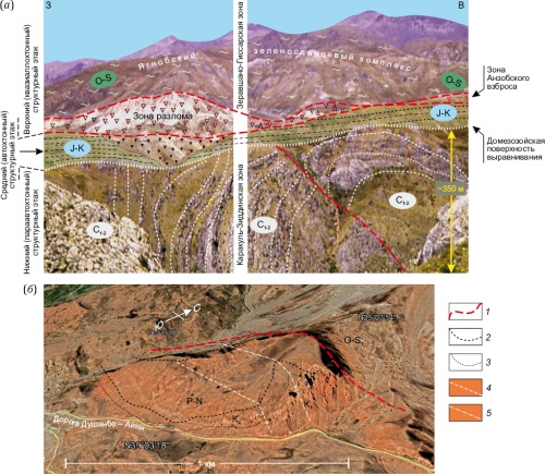
The synthesis and analysis of new geological and geophysical data through the Black Sea-BalkanAnatolian-Caspian megaregion been appeared during the last two decades have been carried out. All collected materials make it possible to give a completely different interpretation of long-known facts and to provide a new-level consideration of the onset time and mechanism of the Greater Caucasus uplift, as well as genetic type and filling mechanism of the Ciscaucasia troughs. It has shown that the Greater Caucasus orogen became a high and an intensively eroded mountain structure not earlier than the Pliocene. Its formation was not due to the Oligocene (or earlier) initiation of long-term tectonic near-meridional crustal shortening and slow gradual uplift, but occurred as a rapid uplift of the crustal block in the Pliocene – Quaternary in response to the delamination of a fragment of the lithosphere beneath the central part of the Caucasus region. The modern geomorphological appearance of the Greater Caucasus orogen was greatly contributed to by the deformations originated from large-amplitude right-lateral strike-slip movements with additional transpression along the regional Crimea-Caucasus-Kopetdagh fault zone, as well as from the gravitational collapse of the orogen. Most of the Cenozoic sediments, filling the Ciscaucasia troughs, have accumulated in the basin located in the northeastern part of the Eastern Paratethys. Until the Pliocene this basin was a pericratonic sedimentary basin on the southern shelf of Northern Eurasia, which experienced the accumulation of sediment transported primarily from the ancient East European and young epi-Hercynian Scythian platforms. The sedimentary basin, with relics as the Ciscaucasia troughs in the present-day structure of Ciscaucasia, was separated from the Eastern Paratethys by the rapidly uplifting Greater Caucasus orogen at the very end of the Pliocene – Quaternary and transformed into a piedmont trough wherein the sediment from the GC started to accumulate.
Negative structures of the Earth’s crust, including intermountain and intramountain basins, are key sources of information on the formation of the continental crust through plate tectonic and orogenic cycles. The aim of the work is to give a comparative description of the Mesozoic-Cenozoic basins of the Eurasian intracontinental orogen and to identify regional features of the geodynamic development of its various segments. The object of the study is the Mesozoic-Cenozoic intramountain basins of the Gissar-Alai mountain system (Western Tien Shan), Central Tien Shan, and Western Transbaikalia. The research methodology included comparative geological analysis, structural and tectonic research, geomapping of key areas, description of lithological sections, experimental tectonophysics, magnetotelluric sounding, etc. The first article of the series shows that the Mesozoic and Cenozoic territory of the Western and Central Tien Shan was a zone of dispersed shear flow. These were the conditions in which a system of intramountain depressions and their separating uplifts was formed and evolved. It has been found that the movements of rock masses in the "depression/uplift" system were caused by the redistribution of rock masses during their rheid deformation under conditions of vertical and lateral rheological heterogeneity of the crust. The second article of the series will present a description of the depressions in Western Transbaikalia, discuss the material, and formulate conclusions on the research problem.
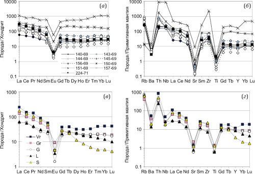
The paper deals with the petrogeochemical composition and U-Pb (SHRIMP-II) age (753±6 Ma) of subalkaline leucogranites and syenites from the Khariusikha massif of the Yenisei Ridge, which contain rare-metal mineralization. High trace-element concentrations (%) – Nb (0.5–0.7), Ta (0.12–0.16), REE (0.08–0.24), Y (0.06–0.10), Zr (2.3–2.6), Hf (0.10–0.12), U (0.05–0.10) and Th (0.08–0.10) – are confined to albitized granites. Synthesis information on age and composition of rhyolites of the bimodal volcanic associations of the Upper Vorogovka and Glushikha troughs and subsynchronous granitoids of the Trans-Angarian Yenisei Ridge indicates A-type granitoids. Their formation is limited to 750–720 Ma interval and is temporally correlated with the formation of a Late Neoproterozoic large igneous province whose ultrabasite-basite magmatism is localized along the present-day southern flank of the Siberian Platform. The considered volcanic and intrusive rocks are characterized by wide-range high field strength element concentrations and εNd(t) values ranging from –9.2 to +0.7. Crustal sources are dominant for most of the felsic magmatic rocks. A probable contribution of the mantle source to felsic magmas generation is evidenced by more radiogenic Nd isotope composition and enrichment of the Khariusikha massif granites and syenites in high field strength elements, as well as by the similarity of the Upper Vorogovka trough basalts with OIB.

Studies have been made on pyroxene (Cpx) and garnet (Grt) megacrysts from the rocks related to two-stage formation of the Tesiingol volcanic field in Northern Mongolia. The rocks related to the initial stage of the volcanic field formation, basanites and phonotephrites of the Early Miocene Bod-Uul volcano (40Ar/39Ar, 17.0±0.5 Ma), do not contain xenogenic material. Megacrysts and associated peridotite and pyroxenite xenoliths were discovered in eruptive deposits and lavas of basaltic trachyandesites of the Middle Miocene Uguumur volcano (40Ar/39Ar, 12.5±0.2 Ma) at the second stage of activity. The volcanic field rocks show the presence of carbonate matter. Cpx and Grt megacrysts have traces of melting and transformation and are associated with sanidine, ilmenite and apatite megacrysts. Pyroxenes have elevated contents of Al and Na and are similar in composition to omphacites (Di71–72Jd16–19Ae9–12). Garnets are characterized by chromium-free almandine-grossular-pyrope composition (Alm58–66Grs17–20Pyr14–19) and correspond to minerals of eclogite paragenesis. Pyroxene megacrysts, compared in composition to pyroxenes from eclogites and peridotites, are enriched in REE, Y, Nb, Ta and Hf. Garnets show relatively high contents of LREE, Zr and Hf. It has been found that the early-stage basanite and phonotephrite magmas were formed in the asthenospheric mantle at 21–28 kbar and 1359–1432 °C. The formation of basaltic trachyandesite melts occurred near the crust and upper mantle at 10–13 kbar and 1192–1237 °C. Megacrysts of the Cpx+Grt association crystallized at 20–24 kbar and 1190–1331 °C in the area of the garnet facies of the lithospheric mantle depth and near its boundary with the asthenosphere. Based on the data for P-T formation conditions, crystal chemistry, trace element and isotopic composition of Cpx and Grt megacrysts, a model of the origin of the latter has been proposed. It is suggested that megacrysts formed above the deep magma chamber as a result of the process similar to pneumatolytic, due to the separation and subsequent crystallization of a silicate-carbonate phase above the solidus of carbonated peridotites, mainly in the lithospheric mantle.
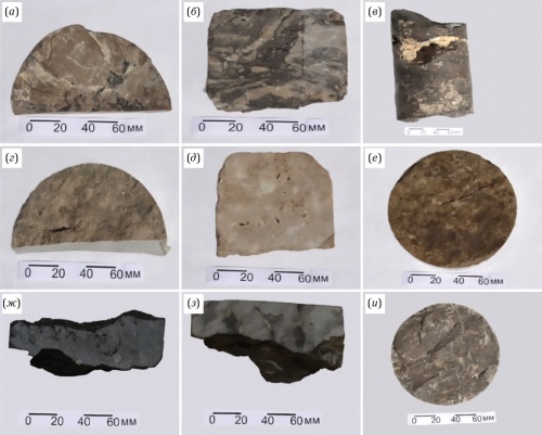
The Northwestern marginal fault zone is a part of the Caspian Basin and a boundary transition structure separating the basin from the Volga-Ural region. It has been found that this fault zone is characterized by a complex kinematic development leading to the formation of a linear salt-dome structure. Research has been carried out on deformation changes in the Famennian-Tournaisian carbonate rocks in the Northwestern marginal fault zone. A set of macro- and microscopic studies made it possible to assess the nature of deformation changes, the state of structural and textural maturity, the composition of the original rocks, as well as to identify the composition of secondary minerals and void space and determine the kinematic types of tectonic fractures formed therein. The recognition of carbonate mineralogical varieties has been performed by the method of thin section staining with alizarin red, which made it possible to distinguish between calcite and dolomite and to determine their quantitative ratio in thin sections. The carbonate samples were studied by X-ray diffraction, and thermal and probe methods, which revealed the features of the crystalline phase and accessory impurities and provided a characterization of the crystalline structure of minerals. Analytical studies made it possible to identify thermally inert formations of calcium, magnesium, silicon and iron oxides and other compounds in carbonates and to determine the nature of deformation changes in the Famennian-Tournaisian carbonate reservoir rocks.
RECENT GEODYNAMICS

This study investigates the configuration of sedimentary basin in Lampung area, the southeastern part of the Sumatra Island, using integrated gravity and seismic data. This research aims to enhance the understanding of sedimentary basin structures, focusing on the identification and delineation of sub-basins, basement highs, and fault systems. Gravity data analysis, including Bouguer anomaly mapping and spectral analysis, was used to estimate the depth of sedimentary layers and the configuration of the basement. Seismic data provided direct observations of subsurface reflectors, aiding in the identification of fault structures and stratigraphic continuity. The integration of both datasets allowed for the creation of a detailed geological model of the basin, supported by well log data from wells LPG-1, LPG-2, and LPG-3.
The study identified seven major sedimentary sub-basins, among which are Negara Batin, Menggala, East Menggala, Terbanggi, Metro, and Kotabumi. Forward modeling results indicate that the Terbanggi sub-basin is the deepest, with a maximum depth of approximately 3 kilometers. The presence of volcanic material, particularly tuffaceous sandstone and tuff breccia in the Lower Lahat and Baturaja formations, was confirmed through well and seismic data, highlighting the interaction between volcanic and sedimentary processes in the basin’s evolution. This integrated approach provides a more accurate understanding of the basin’s geometry and structural features, offering valuable insights into the tectonic history of the region.
The findings contribute to future geological studies and exploration efforts, demonstrating the effectiveness of combining gravity and seismic data in analyzing complex subsurface environments.
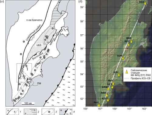
The paper deals with the study of the deep structure of the Earth’s crust and upper mantle in the eastern part of the Kamchatka Peninsula. One-dimensional sections have been constructed to illustrate the relationship between shear wave velocity VS and depth h, obtained by inversion of longitudinal receiver functions, computed from seismograms of distant earthquakes recorded at 11 seismic stations of the KB FRC GS RAS for the period 2011–2016. The study presents a two-dimensional VS-model to a depth of 70 km for a profile along the 950-km East Kamchatka volcanic belt.
The constructed sections reveal a layered structure of the crust and ~40 km of the subcrustal mantle, which can roughly be described as a layered-block structure. The following structural layers are distinguished within the Earth’s crust: contrasting boundary at a depth of 5–7 km with a 2.8 to 3.2 km/s leap in transverse wave velocity; homogeneous layer at a depth of 10–25 km with a smooth VS increase from 3.5 to 3.7 km/s; transitional crust-mantle zone at a depth of 28–36 km with VS=3.8–3.9 km/s. The upper mantle layers are referred to as low velocity layers (VS=4 km/s) relative to IASP91 global model. The velocity profile from the Avacha Bay area reveals a complex crustal structure; velocity anomalies found at depths of up to 25 km are most likely a reflection of the Petropavlovsk-Malki zone of transverse dislocations, which is the conditional boundary between the structures of Southern and Central Kamchatka.
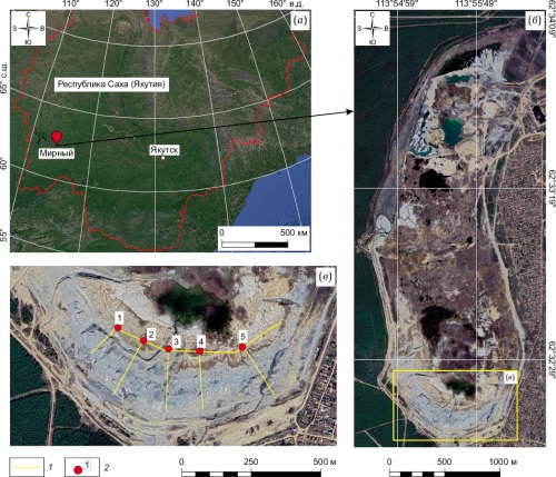
The occurrence and development of exogeodynamic processes caused by liquefaction and fluidity of deposits that comprise the mine tailings dam may provoke emergency situations (breakthroughs). To prevent such situations, objects like these are covered by regular geomonitoring.
The article presents the results of the study of the current state of the technogenic tailings dam deposits of the enrichment factory No.3 of the MPP (Mirny, Yakutia). Severe climatic, structural-geological and permafrost-hydrogeological conditions of the study area, as well as the thawed state of the technogenic strata (+0.5 to +3.1 °C) require to carry out a thorough control over the state of the dam in order to ensure its effective and safe operation.
Studies of the material composition and properties of technogenic deposits were carried out based on the data on five drilled 31–58 m deep boreholes and sampling intervals. The granulometric and mineralogical compositions, as well as physical, physical-chemical and mechanical properties were determined according to standard methods using modern equipment (Analysette 22 NanoTec granulometric analyser, automated test complex ASIS).
It has been found that the technogenic strata are layers of loose rock represented mainly by silty-clayey (sandy loam, loam and clay), less often by sandy material. Most of the clay varieties transform from solids to fluid-plastics. The most common lithological variety is silty loam, comprising ~40 % of the total volume sampled. The mineral composition of sediments is characterized by a high content of dolomite, calcite, quartz, serpentine and clay minerals. All clay deposits types have been found to have low strength (C=0.003–0.050 MPa, φ=3.9–15.7°) and high deformability (E=1.6–5.6 MPa). They also exhibit "dangerous" process-forming properties – plasticity, fluidity and flowability, which give rise to the development of exogenous geological processes (erosion, slumps, landslides, etc.), and consequently, influence the stability of the mine tailings dam.


