


Contents
Scroll to:
https://doi.org/10.5800/GT-2025-16-5-0853
EDN: buaaty
Scroll to:
The parameters of earthquakes recorded in the Arctic region during the early 20th century and calculated by researchers in the first half of the century continue to be used in modern seismic event catalogs. However, these hypocentral parameters are predominantly computed based on bulletins compiled only from a subset of the seismic stations operated during that period, utilizing outdated velocity models and location algorithms, which restricts their accuracy and reliability.
This study presents a consolidated catalog of all earthquakes recorded between 1900 and 1950 within the geographic region bounded by 70.0° to 90.0° N latitude and 70.0° E to 170.0° W longitude. Using the most comprehensive set of instrumental data, a modern velocity model, and a location algorithm adapted for early instrumental earthquakes, a refined catalog of earthquakes was compiled for the eastern sector of the Russian Arctic during the first half of the 20th century. Additionally, a secondary catalog was developed for earthquakes attributed to the region in various sources. However, after recalculating the epicentral coordinates, these events were excluded from the considered area. A total of 19 earthquakes were recorded within the study area, with magnitudes (Mw) ranging from 5.2 to 6.9, primarily associated with the Gakkel Ridge and its continuation on the Laptev Sea shelf, as well as the continental portion of northern Yakutia. The results of this study can be used to refine seismic regime parameters, develop geodynamic models, and investigate the stress–strain state of the Earth’s crust. Furthermore, these results may be applied to address safety concerns in the operation of industrial systems and facilities during the exploration of major deposits in the eastern sector of the Russian Arctic.
Morozov A.N., Vaganova N.V., Asming V.E. EARTHQUAKES IN THE EASTERN SECTOR OF THE RUSSIAN ARCTIC IN THE FIRST HALF OF THE 20TH CENTURY. Geodynamics & Tectonophysics. 2025;16(5):0853. https://doi.org/10.5800/GT-2025-16-5-0853. EDN: buaaty
Throughout the instrumental period, the Arctic was inadequately and unevenly covered by permanent seismic stations, primarily due to challenging climatic and geographical conditions, as well as historical and economic factors. The development of instrumental observations was uneven both temporally and spatially. These factors directly influenced the extent of seismological studies in the Arctic regions [Hodgson et al., 1965; Avetisov, 1996; Schlindwein et al., 2015].
To assess seismic hazards, the earthquake catalog is the primary source upon which seismic regime parameters are based. In the Arctic region, information on historical and paleo-earthquakes is limited, making the accuracy of calculated earthquake parameters throughout the instrumental period particularly critical. However, only a small number of stations, often far from the epicenters, recorded the Arctic earthquakes throughout the 20th century. Moreover, the calculation of earthquake parameters was performed using outdated velocity models and location algorithms. Bulletins from all seismic stations operating in the region during that time were also not fully accessible to seismologists [Morozov, Vaganova, 2024].
The development features of instrumental observations and the necessity to assess potential natural and technological risks, as well as to ensure safety during the exploration of large deposits in the Arctic, requires summarizing and recalculating source parameters of earthquakes recorded throughout the instrumental observation period, particularly for the first half of the 20th century. These research activities must employ new and validated regional and global velocity models, modern location algorithms, and all available current data and bulletins from seismic stations that operated in the region [Morozov et al., 2022].
Earlier studies have been conducted for the Arctic earthquakes recorded in the first two decades of the 20th century [Morozov et al., 2019] and for earthquakes in the western sector of the Russian Arctic throughout the entire instrumental period [Morozov et al., 2023]. This article presents the results of creating a consolidated and recalculated catalog of earthquakes for the eastern sector of the Russian Arctic in the first half of the 20th century. The ultimate goal of this study is to supplement the GS RAS and the IEPT RAS earthquake catalog for the Arctic zone of the Russian Federation for the period 1962–2022 [Gvishiani et al., 2022; Vorobieva et al., 2023a, 2023b] with consolidated and recalculated data on the Arctic earthquakes recorded from 1900 to 1962. This study builds upon the methodological approaches and materials outlined in the doctoral dissertation [Morozov, 2024].
Based on data from various sources, as shown in Fig. 1, preliminary information was gathered for all earthquakes recorded between 1900 and 1950, with epicenters located within the following coordinates: 70.0° to 90.0° N latitude and 70.0° E to 170.0° W longitude. Using this information, a preliminary consolidated catalog of earthquakes was compiled for the eastern sector of the Russian Arctic for the period 1900–1950, as presented in App. 1, Table 1.1.
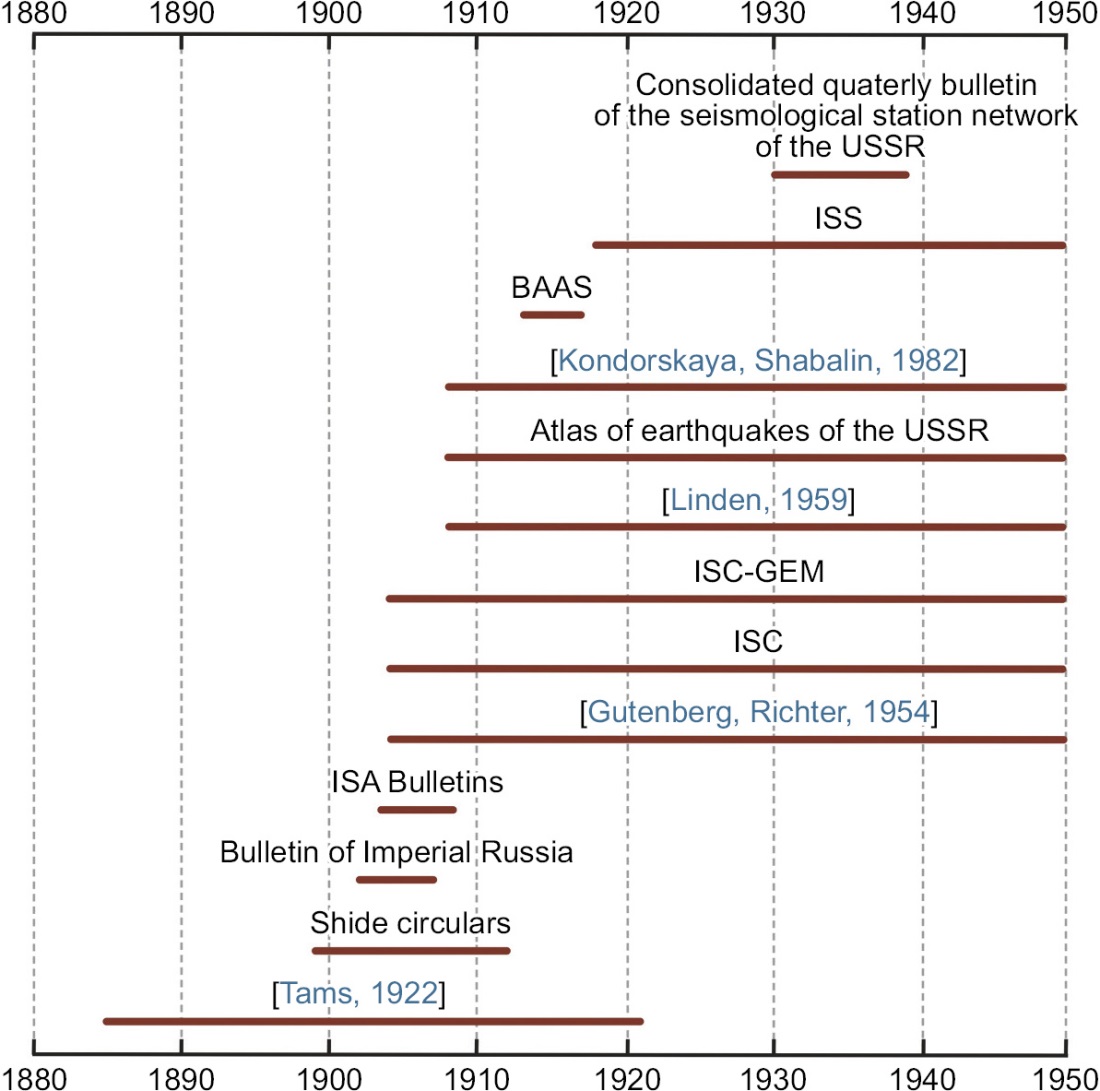
Fig. 1. List of sources used for searching information on earthquakes recorded in the eastern sector of the Russian Arctic during the first half of the 20th century.
Рис. 1. Источники, использованные при поиске сведений о землетрясениях восточного сектора российской Арктики в первой половине ХХ в.
Phase arrival times were identified for each earthquake based on the bulletins from seismic stations that were operating during the first half of the 20th century. Bulletin searches were conducted in archives compiled as part of major scientific initiatives, including the ISC-GEM (International Seismological Centre Global Earthquake Model) project [Storchak et al., 2013, 2015] and the "EuroSeismos" project [Michelini et al., 2005]. Scanned copies of International Seismological Summary (ISS) bulletins, published on the website of the International Seismological Centre (ISC) (https://storing.ingv.it/ISS/index.html) [ISC Bulletin, 2025], were also utilized.
Recalculation of the parameters of the Arctic earthquakes was performed using the NAS (New Association System) software [Fedorov et al., 2019; Asming et al., 2021], which is part of the NSDL (New System for Detection and Location) software suite developed at the Kola Branch of the Geophysical Survey of the Russian Academy of Sciences. The NAS software incorporates a novel event location algorithm that combines two methods: the maximization of a ranking function over a spatial grid – an enhancement of the Generalized Beamforming method [Ringdal, Kværna, 1989] – and the minimization of residuals in origin time estimation.
The NAS algorithm includes several features particularly useful for recalculating the parameters of early instrumental earthquakes based on bulletins from seismic stations of the beginning of the 20th century. First, it automatically disregards erroneous phase arrival times that may result from operator mistakes or instrument malfunctions. Second, it is capable of phase identification in cases where arrival times are listed in the bulletins without phase labels – an issue frequently encountered in early seismological records.
For earthquake location, use has been made of the global velocity model ak135 [Kennett et al., 1995; Kennett, 2005]. Due to the limited number of seismic stations and their significant distance from most of the epicenters, depth determination was not feasible for the majority of events. Consequently, epicenter coordinates were generally calculated using a fixed depth of 10 km. However, the earthquake hypocenter cannot lie above a certain minimum depth (Hmin), which is dependent on its magnitude. Therefore, if the Hmin value for a given event exceeded 10 km, the calculation was performed assuming a fixed depth of 15 km. The minimum possible depth of the earthquake source was determined from its magnitude according to the relationship proposed by [Riznichenko, 1979]:
M≤3.3lgH+3.1. (1)
We recognize that the use of fixed depths (10 or 15 km) introduces additional uncertainty into the hypocenter locations. However, test relocations with alternative fixed depths (10, 15, and 20 km) demonstrated that the resulting epicenter shifts generally do not exceed the size of the formal error ellipses. Thus, while focal depths remain poorly constrained, the epicentral coordinates and their tectonic interpretation can be considered robust within the stated uncertainties.
For some earthquakes, the range of possible depths calculated by the NAS algorithm is indicated in the final catalog, with the depth corresponding to the maximum value of the ranking function shown in parentheses. Epicenter coordinates for those depths were then computed.
The magnitude of an earthquake is one of the fundamental parameters used in seismic catalogs. In the final catalog, priority was given to moment magnitudes (Mw) calculated in the ISC-GEM catalog [Storchak et al., 2013, 2015]; the second-priority magnitudes (MLH) were provided in the catalog compiled by [Kondorskaya, Shebalin, 1982]. MLH magnitudes, analogous to surface-wave magnitudes (MS) and computed at the Geophysical Survey of the Russian Academy of Sciences, were then converted to Mw using the empirical relationships derived in [Petrova, Gabsatarova, 2020].
In cases where earthquake magnitudes could be recalculated using data from a larger number of seismic stations, the Prague formula was applied to compute MS values [Vaněk et al., 1962]. Amplitude values and their corresponding periods in the range of 10 to 60 seconds for epicentral distances between 20 and 160° were extracted from seismic station bulletins and used to calculate MS according to the following formula:
 (2)
(2)
We acknowledge that the conversion of MLH magnitudes into Mw using empirical relationships [Petrova, Gabsatarova, 2020] inevitably introduces some uncertainty, particularly for historical events with limited station coverage. These conversions, however, were employed only when Mw values from the ISC-GEM catalog were not available. Whenever sufficient amplitude–period data could be obtained from a broader station network, MS values were recalculated with the use of the Prague formula.
The principal results of this study, aimed at recalculating the parameters of earthquakes in the eastern sector of the Russian Arctic, are presented in two catalogs (App. 1, Table 1.2, 1.3). The first catalog is a consolidated, refined, and unified list of earthquakes that occurred in the eastern sector of the Russian Arctic during the period 1900–1950. It includes 19 events with moment magnitudes (Mw) ranging from 5.2 to 6.9. For two of these earthquakes, the available seismic station bulletins lack the amplitude values and their corresponding periods required for calculating the surface-wave magnitude (MS). The final catalog provides hypocentral parameters, error ellipses, characteristics of the input data, and both calculated and unified magnitude values (App. 1, Table 1.2).
The second catalog comprises six earthquakes, which, according to various sources, had previously been attributed to the study area, but whose epicenters were further found as lying beyond its boundaries (App. 1, Table 1.3). This catalog also includes the earthquake of March 26, 1927. The phase arrival times, available at that time from seismic stations SVE (Sverdlovsk), TIF (Tiflis), BAK (Baku), and TAS (Tashkent), did not provide a basis for computing the epicenter. This may be due to significant timing errors exceeding acceptable limits, or the arrival times may correspond to different seismic events. The "Notes" column in App. 1, Table 1.3 provides explanations for the inclusion of each earthquake in this catalog.
For several earthquakes in the final catalog, the epicentral error ellipses cover relatively large areas. This is primarily due to the limited number of available seismic stations, their considerable distances from the epicenters, and the narrow azimuthal coverage. Nevertheless, the large size of these error ellipses does not hinder the reliable association of the calculated epicenters with specific seismically active zones.
According to various sources, there were 26 earthquakes recorded within the study area in the first half of the 20th century. Only 19 of those were attributed to the study area after recalculating the epicenter coordinates (Fig. 2). The epicenters of six earthquakes shifted beyond the study area. For one earthquake, the location procedure could not be performed due to insufficient initial data.

Fig. 2. Map of earthquake epicenters in the eastern sector of the Russian Arctic.
Red circles show the recalculated earthquake epicenters from App. 1, Table 1.2. Black circles show the original earthquake epicenters according to different sources from App. 1, Table 1.1. The red line indicates the study area.
Рис. 2. Карта эпицентров землетрясений восточного сектора Российской Арктики за период 1900–1950 гг.
Красные кружки – пересчитанные эпицентры по данным Прил. 1, табл. 1.2. Черные кружки – исходные эпицентры по данным различных источников (Прил. 1, табл. 1.1). Красная линия – граница района исследования.
Of the 19 earthquakes, only 17 were reported in [Kondorskaya, Shebalin, 1982], 12 in [Gutenberg, Richter, 1954], 16 in the ISS (International Seismological Summary) bulletins and [Linden, 1959], and 9 in the ISC-GEM catalog [Storchak et al., 2013, 2015]. Two earthquakes, of August 11, 1924, and August 10, 1949, are not included in [Kondorskaya, Shebalin, 1982], possibly due to the lack of the data required for calculating their magnitudes. In this study, it was also not possible to find the amplitude and surface-wave period values for these earthquakes in the seismic station bulletins. Four earthquakes (June 2, 1928; August 16, 1928; June 20, 1931; September 26, 1948), attributed to the study area according to [Kondorskaya, Shebalin, 1982], were excluded from the analysis (App. 1, Table 1.3).
[Gutenberg, Richter, 1954] suggested that all 20th century worldwide M≥7.0 earthquakes were recorded. [Wetmiller, Forsyth, 1978] concluded that this statement also applies to the Arctic, noting that by the 1940s, earthquakes with magnitudes M=6.0 had been recorded in the Arctic region. [Avetisov, 1996] estimates the representative magnitude values for the Arctic territories during this period as M=5.5–6.0. The earthquakes recorded in the Arctic region by the 1940s were measuring M=6.0, and those recorded from the mid-1950s were measuring M=5.0 [Wetmiller, Forsyth, 1978]. According to [Morozov et al., 2019], from 1904 to 1911, global network stations could record the Arctic earthquakes with magnitudes (Mw) no lower than 6.0, and from 1911 onwards – those with magnitudes (Mw) no lower than 5.0.
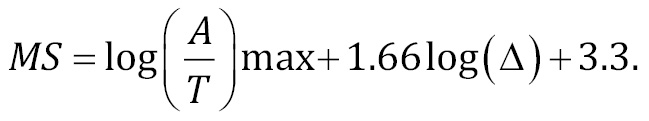
Earthquakes with magnitudes (Mw) no lower than 5.4 were recorded in the study area until 1928. Earthquakes with magnitudes no lower than 5.2 have been registered there since 1948 (Fig. 3, a). From 1929 to 1948, there were no earthquakes recorded within the study area. The distribution of earthquakes by magnitude is presented in Fig. 3, b. Based on this figure, it can be inferred that the representative magnitude (Mw) for this region in the first half of the 20th century did not exceed 6.0.
Fig. 3. Data analysis from the final earthquake catalogue.
(a) – distribution of the recorded-earthquake magnitudes by year; (b) – distribution of the recorded-earthquake number by magnitude (Mw); (c) – minimum distance to the nearest seismic station for earthquakes recorded during different time periods; (d) – number of stations that recorded earthquakes as a function of magnitude.
Рис. 3. Анализ данных итогового каталога землетрясений.
(a) – распределение магнитуд зарегистрированных событий по годам; (b) – распределение количества землетрясений по значениям магнитуды (Mw); (c) – минимальное расстояние до ближайшей сейсмической станции для событий, зарегистрированных в разные периоды; (d) – число сейсмических станций, зарегистрировавших землетрясения, в зависимости от магнитуды.
The distribution of earthquakes over time is highly irregular (Fig. 3, a). The first earthquake recorded in the study area occurred on April 10, 1909 in the eastern part of the Gakkel Ridge near the continental slope of the Laptev Sea shelf and had a magnitude of Mw=6.7. From 1923 to 1928, the highest number of earthquakes (N=13) was recorded during the entire period under review. This may be related to a decrease in the earthquake-recording threshold during this period, as the operation of seismic stations in the USSR gradually resumed after the Civil War, and the number of seismic stations in neighboring countries increased. However, it is also likely that this period represents a phase of increased seismic activity in the region.
Between 1929 and 1948, there was a complete absence of recorded earthquakes. While the lack of recorded earthquakes from 1939 to 1945 can be attributed to the events of World War II and the corresponding reduction in the number of operational seismic stations in Europe and Asia, the absence of recorded earthquakes between 1929 and 1939 remains difficult to explain. A similar situation is observed in the western sector of the Russian Arctic [Morozov et al., 2023]. It is possible that during that period we observe a decrease in regional seismic activity after its increase in the 1920s.
Overall, refining the earthquake epicenter coordinates involved the data from varying numbers of seismic stations (Fig. 3, c), often located at significant distances from the epicenters (Fig. 3, d) and within a wide azimuthal gap. This was primarily due to the specific characteristics of instrumental observations in the early 20th century [Morozov, Vaganova, 2024].
Within the oceanic part of the study area, most of the epicenters of instrumentally recorded earthquakes are located along the ultraslow spreading Gakkel Ridge and its continuation on the Laptev Sea shelf, which forms part of the boundary between the Eurasian and North American lithospheric plates (Fig. 4). On the continent, the region of the Lena River delta shows elevated seismic activity, where most earthquakes are concentrated near the Leno-Anabar marginal fault, which marks the boundary of the Precambrian Siberian Platform and the Chersky Ridge (boundary between the Eurasian and North American lithospheric plates). A series of strong earthquakes occurred in the northern part of Yakutia along the Verkhoyansk Ridge in 1927 and 1928.
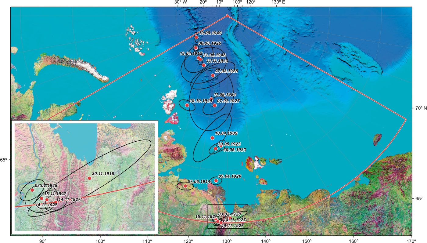
Fig. 4. Map of recalculated earthquake epicenters in the eastern sector of the Russian Arctic for the period 1900–1950 (App. 1, Table 1.2) and their error ellipses. The red line indicates the study area.
Рис. 4. Карта уточненных эпицентров землетрясений восточного сектора Российской Арктики за период 1900–1950 гг. (Прил. 1, табл. 1.2) и их эллипсы ошибок. Красная линия – граница района исследования.
No earthquakes were recorded on the shelf of the East Siberian and Chukchi Seas, as well as in the adjacent areas and the Taimyr Peninsula. Within the continental shelf, only one earthquake was recorded on October 19, 1924 near the Severnaya Zemlya (Fig. 4). The magnitude (MS) of this earthquake was calculated based on the data from four seismic stations (App. 1, Table 1.4). The magnitude was estimated using the Prague formula (2) in a manner similar to the approach in [Ambraseys, Douglas, 2000], by vector summing the maximum amplitudes of surface waves from two horizontal components and the period corresponding to the maximum amplitude. If the data from the second horizontal component were unavailable, then the amplitude from the first horizontal component was the only one used for the MS magnitude calculation, with an additional correction of 0.1 to the calculated magnitude, as per [Ambraseys, Douglas, 2000] to account for the missing information.
The parameters of earthquakes recorded in the Arctic in the early 20th century, and subsequently calculated by researchers during that period continue to be used in modern earthquake catalogs. However, these parameters were often determined using data from only a subset of seismic stations that operated in the early 20th century, employing outdated velocity models and location algorithms.
This article presents a consolidated earthquake catalog for the period from 1900 to 1950 within the geographic coordinates of 70.0° to 90.0° N latitude and 70.0° E to 170.0° W longitude, compiled from various sources. The most complete set of instrumental data, a modern velocity model, and a location algorithm, optimized for early instrumental earthquakes, were used to compile an updated catalog of earthquakes for the eastern sector of the Russian Arctic in the first half of the 20th century. A separate catalog was compiled for earthquakes attributed to the study area in various sources but excluded therefrom after recalculating the epicenter coordinates. For the majority of these earthquakes, the refined epicenter coordinates significantly differ from those provided in the original sources.
A total of 19 magnitude Mw 5.2 to 6.9 earthquakes were recorded within the study area, primarily attributed to the Gakkel Ridge and its continuation on the Laptev Sea shelf, as well as the continental part of northern Yakutia. The four-stations-based recalculation of MS magnitude of the October 19, 1924 earthquake, recorded near the continental slope of the Severnaya Zemlya, yielded a value of 5.6. This value exceeds the catalog magnitude by more than one unit [Kondorskaya, Shebalin, 1982]. No earthquakes were recorded on the shelf of the East Siberian and Chukchi Seas, as well as in the surrounding areas.
An analysis of the distribution of earthquake epicenters over time reveals a 1923 to 1928 high seismic activity period, during which 13 out of 19 earthquakes were recorded. This was followed by a 1929 to 1948 seismic inactivity period, during which no earthquakes were recorded.
The results described herein may serve as a foundation for future research related to the assessment of potential natural and technogenic risks, as well as seismic hazards in the Arctic and surrounding areas. They could contribute to the refinement of the parameters of seismic regime, to the development of geodynamic models, and to the analysis of the stress-strain state of the Earth’s crust. Furthermore, these findings may be utilized to address challenges associated with ensuring the safe operation of industrial systems and facilities during the exploitation of major deposits in the eastern sector of the Russian Arctic.
The authors express their gratitude to the staff members of the RAS GC Archive for their help in the search for the bulletins of the Russian seismic stations.
All authors made an equivalent contribution to this article, read and approved the final manuscript.
The authors declare that they have no conflicts of interest relevant to this manuscript.
Table 1.1. Preliminary consolidated catalog of earthquakes in the eastern sector of the Russian Arctic for the period 1900–1950
Таблица 1.1. Сводный предварительный каталог землетрясений восточного сектора Российской Арктики за период 1900–1950 гг.
|
No |
Data dd. mm. yyyy |
Time hh:mm:ss. 0 |
Hypocenter |
Magnitude* |
Source |
||
|
φ, ° |
λ, ° |
h, km |
|||||
|
1 |
10.04.1909 |
18:46:54.0 |
77.5 |
128.0 |
35 |
M(GUTE)=6.6 MS(PAS)=6.6 M=6.5 MLH=6.8 Mw(ISC-GEM)=6.7 |
[Gutenberg, Richter, 1954] |
|
18:46:58.0 |
78.0 |
128.0 |
– |
[Linden, 1959] |
|||
|
18:46:58.0 |
78.0 |
128.0 |
20 |
[Kondorskaya, Shebalin, 1982] |
|||
|
18:46:54.3 |
78.54 |
129.16 |
10f |
ISC-GEM Catalog |
|||
|
2 |
13.04.1912 |
02:40:00.0 |
86.4 |
94.6 |
– |
MS(PAS)=5.6 M=5.0 MLH=5.2 |
[Tams, 1922] |
|
02:39:42.0 |
80.0 |
100.0 |
35 |
[Gutenberg, Richter, 1954] |
|||
|
02:39:36.0 |
78.9 |
107.9 |
– |
[Linden, 1959] |
|||
|
02:39:36.0 |
78.9 |
108.0 |
20 |
[Kondorskaya, Shebalin, 1982] |
|||
|
3 |
07.06.1914 |
16:24:00.0 |
73.0 |
119.0 |
– |
M=5.3 MLH=5.5 |
[Linden, 1959] |
|
16:24:00.0 |
73.0 |
119.0 |
15 |
[Kondorskaya, Shebalin, 1982] |
|||
|
4 |
30.11.1918 |
06:48:31.0 |
70.1 |
132.0 |
– |
MS(PAS)=6.2 M=6.0 MS(ISC)=6.4 MLH=6.2 Mw(ISC-GEM)=6.5 |
ISS |
|
06:48:40.0 |
71.0 |
132.0 |
35 |
[Gutenberg, Richter, 1954] |
|||
|
06:48:38.0 |
71.2 |
134.0 |
– |
[Linden, 1959] |
|||
|
06:48:40.0 |
71.2 |
134.0 |
20 |
[Kondorskaya, Shebalin, 1982] |
|||
|
06:48:46.9 |
70.54 |
130.51 |
15f |
ISC |
|||
|
06:48:47.0 |
70.56 |
130.44 |
15f |
ISC-GEM Catalog |
|||
|
5 |
30.05.1923 |
08:30:30 |
76.5 |
127.0 |
– |
MS(PAS)=6.0 M=5.5 MLH=5.8 Mw(ISC-GEM)=6.0 |
ISS |
|
08:30:46 |
77.0 |
127.0 |
35 |
[Gutenberg, Richter, 1954] |
|||
|
08:30:40 |
77.5 |
128.4 |
– |
[Linden, 1959] |
|||
|
08:30:40 |
77.0 |
127.0 |
20 |
[Kondorskaya, Shebalin, 1982] |
|||
|
08:30:41.9 |
76.76 |
127.07 |
10f |
ISC-GEM Catalog |
|||
|
6 |
30.05.1923 |
17:56:42 |
76.5 |
127.0 |
– |
MS(PAS)=6.0 M=5.3 MLH=5.8 Mw(ISC-GEM)=6.1 |
ISS |
|
17:56:42 |
77.0 |
127.0 |
35 |
[Gutenberg, Richter, 1954] |
|||
|
17:56:55 |
76.0 |
129.0 |
– |
[Linden, 1959] |
|||
|
17:56:55 |
76.0 |
129.0 |
20 |
[Kondorskaya, Shebalin, 1982] |
|||
|
17:56:58.4 |
77.06 |
126.14 |
10f |
ISC-GEM Catalog |
|||
|
7 |
11.11.1923 |
14:00:24 |
84.0 |
100.0 |
– |
MLH=5.2 |
ISS |
|
14:00:27 |
85.0 |
102.0 |
20 |
[Kondorskaya, Shebalin, 1982] |
|||
|
8 |
11.08.1924 |
02:25:42 |
82.0 |
120.0 |
– |
– |
ISS |
|
9 |
19.10.1924 |
15:34:45 |
79.0 |
110.0 |
– |
M=4.3 MLH=4.5 |
ISS |
|
15:35:11 |
78.2 |
107.5 |
– |
[Linden, 1959] |
|||
|
15:35:11 |
78.2 |
107.5 |
20 |
[Kondorskaya, Shebalin, 1982] |
|||
|
10 |
09.04.1926 |
10:04:35 |
73.5 |
127.0 |
– |
MS(PAS)=5.8 M=5.5 MLH=5.8 Mw(ISC-GEM)=5.9 |
ISS |
|
10:04:50 |
74.0 |
125.0 |
35 |
[Gutenberg, Richter, 1954] |
|||
|
10:04:47 |
74.0 |
127.4 |
– |
[Linden, 1959] |
|||
|
10:04:50 |
74.0 |
127.4 |
20 |
[Kondorskaya, Shebalin, 1982] |
|||
|
10:04:44.2 |
74.18 |
128.02 |
10f |
ISC-GEM Catalog |
|||
|
11 |
06.08.1926 |
05:23:48 |
85.0 |
85.0 |
MS(PAS)=5.6 M=5.3 MLH=5.6 |
ISS |
|
|
05:23:58 |
86.0 |
85.0 |
35 |
[Gutenberg, Richter, 1954] |
|||
|
05:23:54 |
85.5 |
100.0 |
– |
[Linden, 1959] |
|||
|
05:23:54 |
85.5 |
100.0 |
20 |
[Kondorskaya, Shebalin, 1982] |
|||
|
12 |
07.01.1927 |
10:43:00 |
80.5 |
113.0 |
MS(PAS)=5.6 M=5.0 MLH=5.1 |
ISS |
|
|
10:43:12 |
80.0 |
117.0 |
35 |
[Gutenberg, Richter, 1954] |
|||
|
10:43:00 |
82.0 |
126.5 |
– |
[Linden, 1959] |
|||
|
10:43:00 |
82.0 |
126.0 |
20 |
[Kondorskaya, Shebalin, 1982] |
|||
|
13 |
26.03.1927 |
18:32:40 |
85.0 |
85.0 |
– |
– |
ISS |
|
14 |
24.05.1927 |
11:52:24 |
74.0 |
–173.0 |
– |
– |
ISS |
|
15 |
24.05.1927 |
12:08:00 |
74.0 |
–173.0 |
– |
– |
ISS |
|
16 |
14.11.1927 |
00:12:00 |
70.0 |
128.0 |
– |
MS(PAS)=6.5 M=6.5 MLH=6.8 MS(ISC)=6.6 Mw(ISC-GEM)=6.7 |
ISS |
|
00:12:05 |
70.5 |
128.0 |
35 |
[Gutenberg, Richter, 1954] |
|||
|
00:12:07 |
70.0 |
129.7 |
– |
[Linden, 1959] |
|||
|
00:12:07 |
69.9 |
129.9 |
20 |
[Kondorskaya, Shebalin, 1982] |
|||
|
00:12:08.5 |
70.22 |
128.94 |
15f |
ISC |
|||
|
00:12:08.6 |
70.32 |
129.00 |
15f |
ISC-GEM Catalog |
|||
|
17 |
14.11.1927 |
04:56:24 |
70.0 |
128.0 |
– |
MS(PAS)=6.8 M=6.5 MLH=6.8 MS(ISC)=6.7 Mw(ISC-GEM)=6.9 |
ISS |
|
04:56:24 |
70.0 |
128.0 |
35 |
[Gutenberg, Richter, 1954] |
|||
|
04:56:28 |
70.0 |
131.5 |
– |
[Linden, 1959] |
|||
|
04:56:28 |
70.1 |
129.2 |
20 |
[Kondorskaya, Shebalin, 1982] |
|||
|
04:56:33.3 |
70.09 |
128.73 |
15f |
ISC |
|||
|
04:56:33.2 |
70.09 |
128.78 |
15f |
ISC-GEM Catalog |
|||
|
18 |
15.11.1927 |
21:48:36 |
70.0 |
128.0 |
– |
MS(PAS)=6.0 M=5.5 MLH=5.8 Mw(ISC-GEM)=6.0 |
ISS |
|
21:48:46 |
70.5 |
128.0 |
– |
[Gutenberg, Richter, 1954] |
|||
|
21:48:48 |
70.0 |
128.5 |
– |
[Linden, 1959] |
|||
|
21:48:46 |
70.5 |
128.5 |
16 |
[Kondorskaya, Shebalin, 1982] |
|||
|
21:48:46.3 |
70.30 |
128.59 |
10 |
ISC-GEM Catalog |
|||
|
19 |
03.02.1928 |
13:47:28 |
70.0 |
128.0 |
– |
MS(PAS)=6.2 M=6.0 MLH =6.2 |
ISS |
|
13:47:35 |
70.5 |
128.0 |
– |
[Gutenberg, Richter, 1954] |
|||
|
13:47:38 |
70.6 |
128.8 |
– |
[Linden, 1959] |
|||
|
13:47:38 |
70.5 |
128.8 |
16 |
[Kondorskaya, Shebalin, 1982] |
|||
|
20 |
27.03.1928 |
17:46:20 |
84.0 |
100.0 |
– |
M=4.5 MLH=5.0 |
ISS |
|
17:47:04 |
82.7 |
87.8 |
– |
[Linden, 1959] |
|||
|
17:47:04 |
82.7 |
88.0 |
20 |
[Kondorskaya, Shebalin, 1982] |
|||
|
21 |
02.06.1928 |
20:12:54 |
83.0 |
70.0 |
– |
M=4.5 MLH=4.7 |
ISS |
|
20:13:00 |
83.4 |
81.6 |
– |
[Linden, 1959] |
|||
|
20:13:00 |
83.4 |
82.0 |
20 |
[Kondorskaya, Shebalin, 1982] |
|||
|
22 |
16.08.1928 |
07:36:12 |
70.0 |
128.0 |
– |
MS(PAS)=5.6 M=5.5 MLH=5.6 Mw(ISC-GEM)=5.9 |
ISS |
|
07:36:37 |
70.0 |
126.0 |
35 |
[Gutenberg, Richter, 1954] |
|||
|
07:36:42 |
73.9 |
130.2 |
– |
[Linden, 1959] |
|||
|
07:36:42 |
70.0 |
126.0 |
16 |
[Kondorskaya, Shebalin, 1982] |
|||
|
07:36:40.7 |
69.41 |
125.17 |
15f |
ISC-GEM Catalog |
|||
|
23 |
20.06.1931 |
15:05:22 |
86.3 |
79.0 |
– |
MS(PAS)=5.6 M=4.8 MLH=5.3 Mw(ISC-GEM)=5.5 |
ISS |
|
15:05:15 |
86.25 |
79.0 |
35 |
[Gutenberg, Richter, 1954] |
|||
|
15:05:17 |
87.0 |
86.0 |
– |
[Linden, 1959] |
|||
|
15:05:17 |
87.0 |
86.0 |
20 |
[Kondorskaya, Shebalin, 1982] |
|||
|
15:05:24.8 |
87.01 |
64.33 |
10f |
ISC-GEM Catalog |
|||
|
24 |
31.05.1948 |
14:56:44 |
84.5 |
100.0 |
– |
MLH=4.8 |
ISS |
|
14:56:44 |
84.3 |
123.8 |
– |
[Linden, 1959] |
|||
|
14:56:44 |
84.3 |
124.0 |
20 |
[Kondorskaya, Shebalin, 1982] |
|||
|
14:56:51.2 |
85.01 |
99.52 |
15f |
ISC-GEM Catalog (supplement) |
|||
|
25 |
26.09.1948 |
05:51:15 |
80.7 |
99.6 |
– |
MLH=5.0 |
[Linden, 1959] |
|
05:51:15 |
80.7 |
99.6 |
20 |
[Kondorskaya, Shebalin, 1982] |
|||
|
26 |
10.08.1949 |
20:33:42 |
86.0 |
82.0 |
– |
– |
ISS |
Note. *GUTE – from [Gutenberg, Richter, 1954]; PAS – California Institute of Technology (https://www.isc.ac.uk/cgi-bin/agency-get?agency=PAS); ISC-GEM – from ISC-GEM Catalog [Storchak et al., 2013, 2015].
Примечание. *GUTE – по [Gutenberg, Richter, 1954]; PAS – Калифорнийский технологический институт (https://www.isc.ac.uk/cgi-bin/agency-get?agency=PAS); ISC-GEM – каталог землетрясений ISC-GEM [Storchak et al., 2013, 2015].
Table 1.2. Final consolidated, refined, and unified catalog of earthquakes in the eastern sector of the Russian Arctic for the period 1900–1950, within the coordinates 70.0° to 90.0° N latitude and 70.0° E to 170.0° W longitude
Таблица 1.2. Итоговый сводный уточненный и унифицированный каталог землетрясений восточного сектора Российской Арктики за период 1900–1950 гг. в пределах координат 70.0–90.0° с.ш. и 70.0° в.д.–170.0° з.д.
|
No. |
Data |
Time |
Hypocenter |
Nstations/Nphases |
Gap, ° |
Range of epicentral distances, km |
Error Ellipse |
Magnitude |
Mw |
||||
|
φ, ° |
λ, ° |
h, km |
Azmajor, ° |
Sminor, km |
Smajor, km |
||||||||
|
1 |
10.04.1909 |
18:47:02.2 |
78.04 |
123.09 |
15f |
11/18 |
344 |
3607–6086 |
30 |
108.9 |
310.3 |
Mw(ISC)=6.7 |
6.7 |
|
2 |
13.04.1912 |
02:39:45.7 |
85.03 |
95.99 |
10f |
6/8 |
325 |
3135–4468 |
10 |
125.0 |
184.4 |
MLH=5.2 |
5.5 |
|
3 |
07.06.1914 |
16:24:02.9 |
73.01 |
116.19 |
10f |
8/13 |
253 |
2361–5155 |
80 |
42.1 |
87.5 |
MLH=5.5 |
5.6 |
|
4 |
30.11.1918 |
06:48:44.9 |
70.42 |
130.92 |
15f |
9/12 |
197 |
3492–6312 |
70 |
35.7 |
187.9 |
Mw(ISC)=6.5 |
6.5 |
|
5 |
30.05.1923 |
08:30:44.6 |
77.37 |
127.27 |
10f |
20/29 |
128 |
4737–6467 |
30 |
44.2 |
65.2 |
Mw(ISC)=6.0 |
6.0 |
|
6 |
30.05.1923 |
17:56:58.6 |
77.05 |
125.02 |
10f |
23/36 |
128 |
3913–6602 |
50 |
41.9 |
81.0 |
Mw(ISC)=6.1 |
6.1 |
|
7 |
11.11.1923 |
14:00:08.8 |
84.66 |
104.75 |
10f |
2/3 |
– |
3207–3241 |
40 |
177.3 |
260.4 |
MLH=5.2 |
5.5 |
|
8 |
11.08.1924 |
02:26:00.6 |
81.73 |
119.23 |
10f |
4/5 |
332 |
3423–4890 |
0 |
236.1 |
341.8 |
– |
|
|
9 |
19.10.1924 |
15:34:48.2 |
80.45 |
105.89 |
15f |
4/6 |
181 |
3072–5796 |
90 |
49.9 |
93.6 |
MS=5.6 |
5.7 |
|
10 |
09.04.1926 |
10:04:46.2 |
73.97 |
126.17 |
10f |
20/24 |
228 |
2591–6712 |
80 |
41.9 |
62.0 |
Mw(ISC)=5.9 |
5.9 |
|
11 |
06.08.1926 |
05:24:00.8 |
85.63 |
85.86 |
13 (0–50) |
33/51 |
132 |
3073–6544 |
130 |
30.7 |
36.6 |
Mw(ISC)=5.8 |
5.8 |
|
12 |
07.01.1927 |
10:43:04.0 |
81.18 |
122.07 |
10f |
6/10 |
276 |
3231–5106 |
50 |
78.1 |
140.5 |
Mw(ISC)=5.7 |
5.7 |
|
13 |
14.11.1927 |
00:12:10.1 |
70.08 |
127.73 |
27 (0–60) |
70/97 |
115 |
2300–7152 |
70 |
21.1 |
31.6 |
Mw(ISC)=6.7 |
6.7 |
|
14 |
14.11.1927 |
04:56:30.4 |
69.99 |
128.31 |
15f |
63/86 |
107 |
2320–7240 |
70 |
21.5 |
30.9 |
Mw(ISC)=6.9 |
6.9 |
|
15 |
15.11.1927 |
21:48:47.3 |
70.13 |
127.36 |
10f |
28/43 |
134 |
2283–5906 |
80 |
36.7 |
43.9 |
Mw(ISC)=6.0 |
6.0 |
|
16 |
03.02.1928 |
13:47:39.1 |
70.35 |
126.79 |
14 (0–50) |
48/66 |
128 |
2317–7239 |
60 |
20.8 |
37.5 |
Mw(ISC)=6.3 |
6.3 |
|
17 |
27.03.1928 |
17:46:35.4 |
84.01 |
116.54 |
10f |
4/5 |
278 |
3352–3691 |
50 |
100.7 |
263.2 |
MLH=5.0 |
5.4 |
|
18 |
31.05.1948 |
14:56:49.6 |
85.01 |
98.71 |
10f |
17/18 |
173 |
2507–6572 |
150 |
26.5 |
58.8 |
MLH=4.8 |
5.2 |
|
19 |
10.08.1949 |
20:33:46.3 |
86.33 |
75.26 |
10f |
22/23 |
179 |
3246–6522 |
120 |
19.2 |
57.2 |
– |
|
Table 1.3. Catalog of seismic events excluded from the final consolidated earthquake catalog of the eastern sector of the Russian Arctic
Таблица 1.3. Каталог сейсмических событий, исключенных из итогового сводного каталога землетрясений восточного сектора Российской Арктики
|
No |
Data |
Time |
Hypocenter |
Nstations/Nphases |
Gap, ° |
Range of epicentral distances, km |
Error Ellipse |
Magnitude |
Mw |
Note |
||||
|
φ, ° |
λ, ° |
h, km |
Azmajor, ° |
Sminor, km |
Smajor, km |
|||||||||
|
1 |
26.03.1927 |
18:32:40 |
85.0 |
85.0 |
– |
– |
– |
– |
– |
– |
– |
– |
– |
The location cannot be determined based on the data available |
|
2 |
24.05.1927 |
11:52:44.3 |
80.30 |
–162.93 |
10f |
3/4 |
320 |
4310–5955 |
150 |
169.4 |
193.3 |
– |
– |
Beyond the study area |
|
3 |
24.05.1927 |
12:07:00.0 |
79.15 |
–132.65 |
10f |
2/2 |
– |
6258–6289 |
– |
– |
– |
– |
– |
Beyond the study area |
|
4 |
02.06.1928 |
20:13:07.3 |
83.03 |
68.33 |
10f |
3/5 |
292 |
2772–3975 |
30 |
90.5 |
179.5 |
MLH=4.7 |
5.2 |
Beyond the study area |
|
5 |
16.08.1928 |
07:36:37.3 |
69.81 |
124.94 |
10f |
8/12 |
263 |
2174–5559 |
90 |
46.7 |
118.9 |
Mw(ISC)=5.9 |
5.9 |
Beyond the study area |
|
6 |
20.06.1931 |
15:05:21.9 |
86.86 |
64.71 |
5 (0–50) |
22/30 |
130 |
2160–6282 |
110 |
26.2 |
34.4 |
Mw(ISC)=5.5 |
5.5 |
Beyond the study area |
|
7 |
26.09.1948 |
05:51:14.1 |
82.31 |
41.28 |
10f |
11/12 |
174 |
2887–6790 |
80 |
27.1 |
68.4 |
MLH=5.0 |
5.4 |
Beyond the study area |
Table 1.4. Initial data for calculating the magnitude MS for the earthquake of October 19, 1924
Таблица 1.4. Исходные данные для расчета магнитуды MS землетрясения 19 октября 1924 г.
|
Seismic station |
An, µm |
Tn, sec |
Ae, µm |
Te, sec |
Δ, ° |
Calculated value of MS |
MS value with correction of 0.1 according to [Ambraseys, Douglas, 2000] |
Final MS value |
Average MS value |
Note |
|
SVE |
2 |
20 |
– |
– |
27.21 |
4.68 |
4.78 |
4.78 |
5.58 |
|
|
IRK |
– |
– |
1 |
16.2 |
28.22 |
4.50 |
4.60 |
4.60 |
||
|
VIC |
– |
– |
25 |
10 |
48.16 |
6.49 |
6.59 |
6.59 |
||
|
– |
– |
17 |
15 |
55.86 |
6.26 |
6.36 |
6.36 |
|||
|
TNT |
5 |
10 |
– |
– |
55.86 |
4.29 |
4.39 |
– |
The value was excluded from the calculation of the average MS magnitude. |
|
|
SLM |
– |
– |
800 |
9 |
60.59 |
8.21 |
8.31 |
– |
The value was excluded from the calculation of the average MS magnitude as an unrealistic. |
1. Ambraseys N., Douglas J., 2000. Reappraisal of Surface Wave Magnitudes in the Eastern Mediterranean Region and the Middle East. Geophysical Journal International 141 (2), 357–373. https://doi.org/10.1046/j.1365-246x.2000.00084.x.
2. Asming V.E., Fedorov A.V., Prokudina A.V., 2021. The Program LOS for Interactive Seismic and Infrasonic Data Processing. Russian Journal of Seismology 3 (1), 27–40 (in Russian) https://doi.org/10.35540/2686-7907.2021.1.02.
3. Avetisov G.P., 1996. Seismically Active Zones of the Arctic. VNIIOkeanologiya, Saint-Petersburg, 186 p. (in Russian)
4. Fedorov A.V., Asming V.E., Jevtjugina Z.A., Prokudina A.V., 2019. Automated Seismic Monitoring System for the European Arctic. Seismic Instruments 55, 17–23. https://doi.org/10.3103/S0747923919010067.
5. Gutenberg B., Richter C., 1954. Seismicity of the Earth and Associated Phenomena. Princeton University Press, Princeton, New Jersey, 310 p.
6. Gvishiani A.D., Vorobieva I.A., Shebalin P.N., Dzeboev B.A., Dzeranov B.V., Skorkina A.A., 2022. Integrated Earthquake Catalog of the Eastern Sector of the Russian Arctic. Applied Sciences 12 (10), 5010. https://doi.org/10.3390/app12105010.
7. Hodgson J.H., Båth M., Jensen H., Kvale A., Linden N.A., Murphy L.M., Shebalin N.V., Tryggvason E., Vesanen E., 1965. Seismicity of the Arctic. In: Annals of the International Geophysical Year. Vol. 30. Pergamon Press, New York, p. 33–45. https://doi.org/10.1016/b978-1-4832-1300-2.50005-3.
8. ISC Bulletin, 2025. https://doi.org/10.31905/D808B830.
9. Kennett B.L.N., 2005. Seismological Tables: Ak135. Australian National University, Canberra, 290 p.
10. Kennett B.L.N., Engdahl E.R., Buland R., 1995. Constraints on Seismic Velocities in the Earth from Traveltimes. Geophysical Journal International 122 (1), 108–124. https://doi.org/10.1111/j.1365-246x.1995.tb03540.x.
11. Kondorskaya N.V., Shebalin N.V. (Eds), 1982. New Catalog of Strong Earthquakes in the USSR from Ancient Times Through 1977. World Data Center A for Solid Earth Geophysics Report SE-31. NOAA, Boulder, USA, 608 p.
12. Linden N.A., 1959. On the Map of Seismicity of the Arctic. In: Seismic and Glaciological Studies During the International Geophysical Year. Vol. 2. Publishing House of the USSR Academy of Science, Moscow, p. 7–17.
13. Michelini A., De Simoni B., Amato A., Boschi E., 2005. Collecting, Digitizing, and Distributing Historical Seismological Data. Eos 86 (28), 261–266. https://doi.org/10.1029/2005EO280002.
14. Morozov A.N., 2024. Seismicity of the Western Sector of the Russian Arctic and Adjacent Territories During the Instrumental Observation Period. PhD Thesis (Doctor of Technical Sciences). Moscow, 286 p. (in Russian)
15. Morozov A.N., Vaganova N.V., 2024. Seismicity of the Western Sector of the Russian Arctic. IPE RAS, Moscow, 240 p. (in Russian)
16. Morozov A.N., Vaganova N.V., Asming V.E., Kremenetskaya E.O., 2022. Relocation of Early Instrumental Earthquakes in the Arctic. Seismic Instruments 58 (1), 32–44. https://doi.org/10.3103/S0747923922010066.
17. Morozov A.N., Vaganova N.V., Asming V.E., Peretokin S.A., Aleshin I.M., 2023. Seismicity of the Western Sector of the Russian Arctic. Izvestiya, Physics of the Solid Earth, 59 (2), 209–241. https://doi.org/10.1134/S106935132302009X.
18. Morozov A.N., Vaganova N.V., Shakhova E.V., Konechnaya Y.V., Asming V.E., Antonovskaya G.N., Evtyugina Z.A., 2019. Seismicity of the Arctic in the Early Twentieth Century: Relocation of the 1904–1920 Earthquakes. Bulletin of the Seismological Society of America 109 (5), 2000–2008. https://doi.org/10.1785/0120190018.
19. Petrova N.V., Gabsatarova I.P., 2020. Depth Corrections to Surface-Wave Magnitudes for Intermediate and Deep Earthquakes in the Regions of North Eurasia. Journal of Seismology 24 (1), 203–219. https://doi.org/10.1007/s10950-019-09900-8.
20. Ringdal F., Kværna T., 1989. A Multi-Channel Processing Approach to Real Time Network Detection, Phase Association, and Threshold Monitoring. Bulletin of the Seismological Society of America 79 (6), 1927–1940. DOI:10.1785/BSSA0790061927.
21. Riznichenko Yu.V. (Ed.), 1979. Seismic Shaking of the Territory of the USSR. Nauka, Moscow, 192 p. (in Russian) [Сейсмическая сотрясаемость территории СССР / Ред. Ю.В. Ризниченко. М.: Наука, 1979. 192 с.].
22. Schlindwein V., Demuth A., Korger E., Läderach C., Schmid F., 2015. Seismicity of the Arctic Mid-Ocean Ridge System. Polar Science 9 (1), 146–157. https://doi.org/10.1016/j.polar.2014.10.001.
23. Storchak D.A., Di Giacomo D., Bondár I., Engdahl E.R., Harris J., Lee W.H.K., Villaseñor A., Bormann P., 2013. Public Release of the ISC-GEM Global Instrumental Earthquake Catalogue (1900–2009). Seismological Research Letters 84 (5), 810–815. https://doi.org/10.1785/0220130034.
24. Storchak D.A., Di Giacomo D., Engdahl E.R., Harris J., Bondár I., Lee W.H.K., Bormann P., Villaseñor A., 2015. The ISC-GEM Global Instrumental Earthquake Catalogue (1900–2009): Introduction. Physics of the Earth and Planetary Interiors 239, 48–63. https://doi.org/10.1016/j.pepi.2014.06.009.
25. Tams E., 1922. Die Seismischen Verhältnisse des Europäischen Nordmeer. Zentralblatt für Mineralogie, Geologie und Paläontologie 13, 385–397.
26. Vaněk J., Zátopek A., Kárnik V., Kondorskaya N., Riznichenko Y., Savarenski E., Solov’ev S., Shebalin N., 1962. Standardization of Magnitude Scales. Bulletin of the USSR Academy of Sciences. Geophysical Series 6, 108–111.
27. Vorobieva I.A., Gvishiani A.D., Shebalin P.N., Dzeboev B.A., Dzeranov B.V., Sergeeva N.A., Kedrov E.O., Barykina Y.V., 2023a. Integrated Earthquake Catalog III: Gakkel Ridge, Knipovich Ridge, and Svalbard Archipelago. Applied Sciences 13 (22), 12422. https://doi.org/10.3390/app132212422.
28. Vorobieva I.A., Gvishiani A.D., Shebalin P.N., Dzeboev B.A., Dzeranov B.V., Skorkina, A.A., Sergeeva N.A., Fomenko N.A., 2023b. Integrated Earthquake Catalog II: The Western Sector of the Russian Arctic. Applied Sciences 13 (12), 7084. https://doi.org/10.3390/app13127084.
29. Wetmiller R.J., Forsyth D.A., 1978. Seismicity of the Arctic, 1908–1975. In: J.F. Sweeney (Ed.), Arctic Geophysical Review. Department of Energy, Mines and Resources, Earth Physics Branch, Canada, p. 15–24.
Alexey N. Morozov
10-1 Bolshaya Gruzinskaya St, Moscow 123242; 3 Molodezhnaya St, Moscow 119296; 23 Northern Dvina Emb, Arkhangelsk 163000
3 Molodezhnaya St, Moscow 119296
14 Fersman St, Apatity 184209
Morozov A.N., Vaganova N.V., Asming V.E. EARTHQUAKES IN THE EASTERN SECTOR OF THE RUSSIAN ARCTIC IN THE FIRST HALF OF THE 20TH CENTURY. Geodynamics & Tectonophysics. 2025;16(5):0853. https://doi.org/10.5800/GT-2025-16-5-0853. EDN: buaaty


Editor-in-Chief
Sklyarov E.V.664033, Irkutsk, Lermontova St., 128,
IEC SB RAS Institute of the Earth's crust
E-mail.: gt@crust.irk.ru
tel.: 8 3952 425422
Processing of personal data


