


Contents
Scroll to:
https://doi.org/10.5800/GT-2025-16-4-0840
EDN: IDBADB
Scroll to:
Like the entire Fennoscandian Shield, Karelia is a low-seismicity region. Fenoscandia displays numerous geological evidence of the Holocene natural disasters, which followed the last ice sheet degradation. Holocene paleoseismic dislocations have been revealed in some parts of Karelia. However, none of them have been found in southeastern Karelia – the junction zone between the Fennoscandian Shield and the Russian Plate. The 2023 field studies near Kubovo village, Pudozh District, Republic of Karelia, have revealed for the first time three local paleoseismic dislocations. The fault zone in which these study objects are located was previously assumed to be active prior to the Proterozoic. The available paleoseismic records disprove this assumption and provide evidence on the Holocene activation of these faults. These studies led to the conclusion that, after the glacial retreat and the removal of the glacial load, the study area experienced an earthquake of no less than VIII intensity degrees on the MSK-64 scale, which produced local paleoseismodisocations generating seismotectonic, seismogravitational, and shaking-induced deformations. The radiocarbon date obtained from the organic layer of the reservoir in the immediate vicinity of the paleoseismodislations suggests that they were formed no earlier than 11350±230 years ago.
Shelekhova T.S., Lavrov O.B., Rodionov G.N. NEW DATA ON POSTGLACIAL SEISMIC DISLOCATIONS IN THE FENNOSCANDIAN SHIELD-RUSIAN PLATE CONTACT ZONE, PUDOZH DISTRICT, KARELIA, RUSSIA. Geodynamics & Tectonophysics. 2025;16(4):0840. https://doi.org/10.5800/GT-2025-16-4-0840. EDN: IDBADB
Postglacial tectonics and paleoseismicity of the crystalline Fennoscandian Shield have been dealt with in numerous publications [Strelkov, 1973; Mörner, 1981, 1985, 2003, 2004, 2009, 2011, 2013а, 2013b, 2017; Mörner, Sjoberg, 2018; Mörner, Sun, 2013; Kuivamäki et al., 1998; Olesen et al., 2004; Lagerbäck, Sundh, 2008; Kukkonen et al., 2010; Rodkin et al., 2012; Shvarev, Rodkin, 2018; Nikolaeva et al., 2016a, 2016b, 2018, 2019, 2021, 2023; Nikolaeva, 2019, 2022; Shvarev, Rodkin, 2017, 2018; Poleshchuk, Shvarev, 2018; Gorbatov et al., 2017, 2020; Shvarev et al., 2018, 2022; Morey et al., 2013; Evzerov et al., 2010, 2014; Baranskaya et al., 2019; Gorbatov, Sorokin, 2018; Kosevich, Romanovskaya, 2014; Shelekhova, Lavrova, 2019; Shelekhova et al., 2022, 2023; Zaretskaya et al., 2022].
Paleoseismic dislocations in Karelia were repeatedly mentioned by A.D. Lukashov [Lukashov, 1976, 1987, 1993, 1994, 1995, 2002, 2004; Lukashov, Belashev, 2002; Zhuravlev et al., 1988] whose studies were conducted to reveal more intensive seismic processes that those presently known and to obtain more evidence for seismic events.
The study of paleoseismicity in Karelia is currently being continued by many researchers [Zykov, 1997; Avenarius et al., 2005; Verzilin, Bobkov, 2009; Marakhanov, Romanenko, 2014; Nikonov, 2007, 2015; Nikonov, Shvarev, 2013, 2015; Nikonov et al., 2017; Gorbatov et al., 2017; Nikolaeva, 2019; Shvarev et al., 2022].
Like the entire Fennoscandian Shield, Karelia is a low-seismicity region with intensities (I) 2–3 MSK-64 [Lukashov, 2004]. A higher intensity of seismic processes and their activation in the Holocene could be due to specific features of the geodynamic regime of the Fennoscandian Shield [Lukashov, 2004; Shelekhova, Lavrova, 2019]. Paleoearthquakes in Karelia reached 7–8 on the MSK-64 scale [Lukashov, 1995, 2004, p. 186].
At the same time, the problems of postglacial tectonics and paleoseismicity remain insufficiently studied, especially in our study area. No paleoseismodisocations have been found there so far. The problem still lies in determining the age, intensity (I), and magnitude (M) of paleoearthquakes.
It should be noted that the last glacier disappeared from the study area about 14.000 calendar years ago (cal. ya) [Demidov, Lavrova, 2001; Subetto, 2022, p. 182]. However, the blocks of dead ice, left behind by the retreating glacier, took a long time to melt. Therefore, the processes of reservoir development and vegetation colonization therein were going much slower than those of deglaciation. This is evidenced by the Vodlozero ice-dividing upland 20 km north of the area, within an elevated block of the crystalline basement, on which the dead ice melting continued till the Preboreal.
This paper presents the results of the study on local postglacial rock dislocations and shifts associated with the occurrence of strong seismic events in the Kubovo area, Pudozh District, Republic of Karelia.
The aim of the study was to describe paleoseismic events, to identify the features of dislocations, which can be interpreted as evidence for strong seismic effects, and to try to estimate the intensity and age of paleoseismic dislocations.
Preliminary studies, which undoubtedly need to be continued, have shown that among the local seismic deformations there can be distinguished seismotectonic, seismogravitational, and shaking-induced deformations. Among the seismotectonic deformations, there are normal-fault scarps, extension fractures, shifts, seismotectonic fractures with linear zones of rock displacement. Among the seismogravitational deformations there are seismogravitational rock falls, rock, slides, and slump blocks along the scarps. Shaking-induced deformations are represented by destruction zones. Overthrust deformations form directed seismocolluvial ejecta.
The 2023 field studies in the Pudozh District (Kubovo village) revealed three local paleoseismodisocations in the junction zone of major neotectonic structures, the Fennoscandian Shield and the Russian Plate (Fig. 1).
Moreover, they are located within the so-called Polkanov marginal flexure, which is the main element of the tectonic framework of the Fennoscandian Shield junction zone with the Russian Plate and one of the most active tectonic structures in Karelia. The geoflexure controls the location of the Late Cenozoic ice sheet and defines the boundary of the mega-arch uplift of Fennoscandia of modern and all previous epochs of glacioisostasy.The modern epoch is associated with catastrophic phenomena, such as destructive earthquakes and flood zones along the coasts of Holland and Denmark [Sviridenko, 2008]. The position of the axial zone of the Polkanov large radial flexure is shown in Fig. 1, a (after [Zykov, Poleshchuk, 2016; Kolodyazhny et al., 2020].
Geologically, the study area is a part of the Late Archean (2680–2670 Ma) Kubovo porphyric granite massif with fissure intrusions (Fig. 1, c). The massif extends NNE 10–60° for 20–25 km. The western contact of the massif is not exposed. Its eastern contact with host tonalites and migmatite-plagiogranites was studied in a series of bedrock exposures to the east of the study area and to the south of Vodla village. Porphyric granites display a persistent appearance, a massive texture and a pink to greyish-pink color with dark-smoky quartz zones. The granites are medium-grained (3–5 mm), with porphyraceous K-feldspar grains measuring 1.0–1.5 cm [Kostin, 1989].
The Late Archean crystalline basement is almost everywhere overlain by a loose layer of the Quaternary glacial deposits. The sedimentary cover is dominated by the Last Glaciation moraine consisting of heavy brownish to dark-grey sandy loam, loam and sometimes clay. The average moraine thickness varies from 25–30 to 100 m. Crystalline rocks are exposed locally in the Vodla River valley and less frequently visible on the flat glacial plain, where the there is a thinner (5–15 m) layer of moraine. The loose sediments at Kubovo site, are irregularly distributed, filling depressions (irregularities) in the peneplanated crystalline basement. Rhythmically layered clayey-silty deposits occur along the Vodla River. The river valley is filled with alluvium, which consists in the rapids of boulders and pebbles with a small amount of well-washed inequigranular sand infill. The flood plain terraces are partly made up of 1–2 m thick sand and silt strata. The revealed topographic changes are confined to bedrock exposures along the fault scarps. The traces of paleoseismic dislocations were studied at local sites marked by stars numbered 1, 2, 3 in Fig. 1, b.
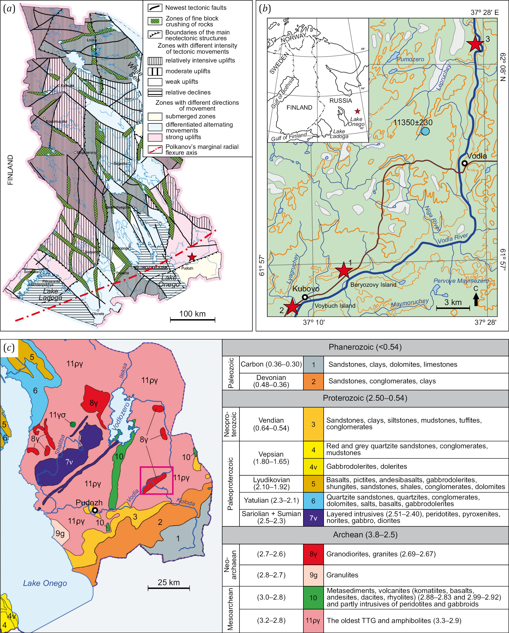
Fig. 1. The location of the studied objects on neotectonic (a), topographic (b) and geological (c) maps [Atlas…, 2021].
The study area is marked by a star on the neotectonic map; local paleoseismodisocations are indicated by numbers 1, 2, 3 on the topographic map; a reservoir is shown with a circle with the radiocarbon date (14C years ago) of the beginning of the process of the organic layer accumulation; on the geological map, the study area is indicated by a pink rectangle.
Paleoseismogeological methods were used to determine pleistoseist zones. The term "paleoseismic deformations" [Nikonov, 1995] was used to designate the combination of seismic effects on the relief, including seismotectonic, seismogravitational and gravitational–seismotectonic dislocations [Solonenko, 1972, 1973], as well as shaking-induced, seismohydrodynamic, seismodynamic, and reverse faulting (thrust) deformations [Nikonov, 1995]. The list of seismic deformations of the Kubovo massif includes seismic ruptures with the linear fracture zones in rocks (seismotectonic type), seismic collapses (seismogravitational type), areal fracture zones (shaking-induced deformations) and earthquake-related colluvial wedges (thrust deformations).
An estimation of the true spatial parameters of paleoseismodisocations was performed using a program for satellite image processing and spatial analysis, which includes a free and open source geographic information system Quantum GIS (QGIS 3.42).
Fig. 2 shows the location, boundaries, and areas of the study objects.
The latest lineaments were described by analyzing remote data (space and aerial photographs, as well as large-scale topographic maps). Geological-structural studies included on-site observation, assessment of bedrock deformations, and analysis of massif fracturing. Nowadays, the estimation of quantitative parameters of faults, as well as age determination for dislocations, are performed during trenching study [McCalpin, 2009]. However, this method cannot be fully utilized to study dislocations at these sites, because their cover is either softly thin or absent.
Another method is sampling lake bottom sediments in the vicinity of paleoseismic dislocations. The disturbed sediments are revealed and dated by radiocarbon analysis. The assessment of general paleogeographic conditions of the study area can be made using micropaleontological methods (pollen and spore and diatom analyses). Unfortunately, there is no suitable body of water near the paleoseismic dislocation. However, we took samples from a small lake (a blue circle in Fig. 1, b) located 16 km northwest of the study area.
The radiocarbon age date (Table 1), obtained from the contact zone of mineragenetic and organic deposits in the lake, is indicative of their accumulation in the first half of the Preboreal.
The deposits were dated in the Laboratory of Geomorphological and Paleogeographic Studies of Polar regions and the World Ocean, SPbU. using standard methods [Arslanov, 1987].
Earthquake intensity (I) was estimated by the paleoseismogeological method for local bedrock disturbances in Fennoscandia [Rodkin et al., 2012] in comparison with the existing paleoseismic dislocation intensity scales [Medvedev et al., 1975; Solonenko, 1977; Michetti et al., 2004; McCalpin, 2009; Nikolaeva, 2019].
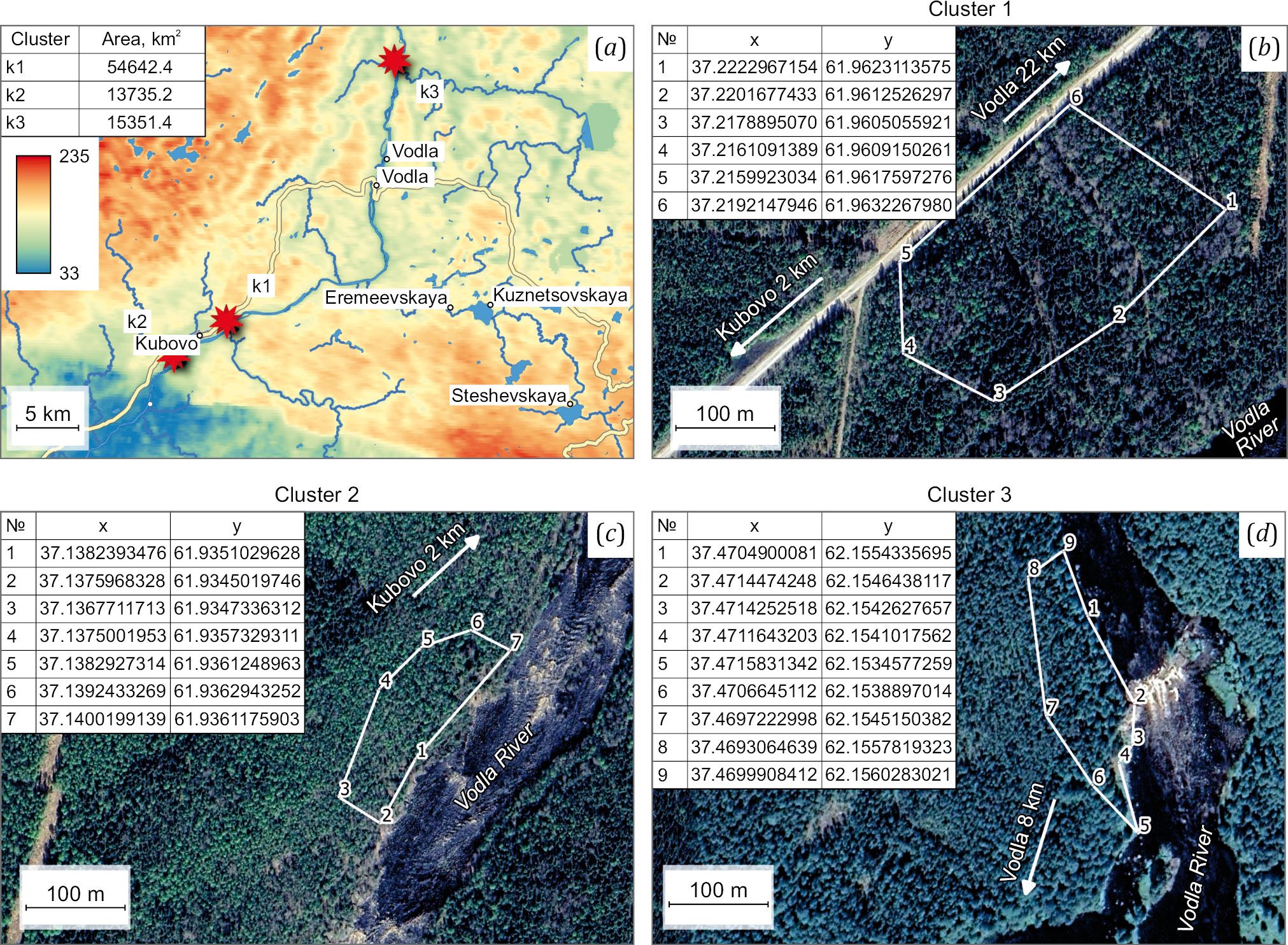
Fig. 2. Location, areas (a), and boundaries of the study objects (b, c, d). Сlusters k1, k2, and k3 are marked by stars No. 1, 2, and 3 in Fig. 1, b.
Table 1. Results of radiocarbon dating (14C) of sediments from the lake in the area of Kubovo village
|
Lab. number |
Depth, cm |
Sample material |
14C age ±1σ |
Mean calendar age ±1σ |
Calibrated age*, cal yr BP |
|
LU-11431 |
525–518 |
сапропель |
9860±130 |
11350±230 |
11820–11060 |
Note. * – the calendar age values are based on the calibration program "OxCal 4.4.4" (calibration curve "IntCal 20", "BOMB 21 NH1"); Christopher Bronk Ramsey (https://c14.arch.ox.ac.uk).
In the context of structural geology, the study area is located in the contact zone of major neotectonic structures: the Fennoscandian Shield and the Russian Plate. It was considered active until the Proterozoic [Lukashov, 1995]. As noted in [Rodkin et al., 2012], the considerably dissected relief of Karelia is predetermined by recent block movements, in particular, the rejuvenation of active faults or of their parts in the Late Glacial and Holocene periods. As it turned out, the territory within which the studied paleoseismodislocation is located also experienced tectonic activation presumably at that time.
A map of fractured rocks of Karelia (Fig. 3) shows that the northwestern (300–340°) and northeastern (20–40–60°) lineament trends are predominant therein [Lukashov, 2004].
The study area is located in the South Karelian structural zone, which has a sublatitudinal strike as a whole [Lukashov, 1987, 1995; Shelekhova, Lavrova, 2019, p. 191]. The structural element of this zone is a deep tectonic depression with signs of neotectonic movements, buried entirely beneath the Quaternary deposits. The bottom of the depression lies 80 m below the sea level. Its Quaternary cover is 150 m thick [Ekman, 1987].
However, the structural relief pattern of the paleoseismodislocation, both in Karelia and in this structural zone, shows mainly two directions: northwest and transverse, northeast. The results of interpretation of aerial and satellite images, as well as of ground survey, show that the predominant strikes of active lineaments – scarps, large hollows, ditches and gorges – are 290°; 330–340–345°; N–S: 0–180° – submeridional; 60–70°. At the same time, the above-mentioned northwest and northeast directions are characteristic of the scarps. Gorges and hollows are more often elongated submeridonally.
The analysis of microfractured massifs in sites 1, 2 (see Fig. 2, b, c) allowed us to identify three main fracture systems with the strike azimuths: 1) 60–70°, 2) 320–340–345°, 3) 290°. These directions are in good agreement with the strikes of neolineaments (Fig. 3), and their associated seismic dislocations confirm their seismic activation in the Holocene.
The strikes of active faults, consistent with the fracture strikes of the scarps and gorges, are also responsible for their seismic activity in the Holocene. The postglacial origin of this disastrous event is indicated by the smoothed primary surface of the crystalline basement showing distinct patterns of seismic activity, e.g. the abundance of dissected, displaced, scattered and shifted blocks and seismogravitational falls.
As already noted, there were found three areas of occurrence paleoseismic events.
The main, most representative paleoseismic dislocation (see Fig. 1, b, Fig. 2, b, claster 1) is located north of the Berezovy Island at an absolute altitude of about 60 m (61°57'42.39" N; 37°13'04" E). The fault scarp (strike azimuth NE 60°; Н=20 m), extending for more than 50 m, is in the contact zone of heterochronous granitoids: the 2680–2670 Ma Kubovo massif and the Archean undissected tonalites, trondhjemites and granodiorites 3000–2750 Ma old (see Fig. 1, c). On the top of the scarp, there are piles of crushed rocks. These are separate blocks (20, 60 and 75 cm) moved from their original location and 5–25 cm wide open fractures, not filled by moraine deposits, which indicates their postglacial origin. Splits shaped like gaping joint-fissures disturbe glacial polishing and striation. The fractures occur in different configurations, sometimes non-linear or tortuous, and have width 5–70 cm or more (in swells) and depth more than 4 m. Separate blocks, detached from the rock mass and displaced from 20 to 50 cm along the subhorizontal to slighly inclined surface, are present throughout the site. The displaced blocks vary in shape and size, but they all display fresh faces and edges. It looks that some of the blocks were detached from the basement rocks (Fig. 4, 5).
The measured directions of the block displacements allowed us to identify the main trends in displacement observed in the northwestern (320–340°) and northeastern (60°) directions. The scarp slope is steep and bears fresh traces of block detachment. The rockfall blocks were formed at the scarp base. Huge rocks, displaced and separated from the main basement, are exposed in the scarp (see Fig. 4; Fig. 5).
Besides, abundant niches, wells and cavities more than 50 cm in width, as well as extension fractures, occur on the steps and on the top of the scarp (see Fig. 4; Fig. 5). Rock fractures and extension faults, showing various trends (NE 70°; NW 320–330–345-350–355; N–S; SE 70°), were measured in different segments of paleoseismic dislocation. The morphology of the fractures, as well as their inconsistency with the main strike of the rocks (NNE 10–60°), the direction of ice movement and the freshness of the scarp walls suggest that the fractures were formed after the glacial retreat. According to the obtained dating (Table 1), this could have occurred in the Holocene no earlier than 11350±230 cal. ya.
The signs of paleoseismic activity on the right bank of the Vodla River were found at an absolute altitude of about 50 m: 61°56'06.08" N; 37°08'17.26" E (marked by a star No. 2 in Fig. 1, b; cluster 2 in Fig. 2, b; Fig. 6).
The ruptures therein are trending SE 110°. The polished crystalline rock exposures with glacial scars were originally reworked by a glacier, which confirms the postglacial origin of the ruptures. The extensional fault, up to 1.5 m in width, forming a niche, is especially noteworthy (Fig. 6, a), The extensional fault edges are sharp and rectangular, with no traces of glacial reworking, which clearly indicates its postglacial formation. The niche is overthrust by a big block, 3×4 m in size (Fig. 6, a).
The block surface is polished subdued (reworked by the glacier), but its basement has sharp straight edges. 20–30 cm wide ruptures in crystalline rocks occur behind the "cave" (61°55'55.79" N; 37°08'04.73" E) (Fig. 6, b, c).
Also noteworthy are the ruptures in the crystalline rocks near the Padun Waterfall (61°56'04.98" N; 37°08'17.22" E; see Fig. 1, в (3), Fig. 2, d (claster 3); Fig. 7, а–d). The apparent length of the ruptures is approximately 100 m; in some places, they are 40 cm wide.
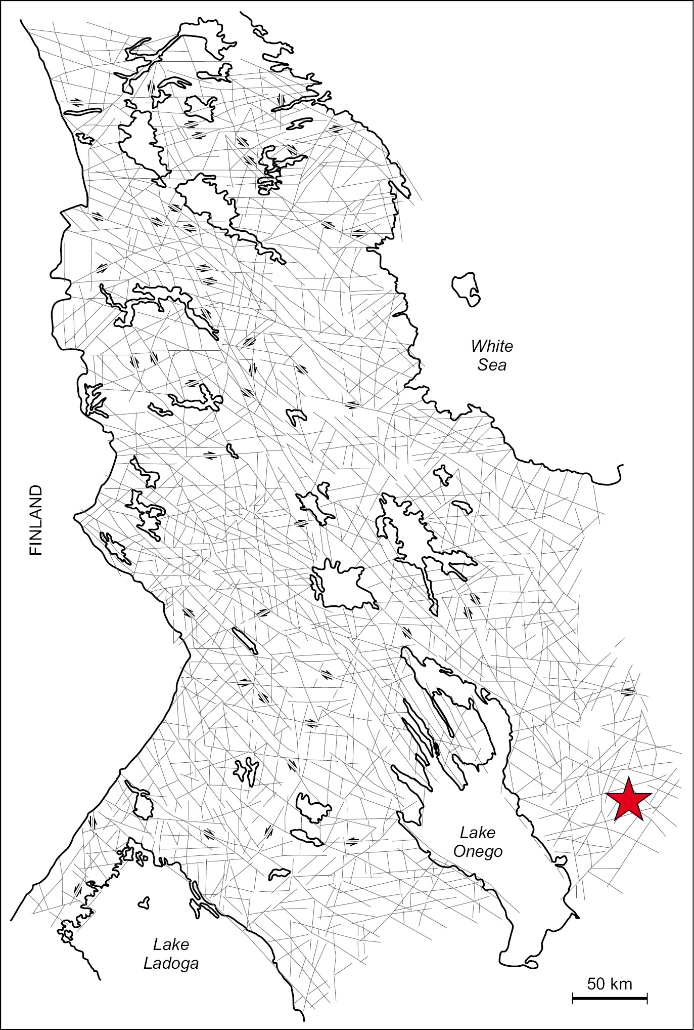
Fig. 3. Map-scheme of systems of fractures (lineaments) of the Karelian crystalline basement (supplemented after [Lukashov, 1976]). The study area is marked by a star.
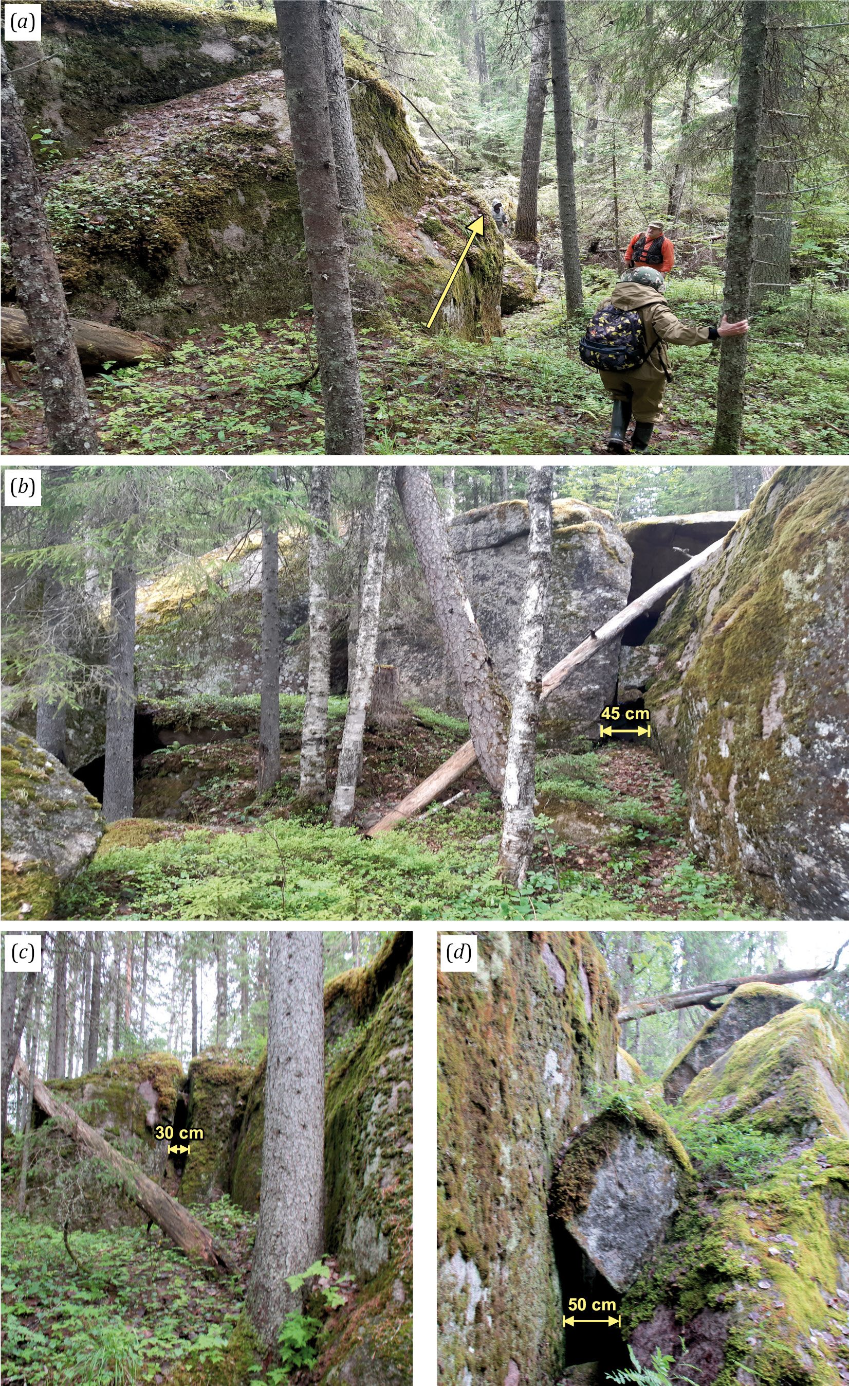
Fig. 4. General view (a) and tectonic faults (b–d) on the paleoseismodislocation.
(a) – paleoseismodislocation (star No. 1 in Fig. 1, b). The arrow shows the main direction of the escarpment; (b) – blocks detached from the rock mass and displaced by 20–50 cm; (c) – huge blocks of rock, detached and removed from the main basement (tensile fractures); (d) – numerous niches, wells and cavities up to a width of 50 cm or more.
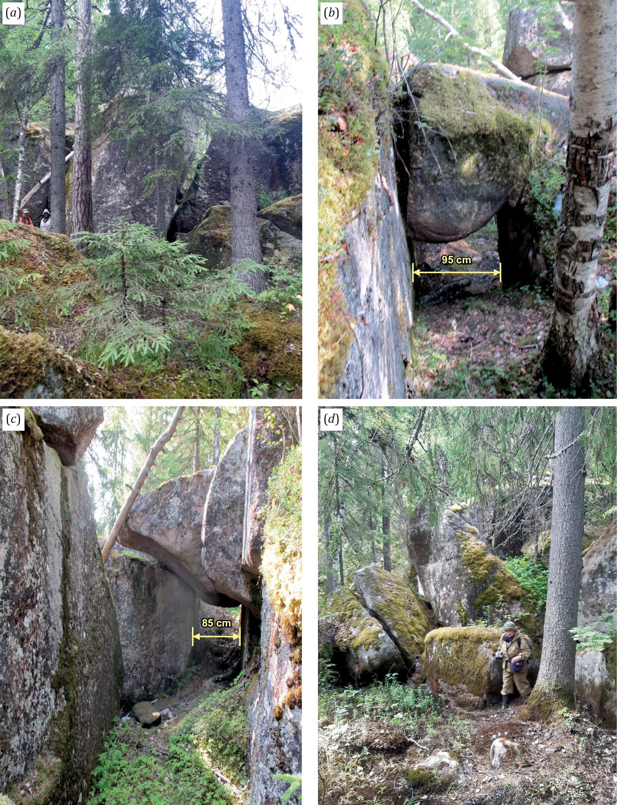
Fig. 5. Different types of tectonic faults on the paleoseismodislocation marked by the star No. 1 in Fig. 1, b. (a) – crushed basement rocks; (b, c) – blocks detached from the basement rocks; (d) – ruptured and displaced blocks.
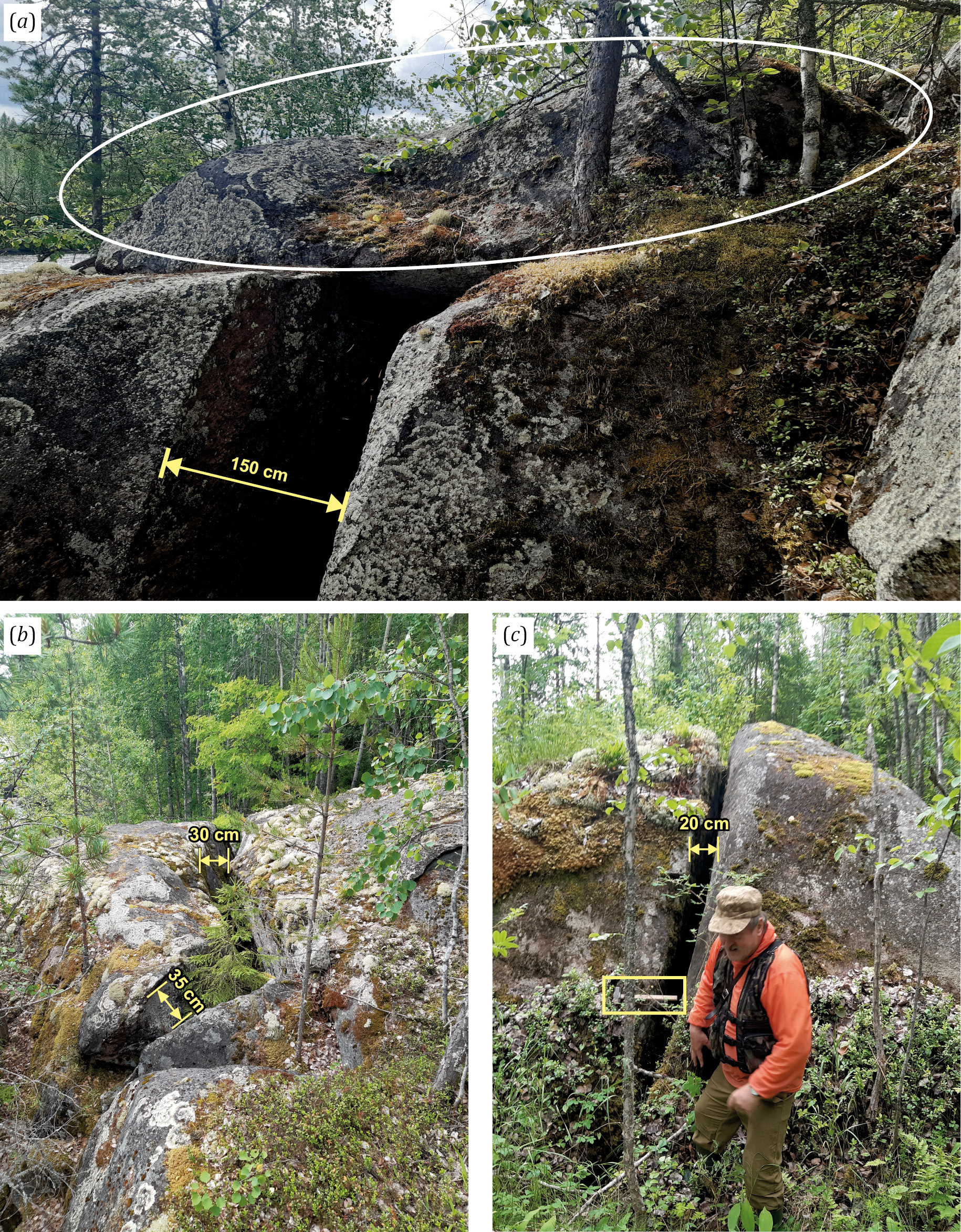
Fig. 6. Tectonic disturbances on the right bank of the Vodla River (paleoseisodislocation marked by the star No. 2 in Fig. 1, b, and k2 in Fig. 2, a, c).
(а) – an extensional fault in the crystalline basement rocks that forms a niche; (б, в) – long faults on the right bank of the river (hammer length 58 cm). The visible length of the faults is 10–15 m.
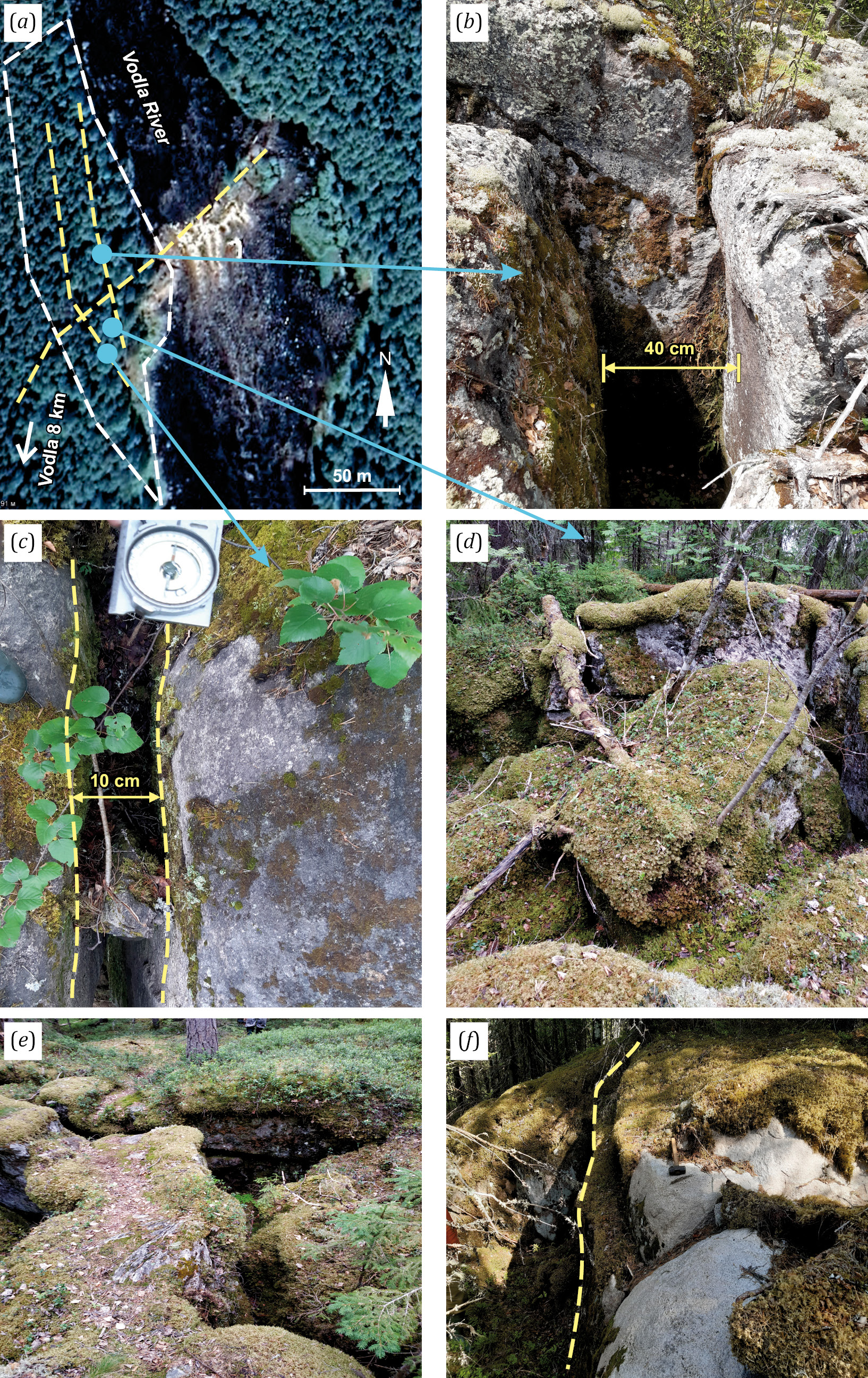
Fig. 7. Tectonic faults near the Padun Waterfall (shown by the asterisk No. 3 in Fig. 1, b, and k3 in Fig. 2, a, d).
(a) – Padun Waterfall in the satellite image. The yellow dotted lines show the faults; the blue lines show the points where photos (b–d) were taken; (b, c) – a fragment of a long fault near the Padun Waterfall; an apparent depth is more than 2 m; (d) – crushed part of the rocks; (e, f) – fractures (faults) on cluster 1.
It is believed that "earthquake dislocations include such phenomena bedrock disturbances with a considerable displacement of its constituent parts, fracturing, rock breaking, block movement along slightly inclined or subhorizontal surfaces, block detachments and block turnings, as well as rockfalls" [Nikolaeva, 2019, p. 446].
Paleoseismic dislocations are indicated by the presence of open fractures. Such fractures have been revealed at all the sites studied. At the same time, the observed displacement of the blocks falls largely within the fracture opening, which does not relate their formation to frost weathering (see Fig. 4, с, Fig. 6, в, с; Fig. 7, в–f).
At paleoseismodislocation 1, the dynamic effect on the basement rocks is indicated by the position of a detached rock block on the fractured top surface at the very edge of the fault (Fig. 8, a); detachment of big blocks from the rock base (Fig. 8, b); phenomena of detaching blocks from the the rock base and their displacement along the slope (see Fig. 5, b, c), formation of the scarp with a height of more than 10 m (Fig. 8, c); detachment and removal of the block from the rock base (Fig. 8, d).
The results of studies of seismodeformations in seismically active zones indicate that the well-pronounced seismodeformations occur during earthquakes with a magnitude (M) of 6.0–6.5 or higher (after [Lukashov, 2004]). According to experts [Nikolaeva, 2019], depending on the fracturing degree of the rock massif, such seismic dislocations could be formed as a result of seismic events of I=VII–IX. According to the classification presented in INQUA Scale, the bedrock fractures tens of meters in length and tens of centimeters to a few meters in width are caused by earthquakes with a shaking intensity of at least IX–X [Michetti et al., 2004].
Fracturing and rockfalls on steep slopes may be caused by seismic shaking with an intensity of at least VI [Medvedev et al., 1975]. Fractures (see Fig. 7, b–f) and rockfalls (see Fig. 5) are clear signs of a sufficiently high intensity of seismic events (≥VIII).
The validity of these estimates requires assessment and further investigation.
We assume that the dislocations discussed herein were caused by a one-time event, which took place after the glacial retreat and the removal of glacial load. This is supported by evidence found for tectonic disturbances: fractures not filled with glacial material, fracturing of the crystalline basement, rockfalls with sharp and fresh edges of the blocks, disruption wall, block displacements etc.
The radiocarbon dating of the organogenic nearby-lake sediments indicates their accumulation in the first half of the Preboreal 11350±230 cal. ya. This suggests that the earthquake could occur no earlier than the retreat of the glacier from this area (13200–14200 cal. ya). During the accumulation of organogenic sediments in the studied lake, the edge of the glacier was already located in western Karelia, where the Salpausselkä ice-marginal formations (ca. 10200 BP) had been deposited [Ekman, Iljin, 1995] at a distance of more than 1500 km from the study area. In spite of the fact that the preliminary study of the lake sediment core sequences showed no visible disturbances in the stratigraphy, further micropaleontological (pollen and spore and diatom analyses) and other studies of marshy areas near local paleoseismodislocations may either support or disprove our assumption. Unfortunately, we have so far not been able to detect any soil filling numerous fractures and use it for dating. Most of the fractures are either unfilled or overgrown with mosses and lichens. Perhaps, a more thorough study will yield traces of fracture filling with loose sediments, and it will be possible to obtain more accurate dates of fracture opening.
А.D. Lukashov [Lukashov, 2004] believed that the earliest paleoseismic dislocations in Karelia occurred 9800–9500 BP. The paleoearthquake and the formation of the "Kubovo" paleoseismic dislocation in Karelia in Karelia could occur earlier than previously assumed.
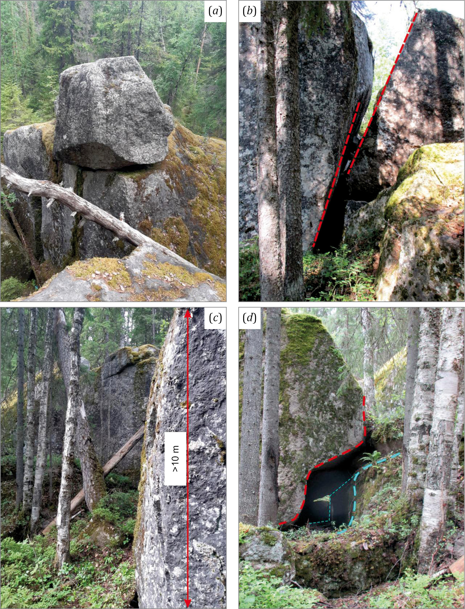
Fig. 8. The photo was taken at the paleoseismodislocation marked by the star No. 1 in Fig. 1, b.
(a) – a block of rock on the fractured top surface at the very edge of the fault, the apparent depth of the fracture is more than 2 m; (b) – a detached block of rock that has slid down the slope; (c) – a scarp with a height of >10 m; (d) – a detached and removed block.
Thus, the study of local topographic disturbances and their distinctive features, as well as the analysis of the geological-structural plan and the lineament network, show the signs of the late glacial and postglacial tectonic and seismic activation in the study area. Young faults at paleoseismic dislocation sites occur in the oldest-known Late Archean crystalline basement rocks (dated at 2680–2670 Ma) of the Fennoscandian Shield-Russian Plate contact zone. Based on the data obtained, it can be concluded that after the glacial retreat and the removal of glacial load in the postglacial time (no earlier than 12000 cal. ya) the study area experienced an earthquake with a seismic intensity of at least VIII on the MSK-64 scale. The age date obtained for the organic deposit in the nearby water body suggests that it could be the earliest Holocene paleoseismic event in Karelia and that the paleoseismic dislocation could be no older than 11350±230 cal. yr.
Further studies in this region are needed to more accurately estimate the intensity and age of paleoearthquakes and to correct a map of paleoseismic processes in Karelia. More detailed studies will reveal other types of tectonic disturbances besides those described in this article. Despite a weak seismic activity in Karelia, there is no doubt that such studies are necessary to obtain reliable data on a possible manifestation of seismic activity in the region.
1. Arslanov Kh.A., 1987. Radiocarbon: Geochemistry and Geochronology. Publishing House of Leningrad State University, Leningrad, 294 p. (in Russian)
2. Atlas of the Republic of Karelia, 2021. Verso, Petrozavodsk, 48 p. (in Russian
3. Avenarius I.G., Vital A.D., Frol V.V., 2005. Recent Tectonic Movements in the Area of the Great Salma Strait (White Sea). In: Theory and Practice of Complex Marine Research in the Interests of Economics and Security Russian North. Abstracts of the International Scientific Practical Conference (March 15–17, 2020, Murmansk). KSC RAS, Apatity, p. 9–10 (in Russian)
4. Baranskaya A.V., Maznev S.V., Romanenko F.A., Shilova O.S., 2019. Recent Crustal Movements of the Karelian Coast of the White Sea. Arctic and Antarctica 2, 16–33 (in Russian) DOI:10.7256/2453-8922.2019.2.29635.
5. Demidov I.N., Lavrova N.B., 2001. The Structure of the Quaternary Cover of the Vodla River Basin (East Karelia) and the Features of Vegetation Development in the Late and Postglacial Period. In: Vodlozersky National Park: Natural Diversity and Cultural Heritage. KarRC RAS, Petrozavodsk, p. 49–60 (in Russian)
6. Ekman I.M., 1987. Quaternary System. In: V.A. Sokolov (Ed.), Geology of Kareia. Nauka, Leningrad, p. 79–93 (in Russian)
7. Ekman I.M., Iljin V.A., 1995. Deglaciation, the Younger Dryas End Moraines and Their Correlation in Russian Karelia and Adjacent Areas. In: J. Ehlers, Ph.L. Gibbard, S. Kozarski, J. Rose (Eds), Glacial Deposits in North-East Europe. CRC Press, London, p. 195–209.
8. Evzerov V.Ya., Kolka V.V., Korsakova O.P., Nikolaeva S.B., 2010. Reconstruction of Pleistocene-Holocene Palaeoecological Settings in the Kola Region. In: Yu.G. Leonov (Ed.), Structure and History of the Development of the Lithosphere. Paulsen, Moscow–Saint Petersburg, p. 491–505 (in Russian)
9. Evzerov V.Ya., Vinogradov A.N., Nikolaeva S.B., 2014. Geodynamics of the White Sea Basin in the Holocene. Bulletin of the Kola Scientific Center of the Russian Academy of Sciences 2, 51–58 (in Russian)
10. Gorbatov E.S., Razumniy S.D., Strelnikov A.A., Rodina S.N., 2020. Identification of the Seismogenic Structure in the Area of the Chupa (North Karelia) and Parameterization of Paleoearthquakes in the Kandalaksha Graben Region. Problems of Engineering Seismology 56 (4), 468–490. https://doi.org/10.3103/S0747923920040040.
11. Gorbatov E.S., Sorokin A.A., 2018. Strong Golocene Paleoearthquakes of the Karelian Coast of the White Sea and the Peculiarities of the Implementation of Their Traces in the Relief. Modern Problems of Mechanics 33 (3), 186–195 (in Russian)
12. Gorbatov E.S., Sorokin A.A., Marakhanov A.V., Larkov A.S., 2017. The Results of Detailed Paleoseismological Studies in the Kindo Peninsula Area (Karelian Coast of the White Sea). Problems of Engineering Seismology 44 (3), 5–24 (in Russian) DOI:10.21455/VIS2017.3-1.
13. Kolodyazhny S.Yu., Terekhov E.N., Baluev A.S., Poleshchuk A.V., Zykov D.S., 2020. Tectonic Features and Stages of Evolution of the Baltic–Mezen Shear Zone in the Phanerozoic, Northwestern Russia. Geotectonics 54, 1–18. https://doi.org/10.1134/S0016852120010057.
14. Kosevich N.I., Romanovskaya M.A., 2014. The Relationship Between the Lineaments and Tectonics of the Kandalaksha Gulf in the White Sea. Moscow University Geology Bulletin 69, 206–212. https://doi.org/10.3103/S0145875214040073.
15. Kostin V.A., 1989. Granitoids and Metasomatites of the Vodlozersky Block (South-Eastern Karelia). Karelian Branch of the USSR Academy of Sciences, Petrozavodsk, 162 p. (in Russian)
16. Kuivamäki A., Vuorela P., Paananen M., 1998. Indications of Postglacial and Recent Bedrock Movements in Finland and Russian Karelia. Report YST-99. Geological Survey of Finland, Espoo, 92 p.
17. Kukkonen I.T., Olesen O., Ask M.V.S., PFDP Working Group, 2010. Postglacial Faults in Fennoscandia: Targets for Scientific Drilling. GFF 132 (1), 71–81. https://doi.org/10.1080/11035891003692934.
18. Lagerbäck R., Sundh M., 2008. Early Holocene Faulting and Paleoseismicity in Northern Sweden. Geological Survey of Sweden Research Paper C 836, 84 p.
19. Lukashov А.D., 1976. Neotectonics of Karelia. Nauka, Leningrad, 109 p. (in Russian)
20. Lukashov А.D., 1987. Neotectonic Movements. In: V.A. Sokolov (Ed.), Geology of Kareia. Nauka, Leningrad, p. 125–129 (in Russian)
21. Lukashov А.D., 1993. Paleoseismic Dislocations in Zaonezhye. In: A.P. Zhuravlev, V.P. Orfinsky (Eds), Kizhsky Vestnik. Iss. 2. Petrozavodsk, p. 35–42 (in Russian)
22. Lukashov А.D., 1994. An Experience in Using Sound Geolocation in the Study of Paleoseismic Dislocations in Zaonezhye. In: A.I. Golubev (Ed.), Geology and Magmatism of Karelia. Operational Information Material. KarRC RAS, Petrozavodsk, p. 45–48 (in Russian)
23. Lukashov A.D., 1995. Paleoseismotectonics in the Northern Part of Lake Onega (Zaonezhskij Peninsula, Russian Karelia). Geological Survey of Finland, Espoo, 36 р.
24. Lukashov А.D., 2002. Paleoseismic dislocations in Karelia. In: Deep Structure and Geodynamics of Fennoscandia and Marginal and Transition Zones. Proceedings of the VIII International Conference (September 16‒20, 2002). KarRC RAS, Petrozavodsk, p. 154–156 (in Russian)
25. Lukashov A.D., 2004. Geodynamics of Recent Times. In: N.V. Sharov (Ed.), Deep Structure and Seismicity of the Karelian Region and Its Margins. KarRC RAS, Petrozavodsk, p. 150–178 (in Russian)
26. Lukashov А.D., Belashev B.Z., 2002. On Model Evaluation of Paleoearthquake Magnitudes. In: Deep Structure and Geodynamics of Fennoscandia and Marginal and Transition Zones. Proceedings of the VIII International Conference (September 16‒20, 2002). KarRC RAS, Petrozavodsk, p. 153–156 (in Russian)
27. Marakhanov A.V., Romanenko F.A., 2014. New Data on Postglacial Seismic Dislocations of the Northern Karelia (Karelian Coast of the White Sea). In: Geodynamics and Ecology of the Barents Region in the XXI Century. Yudakhin Readings. Proceedings of the All-Russian Conference with International Participation (September 15–18, 2014). Institute of Environmental Problems of the North of the UB RAS, Arkhangelsk, p. 137–140 (in Russian)
28. McCalpin J.P. (Ed.), 2009. Paleoseismology. 2nd Edition. Academic Press, USA, 647 p.
29. Medvedev S.V., Ershov I.A., Popova E.V., 1975. A Project of a Scale for Determination of Earthquake Intensity. In: Seismic Scale and Methods for Measurement of Seismic Intensity. Nauka, Moscow, p. 11–39 (in Russian)
30. Michetti A.M., Esposito E., Gürpinar A., Mohammadioun B., Mohammadioun J., Porfido S., Rogozhin E., Serva L. et al., 2004. The INQUA Scale. An Innovative Approach for Assessing Earthquake Intensities Based on Seismically-Induced Ground Effects in Natural Environment. Memorie Descriptive Della Carta Geologica d’Italia, Vol. 67. SystemCart Srl, Roma, 116 p.
31. Morey A.E., Goldfinger C., Briles C.E., Gavin D.G., Colombaroli D., Kusler J.E., 2013. Are Great Cascadia Earthquakes Recorded in the Sedimentary Records from Small Forearc Lakes? Natural Hazards Earth System Science 13 (10), 2441–2463. https://doi.org/10.5194/nhess-13-2441-2013.
32. Mörner N.-A., 1981. Crustal Movements and Geodynamics in Fennoscandia. Tectonophysics 71, 241–251. https://doi.org/10.1016/B978-0-444-41953-8.50034-7.
33. Mörner N.-A., 1985. Paleoseismicity and Geodynamics in Sweden. Tectonophysics 117 (1–2), 139–153. https://doi.org/10.1016/0040-1951(85)90242-2.
34. Mörner N.-A., 2003. Paleoseismicity of Sweden. A Novel Paradigm. JOFO Grafiska AB, Helsingborg, 320 p.
35. Mörner N.-A., 2004. Active Faults and Paleoseismicity in Fennoscandia, Especially Sweden. Primary Structures and Secondary Effects. Tectonophysics 380 (3–4), 139–157. https://doi.org/10.1016/j.tecto.2003.09.018.
36. Mörner N.-A., 2009. Late Holocene Earthquake Geology in Sweden. Geological Society of London Special Publications 316, 179–188. https://doi.org/10.1144/SP316.11.
37. Mörner N.-A., 2011. Paleoseismology: The Application of Multiple Parameters in Four Case Studies in Sweden. Quaternary International 242 (1), 65–75. https://doi.org/10.1016/j.quaint.2011.03.054.
38. Mörner N.-A., 2013a. Drainage Varves, Seismites and Tsunamites in the Swedish Varve Chronology. GFF 135 (3–4), 308–315. https://doi.org/10.1080/11035897.2013.764546.
39. Mörner N.-A., 2013b. Patterns in Seismology and Palaeoseismology, and Their Application in Long-Term Hazard Assessments: The Swedish Case in View of Nuclear Waste Management. Pattern Recognition in Physics 1, 75–89. DOI:10.5194/prp-1-75-2013.
40. Mörner N.-A., 2017. Liquefaction Structures from a High-Magnitude Paleoseismic Event at About 12,400 C14-Years BP in Southern Sweden. Open Journal of Earthquake Research 6 (4), 216–227. https://doi.org/10.4236/ojer.2017.64014.
41. Mörner N.-A., Sjoberg R., 2018. Merging the Concepts of Pseudokarst and Paleoseismicity in Sweden: A Unified Theory on the Formation of Fractures, Fracture Caves, and Angular Block Heaps. International Journal of Speleology 47 (3), 393–405. https://doi.org/10.5038/1827-806X.47.3.2225.
42. Mörner N.-A., Sun G., 2013. Paleoearthquake Deformations Recorded by Magnetic Variables. Earth and Planetary Sciences Letters 267 (3–4), 495–502. https://doi.org/10.1016/j.epsl.2007.12.002.
43. Nikolaeva S.B., 2019. Postglacial Tectonics and Palaeoseimic Dislocation in the Kovda Area (Kandalaksha Bay, Eastern Fennoscandian Shield). Vestnik of Saint Petersburg University. Earth Sciences 64 (3), 434–453 (in Russian) https://doi.org/10.21638/spbu07.2019.304.
44. Nikolaeva S.B., 2022. Traces of Seismic Activity in the Lake Bottom Sediments of Eastern Fennoscandia. Geodynamics & Tectonophysics 13 (5), 0676 (in Russian) https://doi.org/10.5800/GT-2022-13-5-0676.
45. Nikolaeva S.B., Lavrova N.B., Denisov D.B., Tolstobrov D.S., 2016a. Evidence of Catastrophic Processes in Lake-Bottom Sediments of the Babinskaya Imandra Western Coast (Kola Region). Proceedings of the Russian Geographical Society 148 (4), 38–52 (in Russian)
46. Nikolaeva S.B., Nikonov A.A., Shvarev S.V., Rodkin M.V., 2016b. Comprehensive Paleoseismic Geological Studies in a Key Site in Southwestern Kola Peninsula (Northeast of the Fennoscandian Shield). Doklady Earth Sciences 469, 656–660. https://doi.org/10.1134/S1028334X16070138.
47. Nikolaeva S.B., Nikonov A.A., Shvarev S.V., Rodkin M.V., 2018. Detailed Paleoseismogeological Studies in the Side Zone of the Imandra Lake Depression (Kola Region): New Approaches and Results. Russian Geology and Geophysics 59 (6), 697–708 https://doi.org/10.1016/j.rgg.2018.05.008.
48. Nikolaeva S.B., Rodkin M.V., Shvarev S.V., 2021. Late Glacial and Postglacial Seismicity in the Northeastern Fennoscandian Shield: Tectonic Position and Age of Paleoearthquakes near Murmansk. Bulletin of the Geological Society of Finland 93, 53–72. https://doi.org/10.17741/bgsf/93.1.004.
49. Nikolaeva S.B., Tolstobrov D.S., Ryazantsev P.A., 2023. Evidence for Postglacial Seismicity in Lacustrine Records in the Western Kola Peninsula (North-Western Russia). The Holocene 33 (12) 1441–1452. https://doi.org/10.1177/09596836231197738.
50. Nikolaeva S.B., Tolstobrov D.S., Tolstobrova A.N., 2019. Disturbances in the Primary Stratigraphy of Lake Sediments on the Murmansk Coast (Russia): Their Identification and Relationship with Catastrophic Events. Baltica 32 (2), 156–169. https://doi.org/10.5200/baltica.2019.2.3.
51. Nikonov A.A., 1995. Terminology and Classification of Seismogenic Disturbances in Topography. Geomorphology and Paleogeography 1, 4–10 (in Russian)
52. Nikonov A.A., 2007. Ancient Tsunami at Solovki Islands. Priroda 9 (1105), 33–40 (in Russian)
53. Nikonov A.A., 2015. An Unprecedented Disaster in the Village Kashkarantsy. Priroda 1 (1193), 51–55 (in Russian)
54. Nikonov A.A., Poleshchuk A.V., Zykov D.S., 2017. On Recent Faults and Paleoseismic Fractures in the Palaeoproterozoic Onega Structure of the Fennoscandian Shield. Transactions of KarRC RAS 11, 3–18 (in Russian) https://doi.org/10.17076/geo549.
55. Nikonov A.A., Shvarev S.V., 2013. Holocene Tectonic Activity and Seismicity of the White Sea Basin: Abstracts of the Report at the Institute of the Physics of the Earth RAS Paleoseismological Seminar Session (in Russian) Available from: https://ifz.ru/nauka/fundamentalnyie/goloczenovaya-tektonicheskaya-aktivnost-i-sejsmichnost-belomorskogo-bassejna (Last Accessed January 16, 2025).
56. Nikonov A.A., Shvarev S.V., 2015. Seismolineaments and Destructive Earthquakes in the Russian Part of the Baltic Shield: New Solutions for the Past 13 Thousand Years. In: Geological and Geophysical Environment and Diverse Manifestations of Seismic Activity. Proceedings of the International Conference (September 23–25, 2015). Technical Institute NEFU, Neryungri, p. 243–251 (in Russian)
57. Olesen O., Blikra L.H., Braathen A., Dehls J.F., Olsen L., Rise L., Roberts D., Riis F., Faleide J.I., Anda E., 2004. Neotectonic Deformation in Norway and Its Implications: A Review. Norwegian Journal of Geology 84 (1), 3–34.
58. Poleshchuk A., Shvarev S. 2018. Some Features of Deformation Structures in an Esker on the Southern Margin of the Fennoscandian Shield. Bulletin of the Geological Society of Finland 90, 291–300. https://doi.org/10.17741/bgsf/90.2.011.
59. Rodkin M.V., Nikonov А.A., Shvarev S.V., 2012. Seismic Impact Estimation from Data on Deformations and Displacements in Rock Massifs. Geodynamics & Tectonophysics 3 (3), 203–237 (in Russian) https://doi.org/10.5800/GT-2012-3-3-0072.
60. Shelekhova T.S., Lavrova N.B., 2019. Paleoenvironmental Reconstructions and a Sedimentological Evidence of Paleoseismic Activity ca 9000 Yr BP in Karelia, NW Russia, Based on Lake Sediment Studies on Mount Vottovaara. Baltica 32 (2) 190–201. https://doi.org/10.5200/baltica.2019.2.6.
61. Shelekhova T.S., Lavrova N.B., Lobanova N.V., Tolstobrov D.S., Vashkov A.A., Lazareva O.V., Rodionov G.N., 2023. Paleogeographical Reconstructions of the Holocene Environment on the Karelian Shore of the White Sea (Keret Area, Russia). The Holocene 34 (3), 306–324. https://doi.org/10.1177/09596836231211871.
62. Shelekhova Т.S., Lobanova N.V., Lavrova N.B., Rodionov G.N., 2022. Paleogeographic Conditions of Human Habitation on the Karelian Coast of the White Sea in the Late-Holocene (Chupa Town, Karelia, Russia). The Holocene 32 (11), 1222–1232. https://doi.org/10.1177/09596836211041733.
63. Shvarev S.V., Bondar I.V., Romanenko F.A., Lugovoy N.N., 2022. Traces of the Holocene Paleoearthquekes on the Islands of the Kuzokotsky Archipelago https://doi.org/10.21455/GPB2022.2-2.
64. Shvarev S.V., Nikonov A.A., Rodkin M.V., Poleshchuk A.V., 2018. The Active Tectonics of the Vuoksi Fault Zone in the Karelian Isthmus: Parameters of Paleo-Earthquakes Estimated from Bedrock and Soft-Sediment Deformation Features. Bulletin of the Geological Society of Finland 90 (2), 257–273, https://doi.org/10.17741/bgsf/90.2.009.
65. Shvarev S.V., Rodkin M.V., 2018. Structural Position and Parameters of the Paleoearthquakes in the Area of Vottovaara Mountain (Middle Karelia, Eastern Part of the Fennoscandian Shield). Seismic Instruments 54, 199–218. https://doi.org/10.3103/S0747923918020093.
66. Shvarev S.V., Rodkin М.V., 2017. Structural Position and Settings of Paleoearthquakes in Area of the Mount Vottovaara (Middle Karelia, Eastern part of the Fennoscandian Sheet. Problems of Engineering Seismology 44 (2), 35–60 (in Russian) DOI:10.21455/VIS2017.2-3.
67. Solonenko V.P., 1972. Seismogenic Ruptures of Hillsides. In: Hydrogeology and Engineering Geology. Reports of Soviet Geologists at the XXIV Session of the International Geological Congress. Nauka, Moscow, p. 142–151 (in Russian)
68. Solonenko V.P., 1973. Earthquakes and Relief. Geomorphology 4, 3–13 (in Russian)
69. Solonenko V.P., 1977. Seismogenic Deformations and Paleoseismological Method. In: V.P. Solonenko (Ed.), Seismic Zonation of Eastern Siberia and Its Geological and Geophysical Basis. Nauka, Novosibirsk, p. 5–47 (in Russian)
70. Strelkov S.A., 1973. Morphostructures of the Northeastern Baltic Shield and Trends in Their Formation. In: S.A. Strelkov, B.I. Koshechkin (Eds), Paleogeography and Morphostructure of the Kola Peninsula. Nauka, Leningrad, p. 5–80 (in Russian)
71. Subetto D.A. (Ed.), 2022. Paleolimnology of Lake Onego: From the Onego Ice Lake to the Present State. Publishing House of the KarRC RAS, Petrozavodsk, 331 p. (in Russian) DOI:10.17076/m-onegopaleo23.
72. Sviridenko L.P., 2008. Polkanov Flexure and Its Role in Geodynamics of the East European Platform. In: Relationship Between the Surface and Deep Structures of the Earth’s Crust. Proceeding of the 14th International Conference (October 27–31, 2008). Part 2. KSC RAS, Petrozavodsk, p. 171–173 (in Russian)
73. Verzilin N.N., Bobkov A.A., 2009. In the Footsteps of Postglacial Seismic Events in the Northeastern Boundary of the White Sea’s Chupa Bay. In: E.M. Nesterov (Ed.), Excursions in Geology. Vol. V. Publishing House of the Herzen State Pedagogical University of Russia, Saint Petersburg, p. 40–49 (in Russian)
74. Zaretskaya N.E., Ludikova A.V., Shvarev S.V., Kuznetsov D.D., Kutenkov S.A., 2022. Paleoseismic Fault Trenches as Unique Archives of the White Sea Holocene History. Doklady Earth Sciences 507, S61–S68. https://doi.org/10.1134/S1028334X22601249.
75. Zhuravlev A.P., Lukashov A.D., Ekman I.M., Ilyin V.A., 1988. On Post-glacial Earthquakes in Karelia According to Archaeological and Geological-Geomorphological Data. In: Geology and Petrology. Operational Information Materials for 1987. Karelian Branch of the USSR Academy of Sciences, Petrozavodsk, p. 58–62 (in Russian)
76. Zykov D.S., 1997. On Active Structures and Possible Paleoseismodislocations in Karelia. Geomorphology 3, 58–62 (in Russian)
77. Zykov D.S., Poleshchuk A.V., 2016. The Results of the Interaction of Some Geodynamic Systems on the East European Platform in Recent Times. In: Actual Problems of Dynamic Geology in the Study of Platform Areas. Proceedings of the All-Russian Scientific Conference (May 24–26, 2016). Pero, Moscow, p. 24–26 (in Russian)
11 Pushkinskaya St, Petrozavodsk 185910
11 Pushkinskaya St, Petrozavodsk 185910
11 Pushkinskaya St, Petrozavodsk 185910
Shelekhova T.S., Lavrov O.B., Rodionov G.N. NEW DATA ON POSTGLACIAL SEISMIC DISLOCATIONS IN THE FENNOSCANDIAN SHIELD-RUSIAN PLATE CONTACT ZONE, PUDOZH DISTRICT, KARELIA, RUSSIA. Geodynamics & Tectonophysics. 2025;16(4):0840. https://doi.org/10.5800/GT-2025-16-4-0840. EDN: IDBADB


Editor-in-Chief
Sklyarov E.V.664033, Irkutsk, Lermontova St., 128,
IEC SB RAS Institute of the Earth's crust
E-mail.: gt@crust.irk.ru
tel.: 8 3952 425422
Processing of personal data


