


Contents
Scroll to:
https://doi.org/10.5800/GT-2025-16-3-0825
EDN: wmqwmi
Scroll to:
The synthesis and analysis of new geological and geophysical data through the Black Sea-BalkanAnatolian-Caspian megaregion been appeared during the last two decades have been carried out. All collected materials make it possible to give a completely different interpretation of long-known facts and to provide a new-level consideration of the onset time and mechanism of the Greater Caucasus uplift, as well as genetic type and filling mechanism of the Ciscaucasia troughs. It has shown that the Greater Caucasus orogen became a high and an intensively eroded mountain structure not earlier than the Pliocene. Its formation was not due to the Oligocene (or earlier) initiation of long-term tectonic near-meridional crustal shortening and slow gradual uplift, but occurred as a rapid uplift of the crustal block in the Pliocene – Quaternary in response to the delamination of a fragment of the lithosphere beneath the central part of the Caucasus region. The modern geomorphological appearance of the Greater Caucasus orogen was greatly contributed to by the deformations originated from large-amplitude right-lateral strike-slip movements with additional transpression along the regional Crimea-Caucasus-Kopetdagh fault zone, as well as from the gravitational collapse of the orogen. Most of the Cenozoic sediments, filling the Ciscaucasia troughs, have accumulated in the basin located in the northeastern part of the Eastern Paratethys. Until the Pliocene this basin was a pericratonic sedimentary basin on the southern shelf of Northern Eurasia, which experienced the accumulation of sediment transported primarily from the ancient East European and young epi-Hercynian Scythian platforms. The sedimentary basin, with relics as the Ciscaucasia troughs in the present-day structure of Ciscaucasia, was separated from the Eastern Paratethys by the rapidly uplifting Greater Caucasus orogen at the very end of the Pliocene – Quaternary and transformed into a piedmont trough wherein the sediment from the GC started to accumulate.
Kuznetsov N.B., Romanyuk T.V. ON THE ONSET TIME AND MECHANISM OF THE GREATER CAUCASUS UPLIFT AS WELL AS GENETIC TYPE AND FILLING HISTORY OF THE CISCAUCASIA TROUGHS – TRADITIONAL AND MODERN INTERPRETATIONS. Geodynamics & Tectonophysics. 2025;16(3):0825. https://doi.org/10.5800/GT-2025-16-3-0825. EDN: wmqwmi
Among the sedimentary basins located in the peripheral parts of the continental massifs, structurally atributed to by the platforms, there could be distinguished piedmont troughs (also termed as foredeeps or forelands) and pericratonic troughs. It was already mentioned in [Arkhangelsky, Shatsky, 1933, p. 141] that the piedmont troughs "are the areas of accumulation of new thick sediments transported from the adjacent uplifted parts of the folded system". On this basis, the Ciscaucasia trough system was interpreted as a system of piedmont troughs [Arkhangelsky, 1927], paragenetically connected with the Greater Caucasus (GC) and predominantly filled by the erosion products from the GC constituting complexes. Thus the interpretation of the Ciscaucasia troughs-fill history and their genetic belonging (tectonic nature) generally go back to the first quarter of the XX century, i.e. started to form almost 100 years ago.
The opinion that the Ciscaucasia troughs are piedmont basins (and, likewise, foredeeps or forelands) still dominates among the scientists exploring different branches of the Earth science, including tectonists and petroleum geologists. This opinion forms the basis of tectonic [Milanovsky, Khain, 1963; Sharafudinov, 2003; Nikishin et al., 2010; Popkov, 2010] and paleogeographic [Popov et al., 2009; Beluzhenko, 2011; Popov, Patina, 2023] concepts, as well as of strategies for hydrocarbon exploration survey and numerical modeling of the evolution of generation-accumulation hydrocarbon systems of the North Caucasus region and Ciscaucasia [Afanasenkov et al., 2007; Kerimov et al., 2021].
In their landmark study, [Milanovsky, Khain, 1963, p. 287] found that from as early as the Oligocene "the Caucasus enters its final stage ˂…˃ of development – the stage of formation of large folded-block uplifts (meganticlinoriums) and their associated piedmont and intermountain troughs". The next paragraph states the following: "During the Oligocene, the Greater Caucasus becomes an orographic uplift, growing in height and breadth and starting to transport sandy-clay material to its bordering depressions" [Milanovsky, Khain, 1963, p. 287]. In [Popkov, 2010, p. 25] it is written: "The West Kuban piedmont trough, north of the folded orogenic structures of the West Caucasus, was initiating in the Oligocene on the subsiding southern part of the Scythian Plate". Similar ideas have been proposed by A.M. Nikishin and his followers.
V.V. Belousov considered the initial formation age of the GC somewhat younger. He believed that "at the boundary between the Maikop and Chokrak deposits1 ˂…˃ at the place of the former Caucasus basin there occurs an area of intensive upward surface motions which exactly began to initiate the Caucasus Mountain Range in the modern sense of the word" [Belousov, 1940, p. 67].
A still earlier beginning of the orogeny in its current form and related beginning of the Ciscaucasia trough formation are reported in [Timoshkina et al., 2010] and in [Klavdieva, 2007] – a candidate’s dissertation prepared under the guidance of N.V. Koronovsky. In the former publication, using mathematical modeling of the Ciscaucasia evolution, the authors concluded that the GC newest and present day orogen has three stages. These three stages were related with the Tarkhanian, Konka-Early Sarmatian and Pontian regional compression which occurred 16.6–15.8, 14.3–12.3 and 7.0–5.2 Ma ago, respectively [Timoshkina et al., 2010]. In [Klavdieva, 2007], using a similar approach, it was shown that the beginning of a rapid uplift of the GC falls within the Late Sarmatian (about 10 Ma).
In recent years, some of the scientists have once again focused on the Ciscaucasia trough-fill mechanism and history [Kuznetsov et al., 2023, 2024а, 2024b; Kolodyazhny et al., 2024а, 2024b, 2024c; Postnikova et al., 2024; Dantsova et al., 2024; Patina et al., 2024а, 2024b]. That is, a question of tectonic nature of the Ciscaucasia troughs, which seemed to been solved one hundred year ago by founders of the Russian geological science, is back on the agenda.
The onset time of the GC uplift, or the orogen-scale uplift history in the Crimea-Caucasus area in a larger context, including also the Crimean Mountains and Lesser Caucasus, has been under geological discussion since the late XIX – early XX centuries when the geosynclinal concepts had dominated. According to those concepts, the Caucasus region was experienced multiple alternations of subsidence and uplift processes during the Late Precambrian and Phanerozoic orogeny. The most recent uplift of the Caucasus and formation of its appearance, similar to that of the present-day, was presumably firstly shown by N.I. Andrusov on the paleogeographic maps he drew for the Early Miocene [Andrusov, 1896]. Well-known still are A.D. Arkhangelsky’s [Arkhangelsky, 1923; and others] ideas that the GC orogen and formation of its adjacent Ciscaucasia piedmont trough, filled with the mountain erosion products, started as early as in the Oligocene. These ideas found their reflection in classical works [Arkhangelsky, Shatsky, 1933; Arkhangelsky et al., 1937; Arkhangelsky, 1941; Milanovsky, Khain, 1963; Muratov, 1967; Milanovsky, 1968; and many others].
However, even prior to the Great Patriotic War, Corr. Memb. AS ArSSR L.A. Vardanyants (a researcher of the Seismological Institute AS USSR, and then of the VSEGEI) wrote that the mountainous relief of the GC formed only in the most recent geological past. In particular, in his monograph [Vardanyants, 1948, p. 31], referring to his pre-war studies and publications [Vardanyants, 1933а, 1933b], L.A. Vardanyants wrote: "Uplifting of the Caucasus and its relief dissection, i.e. formation of the present-day appearance of these high mountains, began as early as the Apsheronian but was most rapid only in the post-Pliocene and generally stopped by the beginning of the Khvalynian"2. But L.A. Vardanyants’ ideas were not supported by the geological community of that time, so that there is still wide acceptance of Academician A.D. Arkhangelsky’s earlier belief system [Arkhangelsky, 1923, 1927, 1941; and others] relating the beginning of the present-day GC orogenic uplift to the Paleogene or even earlier period. This belief system is most fully described in [Milanovsky, Khain, 1963]. Those ideas have been transformed from the fixist tectonic terminology of that time into modern mobilist terms. Withal the essential understanding of the geological problems of the Caucasus region has undergone only insignificant (cosmetic) changes and is found dominantly in the geological literature of Russia and in the most part of those published abroad.
According to these views, the GC is considered as a compressional structure resulted from the Arabia-Eurasia collision [Vincent et al., 2007; Mumladze et al., 2015; Ismail-Zadeh et al., 2020; Mossar et al., 2022; Vasey et al., 2020, 2023; and references therein]. These publications state that the GC is the Alpine collisional orogen, which emerged as an individual structure at the site of the former Jurassic-Paleogene deep-water rift trough. The major mechanism for the GC orogenic uplift is thought to be related to tectonic shortening of the crust across the GC under a regional near-meridional compression regime which caused the deformations and crustal thickening [Ershov et al., 1999; Afanasenkov et al., 2007; Timoshkina et al., 2010; Nikishin et al., 2010; Vasey et al., 2020, 2023; and references therein]. The western segment of the GC in Fig. 1 exemplifies a conceptual scheme of the GC formation, the views on its key formation time limits and formation mechanism.
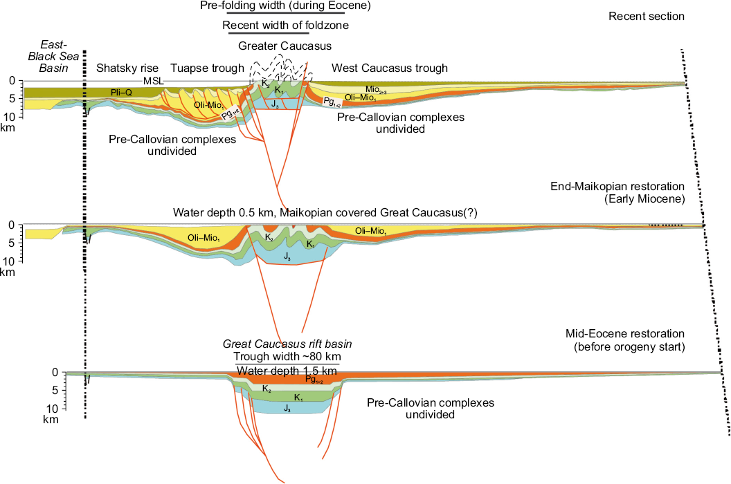
Fig. 1. Reconstruction of the geological history of the western part of the Greater Caucasus and adjacent troughs (after [Nikishin et al., 2010]).
Pli–Q – Pliocene – Quaternary, Mio2+3 – Middle – Upper Miocene, Oli–Mio1 – Oligocene – Early Miocene (Maikop), Pg1+2 – Paleocene – Eocene, K2 – Late Cretaceous, K1 – Early Cretaceous, J3 – Callovian and Late Jurassic. Bold red lines show the faults, gray lines stand for Cretaceous – Eocene eroded strata.
However, even with a large volume of geological, geomorphological, seismic and other data now available [Leonov, 2007; Kopp, Kurdin, 1980; Kopp, 1997; Dotduev, 1986; Rastsvetaev, 1989; Bazhenov, Burtman, 1987; Leonov et al., 2001; State Geological Map…., 2000, 2002; Popkov, 2006; Panov, Lomize, 2007; Kamzolkin et al., 2018; Somin et al., 2013; Rogozhin et al., 2015; Pavlenkova et al., 2022; Cowgill et al., 2016; Gamkrelidze et al., 2020; Vasey et al., 2020, 2023; Vincent et al., 2005, 2007, 2011, 2013, 2014, 2020; and references therein], there is still no consensus regarding the understanding of nuances of the complex internal structure of the GC mountains, just as there is no acknowledged meaningful interpretation of structural differences and formation history of their different parts (see Sections 3 and 6 below).
The question of the onset time uplift and formation mechanism of the GC is directly related to understanding the genetic nature of the Ciscaucasia troughs and troughs-fill mechanisms. In the middle 1920s, A.D. Arkhangelsky identified for the first time the Cenozoic trough, occupying the western part of the northern Ciscaucasia, a larger part of the Sea of Azov and Steppe Crimea, and named this trough – CisBlackSea trough [Arkhangelsky, 1923]. After a third of a century, M.V. Muratov named it the Indol-Kuban trough – after the names of the Indol River in the Crimea and the Kuban River in the GC and in the west of the Ciscaucasia [Muratov, 1955], – which has become more popular nowadays. This trough and/or some of its parts are also mentioned in literature as Azov-Kuban, Kuban, West and East Kuban, West Caucasian and under other names. Both A.D. Arkhangelsky and M.V. Muratov considered the Indol-Kuban trough and some of its structural elements – the Kuban trough in particular – as a piedmont trough, filled predominantly with the sediments eroded from the Crimea-Caucasus orogen. Until recently, these traditional views were dominant. Thus, according to the paleogeographic reconstructions [Popov, Patina, 2023] the Early Oligocene and Early Miocene low-mountain insular area (an island chain) – a source of fine-grained clastic material – was situated where the GC orogen now resides (Fig. 2, а, b). The Oligocene – Lower Miocene Maikop Formation in the Indol-Kuban trough is interpreted as a lower (thin) molasse, which consists of the sediments eroded from the western segment of the GC orogen at its initial uplift stages [Milanovsky, Khain, 1963; Muratov, 1967; Milanovsky, 1968; Kholodov, Nedumov, 1981; and others]. One of the grounds for the reconstruction of the uplift, already existed in the Oligocene on the future site of the GC orogen (its western segment in particular), is the lack of the strata younger than the Oligocene therein. Nevertheless, there probably were such strata on the future site of the western segment of the GC; they could just fall within the erosion-prone area and be completely eroded during the later orogenic uplift.
There is a widespread perception that the GC has been a vast and intensely eroded land area since the Middle Miocene [Andrusov, 1896; Zhizhchenko, 1940; Milanovsky, Khain, 1963; Milanovsky, 1968]. This perception was also reflected in the latest publications [Popov, Patina, 2023] (Fig. 2, c, d). The post-Oligocene strata in the Indol-Kuban trough and on the northern slope of the western segment of the GC are considered as a molasse – a mark of at least some of high-land areas in the western segment of the GC orogen contributing most of the erosion material to these strata [Milanovsky, Khain, 1963; Muratov, 1967; Milanovsky, 1968]. The well-known Late Oligocene and post-Oligocene randomly structured (olistosrome) coarse-grained clastic complexes in the Ciscaucasia and on the northern slope of the western segment of the GC [Charnotsky, Gubkin, 1910; Gubkin, 1912, 1913] are often considered to be a sign of existence of high-mountain relief in the GC area since the Late Oligocene. However, the available geology publications do not provide any description or age substantiation of the randomly structured (olistostrome) coarse-grained clastic complexes. The exception is [Marinin et al., 2011], which describes olistostromes in the Eocene(?) substantially clayey stratum on the northern slope of the northwestern segment of the GC. Based on the data presented in their paper, the authors concluded that the occurrence of orogenic movements in the study area, including fold- and fault-related deformations, gave rise to tectonic erosion with formation of olistoliths and large olistoplaques piled up in the Eocene clayey cross-section.
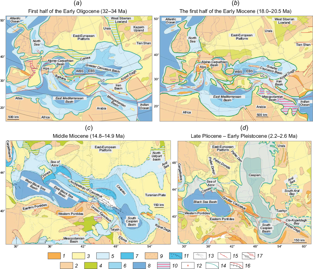
Fig. 2. Paleogeographic schemes of Western Eurasia (after [Popov, Patina, 2023]).
1 – mountains; 2 – uplands; 3 – lowland; 4 – lagoons and lakes; 5 – shoal; 6 – deep-water shelf; 7 – basins; 8 – bathyal; 9 – volcanic massifs; 10 – gypsums; 11 – basin slopes; 12 – volcanos; 13 – river deltas; 14 – land-sea coastal border; 15 – normal faults; 16 – thrusts: active within a specified period (red-colored) and at a later time (black-colored); 17 – strike-slips active within a specified period and at a later time. WBS – West Black Sea basin, EBS – East Black Sea basin, LS – Lesser Caucasus.
Ciscaucasia and the Middle Caspian are an oil-bearing regions, whose most important oil-source complexes rightfully include the Maikop Formation since the earliest publications of I.M. Gubkin [Gubkin, 1912, 1913]. For more than 110 years passed since that time, the views on the properties of oil-source rocks of the Maikop formation have been fully justified. Over the past two decades, deep boreholes have been drilled in Ciscaucasia and the Middle Caspian; the geochemical and pyrolytic data have been accumulated on the properties of oil-source rocks and on the degree of their transformation, high-resolution seismic studies have been conducted, etc. This has yielded high-resolution data on seismic stratigraphy for the entire region.
In parallel, the practice of geological research has been expanded by the introduction of new technologies, such as:
(1) seismic tomography identifying local structural details of the Earth’ crust and upper mantle;
(2) U-Pb zircon dating of the magmatic bodies which allows estimating their age with an accuracy of 1–2 Ma and even higher and sometimes reconstructing the multi-stage history of initiation of high-grade magmatic and metamorphic complexes;
(3) low-temperature thermochronometry including fission track and other methods providing the information on the time uplift history of the area;
(4) U-Pb dating of single detrital zircon grains from clastic sediments yielding information on the primary source areas of detrital material transported to the basin which allows to reconstruct the sediment flow directions.
The recently obtained geological-geophysical data on the Black Sea-Balkan-Anatolian-Caspian megaregion have provided new ways of looking at the onset time and mechanism of the GC orogen uplift, genetic type of the Ciscaucasia troughs and Ciscaucasia trough-fill history, as well as an opportunity to propose a new interpretation of well-known facts. The main objective, as well as the main content of this paper, is to syntheze new data on the Black Sea-Balkan-Anatolian-Caspian megaregion with an emphasis on the West Caucasus and western Ciscaucasia (Kuban trough), to analyze data coherency and accordingly:
(1) to show that the opinion of L.A. Vardanyants, who assigned the initiation of the GC as a high-mountain region to the period not earlier than the Quaternary, has been confirmed by new factual and up-to-date materials;
(2) to give reasons for the fact that a rapid uplift of the GC is an isostatic response to the Pliocene delamination of the lithospheric fragment beneath the central GC;
(3) to emphasize an important role of the regional Crimea-Caucasus-Kopetdagh strike-slip fault zone in formation of the present-day geomorphological appearance of the GC;
(4) to use the Kuban trough (western segment of the Ciscaucasia trough system) data to substantiate the assignment of the basin, accumulated the pre-Quaternary Ciscaucasia trough-fill sediments, to the category of the continental marginal sedimentary basins ("pericratonic troughs", as termed by [Muratov, 1972]);
(5) to show that the clastic sediments, transported by water flows from the East European and Scythian platforms and adjacent folded belts, primarily filled this basin in the Cenozoic;
(6) to give reasons for the fact that the Kuban trough underwent transformation from pericratonic to piedmont trough, which started to accumulate the GC-derived sediments not earlier than the Late Pleistocene.
Addressing these issues has important practical implications. Knowing of the onset time of the GC uplift and genetic type of the Ciscaucasia troughs in the pre-Late Pliocene – Quaternary is in an obvious way directly related to discovery prospects of some crude ore and hydrocarbon materials in the western segments of the GC and Ciscaucasia. These are focused on identifying sources and potential scales of Rare-Earth-titanium placers in Ciscaucasia, performing metallogenic regional analysis, developing strategies for the discovery of new oil and gas accumulation zones etc. On one hand, the Miocene substantially quartzous sands and sandstones in Ciscaucasia are good oil reservoirs, but on the other hand, they host Rare-Earth-titanium placers. If it is considered that the pre-Late Pliocene – Quaternary Ciscaucasia troughs are pericratonic basins, then one has to admit the clastic material, composing these sands and sandstones, to be derived not from the GC complexes but from the cover and basement complexes of the East European and Scythian platforms north of Ciscaucasia. A new interpretation of the evolution of the northern parts of the Black Sea-Balkan-Anatolian-Caspian megaregion, as well as of the filling mechanism for the Kuban and other Ciscaucasia troughs, requires a radical revision of the a priori conditions of numerical models for evolution of the generation-accumulation hydrocarbon systems therein.
The GC orogen is a small peripheral fragment of a vast mountainous area – the Alpine-Himalayan belt. This area structure is primarily composed of irregularly deformed Mesozoic and Cenozoic complexes and secondarily of the Paleozoic and Precambrian folded formations. Tectonically, this belt formation is now commonly interpreted as a direct consequence of the collision between the northern Arct-Laurasia and Gondwana continental masses [Stampfli, Borel, 2002] (Fig. 3).
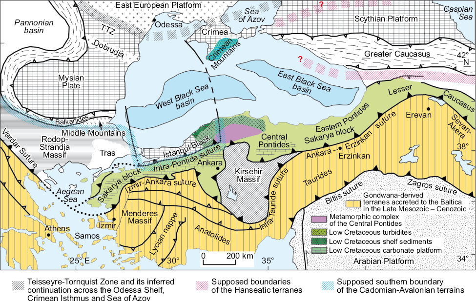
Fig. 3. Major geological-tectonic structures of the Black Sea-Balkan-Anatolian-Caspian megaregion (simplified after [Okay et al., 2001] and modified after [Okay et al., 2013]).
The Neoproterozoic and Paleozoic southern and southwestern margins of the Baltica paleocontinent – Precambrian basement of the East European platform – were bordered by the Tethys Ocean whose lithosphere subducted beneath the Baltica continental margin [Natalin et al., 2012; Okay, Nikishin, 2015; Aygül et al., 2016]. In the Paleozoic, the Baltica became a part of the Arct-Laurussia and later – a part of Arct-Laurasia composite continents [Kuznetsov, 2009; Kuznetsov et al., 2010], and its southern and southwestern margins grew due to the accretion of terranes: either already broken away from the Arct-Laurasia and different parts of the northern Gondwana margin (Hanseatic and Cadomia-Avalon terranes) or formed initially as intraoceanic formations – volcanic arcs, oceanic plateaus, oceanic basin lithosphere relics (Galatian terranes) [von Raumer et al., 2013; Stampfli et al., 2013].
As a result, by the end of the Carboniferous (~300 Ma), a wide band of terranes had been accreted to the southern and southwestern margins of the East European (Baltic) part of Arct-Laurasia. At the end of the Permian and in the Triassic, a large band-like fragment of the continental lithosphere (whose parts are known as Cimmerian terranes) was broken away from the northern Gondwanian margin. The drifting movement of this band-like fragment of the continental lithosphere towards Arct-Laurasia caused the Tethys Ocean to fracture into decreasing Paleo-Tethys Ocean and increasing Neo-Tethys Ocean (Fig. 4).
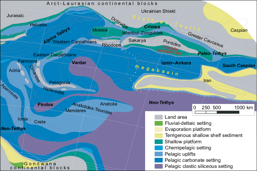
Fig. 4. Paleogeographic scheme of the northern margin of the Tethys Ocean for the Tithonian (simplified and supplemented after [Wilhem, 2014а, 2014b, 2014c]).
Some of the Cimmerian terranes which were broken away from the northern margin of Gondwana (the part of it that now is the northern margin of Southeastern Africa and, perhaps, partially of Arabia) are actively involved in the basement structure of the Southern and Eastern Turkey. They are termed Taurides or sometimes Anatolides-Taurides [Meinhold et al., 2013; Avigad et al., 2016]. The Iranian domain, adjacent to the Taurides on the east, is a fragment of Arabia [Zakariadze et al., 2007; Ustaömer et al., 2013; Moghadam et al., 2017; and references therein].
It is generally considered that the closure of the Paleo-Tethys Ocean gave rise to the formation of suture zones: Izmir-Ankara-Erzincan suture zone in the Anatolian Peninsular, Vardar Zone in the Balkans, and Sevan-Akera ophiolithic belt in the Lesser Caucasus (see Fig. 3; Fig. 5). The Intra-Pontide suture zone resulted from the closure of the Izmir-Ankara basin (sometimes termed Intra-Pontide Ocean) [Bozkurt et al., 2012]). The currently available and reliable geochronological dataset, including the age dates for overpressured complexes and ophiolites, as well as biostratigraphic interpretations of radiolarites in ophiolites, limits the existence of this ocean to an interval of ~255–~65 Ma [Göncüoğlu et al., 2008, 2014; Galoyan et al., 2009; Rolland et al., 2009, 2016; Çelik et al., 2011; Akbayrama et al., 2013; Özdamar et al., 2013]. The Pontides are the Triassic-Cretaceous complexes and relics of their composed paleostructures formed in the Izmir-Ankara oceanic basin and in its margins. The Pontide distribution area includes three different terranes – Strandja (Thrace basin basement), Istanbul (sometimes termed Istanbul-Zonguldak) and Sakarya. The Pontides are sometimes also subdivided geographically into Western and Eastern Pontides.
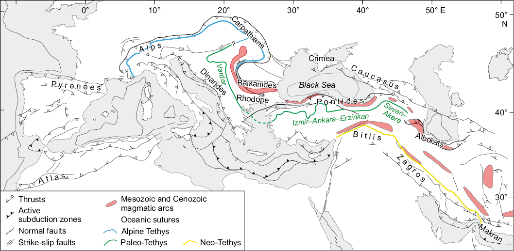
Fig. 5. Location of relics of the Mesozoic and Cenozoic volcanic arc settings and sutures on the map of the Mediterranean-Caspian region (simplified after [Gallhofer et al., 2015]).
The Bitlis-Zagros suture zone is a result of the closure of the Neo-Tethys Ocean – the Late Cenozoic collision zone between the Arabian and North Eurasian plates [Okay et al., 2010; Moghadam et al., 2017; Yılmaz et al., 2013; Chiu et al., 2013] (see Fig. 3; Fig. 5).
During the Mesozoic and Cenozoic, the Tethys Ocean experienced the existence of a vast volcanic arc system (Fig. 5). However, the currently available data on the Jurassic magmatic rocks, common in the GC and Crimean Mountains, testify to rhyolite-basaltic (bimodal) character of this magmatism [Morozova et al., 2017; Gerasimov et al., 2022; Kaigorodova, Lebedev, 2021, 2022; Kuznetsov et al., 2022; Romanyuk et al., 2024]. Such magmatism does not seem to be directly related to arc (suprasubduction) volcanic activity.
During the Late Cretaceous and Early Cenozoic, the northern Black Sea part of the Black Sea-Balkan-Anatolian-Caspian megaregion underwent submeridional extension accompanied by large-scale shears and their paragenetically connected folds, faults, and magmatism. That gave rise to the formation of the Black Sea basin and its deep-water West and East Black Sea basins with oceanic-type crust (their formation time is Late Cretaceous – Eocene) [Hippolyte et al., 2010, 2018; Nikishin et al., 2015а, 2015b, 2015с; Sosson et al., 2016] (Fig. 6). The Istanbul Block was broken away from the Dodrogea-Moesia and separated from it by the Black Sea basin (see Fig. 3).
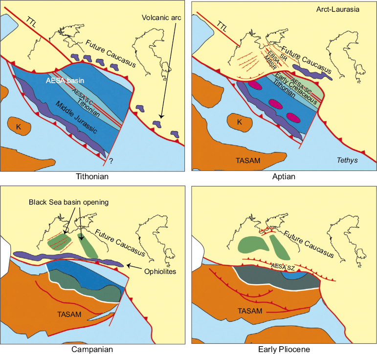
Fig. 6. Tithonian to Early Pliocene paleotectonic reconstructions of the Black Sea-Balkan-Anatolian-Caspian megaregion, illustrating the formation of the Black Sea basins (dark-green filling), after [Sosson et al., 2016].
AESA basin – Ankara-Erzincan-Sevan-Akera basin; TASAM – Analolides-Taurides + South Armenian microplate; K – Kirsehir Block; SR – Shatsky Rise; MBSR – Mid-Black Sea Ridge; EBSA – East Black Sea basin axis; AESA SC – Ankara-Erzincan-Sevan-Akera spreading center; AESA SZ – Ankara-Erzincan-Sevan-Akera suture zone; TTL – Teisseyre-Tornquist Line.
After the Arct-Laurasian and Gondwanan continental masses had joined each other, the Black Sea-Balkan-Anatolian-Caspian megaregion became the northern part of a vast epicontinental basin (megabasin) named Paratethys. This megabasin was a complex system of basins and sub-basins joined to each other by narrow straits (see Fig. 2). Damming straits occasionally interrupted the connection of basins and sub-basins with the Mediterranean sector of the Global Ocean and caused drastic changes in hydrological regime, catastrophic sea level drops, as well as change from marine to freshwater faunal communities etc. [Popov et al., 2009, 2010; Popov, Patina, 2023].
In the first approximation, the structure of the Caucasus region (Fig. 7) consists of four main tectonic units – Greater (North) and Lesser (South) Caucasus Mountains and their separating Central Caucasus depression – Rioni and Kura basins or Rioni-Kura trough system (sometimes named Transcaucasia). Northward of the Greater (North) Caucasus Mountains, there is the Ciscaucasia trough system.
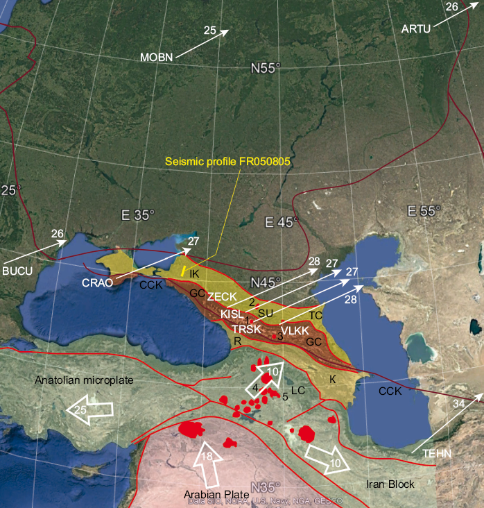
Fig. 7. Google Earth image-based scheme of the plate motion in the Black Sea-Balkan-Anatolian-Caspian megaregion.
Volumetric white arrows and numbers therein show displacement directions and displacement rates (mm/yr) for the structures of the Anatolian Peninsular, Lesser Caucasus, Iranian Block and Arabian Plate (after [Lukk, Shevchenko, 2019]). Thin white arrows and nearby numbers show displacement directions and displacement rates (mm/yr) for the stations in Russia (CRAO – Crimea, MOBN – Obninsk, ARTU – Arti, ZECK – Zelenchuk, KISL – Kislovodsk, TRSK – Terskol, VLKK – Vladikavkaz), Romania (BUCU) and Iran (TEHN) (after [Milyukov et al., 2015]). Pliocene-Quaternary magmatic fields are red-filled, 1 – Elbrus, 2 – Pyatigorsk intrusions; 3 – Kazbek, 4 – Aragats, 5 – Ararat. Troughs: IK – Indol-Kuban, TC – Tersk-Caspian, R – Rioni, К – Kura, SU – Stavropol Uplift, GC – Greater Caucasus, LC – Lesser Caucasus, CCK – Crimea-Caucasus-Kopetdagh strike-slip fault.
The GC Mountains and Ciscaucasia are characterized by a wide distribution of Mesozoic to Cenozoic sedimentary strata formed in the northern part of the Eastern Paratethys. Ciscaucasia consists of the Kuban trough (eastern part of the Indol-Kuban trough) in the west and Tersk-Caspian trough in the east, separated by the Stavropol uplift.
The Pre-Jurassic basement of the GC was formed in the Paleozoic due to accretion of terranes, broken away from the northern Gondwanan margin and/or emerged in the Paleotethys Ocean. The structural basement of the Lesser Caucasus is composed of the complexes of marginal oceanic and/or intraoceanic genesis, formed in the Paleotethys Ocean and in its margins. According to M.L. Kopp [Kopp, 2004], different parts of the present-day Caucasus region were formed structurally at various times: the Lesser Caucasus – in the Late Cretaceous – Early Paleogene, the central segments of the GC – in the Paleogene, and the areas of northwestern and southeastern dips of the GC – in the Middle Neogene – Quaternary.
The present-day GC structure reveals the southern and northern slope domains separated by the so-called Main Caucasian fault. The northern slope or northern domain of the GC consists of more fractional north-south structural units (Fig. 8):
– Main Range zone including the Pereval and Elbrus subzones;
– Peredovoy Range zone;
– Bechasyn zone, earlier named Laba-Malka zone or North Caucasus marginal massif [Milanovsky, Khain, 1963; Milanovsky, 1968].
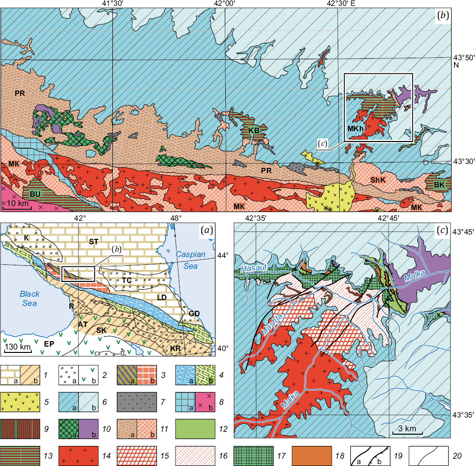
Fig. 8. Schematic illustrations of the general structure of the Caucasus and adjacent regions (a), tectonic zoning of the central and eastern parts of the Peredovoy fault zone, Bechasyn zone and adjacent areas (b) and the geological structure upstream of the Malka River (c).
(a) – tectonic scheme of the Greater Caucasus and adjacent areas ([Kuznetsov et al., 2025], after [Khain et al., 1998]). 1: а – epi-Hercynian Scythian plate: Stavropol arch (ST), Limestone Dagestan zone (LD), b – Cadomian Transcaucasia microcontinent; 2: а – Cenozoic troughs: Kuban (KB), Tersk-Caspian (TC), Gusar-Divichi (GD), Rioni (R), Kura (KR), b – Eastern Pontides (EP) and Lesser Caucasus structures: Adjara-Trialet (AT) and Somkheti-Karabakh (SK) zones; 3 – high-mountain (axial) part of the Greater Caucasus: а – Preredovoy Range zone, b – Main Caucasian Range zone; 4: а – schist zone of the southern slope of the Central Caucasus and Main and Lateral ranges of the East Caucasus, b – flysch zones of the West and East Caucasus. (b) – tectonic scheme of the central and eastern parts of the Peredovoy Range (PR) zone, Bechasyn zone, and adjacent areas. Simplified after [State Geological Map…, 2004, 2021]. (c) – scheme of the geological structure of the upstream part of the Malka River (simplified after [State Geological Map…, 2004]).
5–7 – neoautochthonous structures: 5 – Elbrus volcanic center (Pliocene – Holocene); 6: а – syn-Alpine North Caucasus monocline (Callovian – Paleogene), b – syn-Cimmerian discontinuously folded Laba-Malka zone (Synemurian – Bathonian); 7 – fragments of the Hercynian Molasse trough (Carboniferous – Permian); 8–9 – Cimmerian paraautochthonous structures: 8: а – Phiya-Arkhyz and Arkhyz-Klych blocks of the Arkhyz-Guzeripl depression (Synemurian – Aalenian), b – Middle Jurassic Sancharo-Kardyvach gabbro-diorite-granite massif; 9 – Mesozoic (?) intrusions of the plagiogranite-doleritic complex; 10–12 – allochtonous structures: 10 – ophiolitic nappes: а – undissected crustal complexes, b – mantle tectonites; 11: а – Hercynian nappes composed of the Silurian-Triassic strata, b – pre-Hercynian (?) nappes of the Makersk (MK) zone, Kuban (KB) block and Shaukamnysyrt (ShK) zone, composed of presumably Precambrian metamorphites; 12 – Lakhran allochthone, Silurian – Early Devonian sedimentary strata; 13–18 – autochthonous structures: 13 – pre-Hercynian, primarily metamorphic, complexes of the Buulgen block (BU) of the Main Range zone, Kuban (KB) and Baksan (BK) blocks of the Peredovoy Range zone, Malka-Khasaut (MKh) area of the Bechasyn zone; 14 – Late Paleozoic (Carboniferous) granitoids: Ullukam, Belaya Rechka and Malka complexes; 15 – metamorphic Khasaut group; 16 – metamorphosed Khasaut group; 17 – Urlesh formation; 18 – Manglay formation and Cheget-Lakhran Suite unstratified; 19: а – faults, b – thrusts; 20 – zonal boundaries for (а, b) and geological boundaries for (c).
Thin shallow-marine or even subcontinental coal-bearing Upper Mesozoic strata, defined clearly within the Bechasyn zone, compose the gently north-dipping monocline and overlap the intensively dislocated and unevenly metamorphosed Upper Precambrian and Paleozoic strata and their associated hyperbasites and granitoids. This part of the northern slope of GC orogen is essentially the Alpine uplift-involved structural element of the Ciscaucasian part of the epi-Hercynian Scythian platform. That is how this part of the GC orogen (Laba-Malka zone) was described by E.E. Milanovsky: "During the greater part of the Alpine cycle, this zone belonged to the epi-Hercynian southern Ciscaucasia platform, but only at the end of this cycle it was involved in the Greater Caucasus uplift as its plainly structured wing…" [Milanovsky, 1968, p. 15]. "During the Malm and in the beginning of Cretaceous, the Northern Caucasus trough was located primarily in the northern wing ˂…˃ of the Greater Caucasus, but further north in the central Caucasus, in the southern part of the epi-Hercynian platform (Laba-Malka zone)" [Milanovsky, 1968, p. 34, and further ˂…˃ (in Oligocene) "most intensive uplift, undergone by the Central segment of the Greater Caucasus, involves adjacent parts of the epi-Hercynian platform and middle massif: the Laba-Malka zone on the north, transforming into monoclinally structured wing of the Greater Caucasus Mountains" [Milanovsky, 1968, p. 38].
The western (northwestern), central and eastern (southeastern) segments, commonly distinguished along the GC strike, obviously differ from each other by the orogen width, its relief height, and hypsometry of the top of the pre-Alpine basement (see Fig. 7; Fig. 8). The maximum width and relief height of the orogen are typical for the central segment. The Pre-Mesozoic crystalline basement is exposed in places in the axial zone of the central segment of the GC at a height of more than 2 km. The Jurassic and Cretaceous formations are predominantly found in the axial zone of the western and eastern segments.
Cross-sectional view of the present-day GC Mountains clearly shows their asymmetry that consists of the plainly structured, relatively wide northern wing and the complex southern wing been characterized by the southward-verging folded overthrusts.
The results obtained using different seismic methods (deep seismic sounding (DSS), various modifications of seismic reflection method (SRM), microseismic sounding method (MSM)) have not yet provided the opportunity for unambiguous interpretation of the internal structure of some anomalously thin crustal zones of the GC, including the Main Caucasus Thrust zone. Seismic images of the environment, obtained through different methods, do not lend themselves to obvious joint interpretation (Fig. 9). In particular, neither seismic imaging nor drilling survey has yet yielded reliable evidence of a low-angle thrust for the tectonic zone associated with the Main Caucasus fault (thrust) zone.
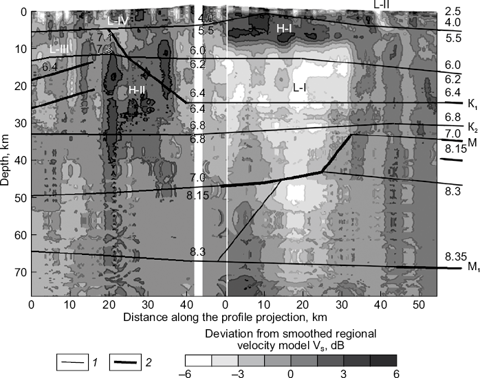
Fig. 9. Comparison of the results for microseismic sounding along the profile in the Ossetian sector of the Greater Caucasus [Gorbatikov et al., 2015] with those along the Stepnoe – Bakuriani DSS velocity profile [Pavlenkova, 2012]. Numbers show seismic wave velocities in km/s. 1 – boundaries between different seismic-velocity layers; 2 – reflecting segments. К1 and К2 – intracrustal boundaries; М – Moho boundary, М1 – intramantle boundary. A white vertical band along the microseismic sounding profile corresponds to the Roki tunnel location.
The scientists who study the Caucasus region still have no consensus about the Alpine (syn-Alpine) structure of longitudinal segments and transverse zones of the GC, as well as about their formation settings. In the literature, there are very different estimates for scales and ways of the contraction of the Earth’s crust that accompanied the formation of the present-day GC orogen [Yakovlev, 2015]. There is a widespread perception that the GC is composed of thick-skinned (to 15–20 km) nappes gently sloping to the north. The upper nappe is composed of ancient crystalline basement rocks exposed in the Main Range and coming into contact with their underlying Mesozoic and Cenozoic rocks along the tectonic surface – Main Caucasus Fault [Khain, 1984; Dotduev, 1986; Vasey et al., 2020, 2023; and others] (Fig. 10). In contrast, the geologists with a large Caucasus fieldwork experience have reasonably believed and continue to believe that there was only moderate contraction of the crust in the axial zone of the central segment of the GC at the Alpine stage. No evidence was found for large-amplitude thrusting, tectonic coupling of the Earth’s crust or subduction at that time [Adamiya et al., 1989; Leonov, 2007; Somin, 2000, 2021; Adamia et al., 2011].
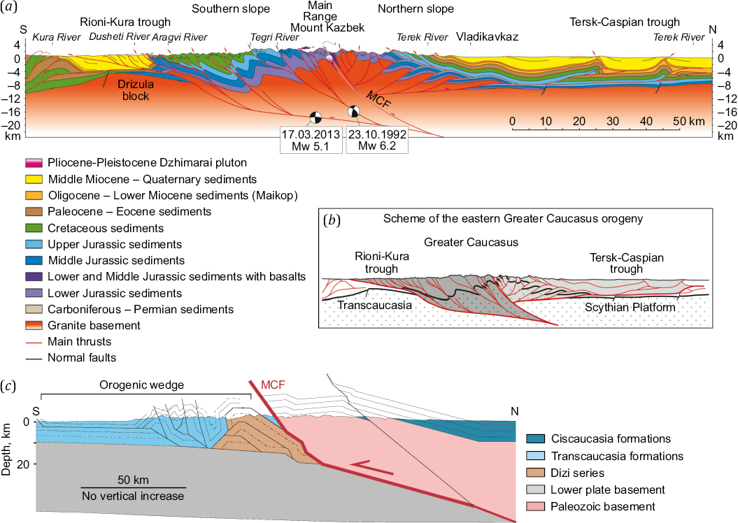
Fig. 10. Structural models of the eastern part of the Central Greater Caucasus and adjacent regions (Rioni-Kura and Tersk-Caspian troughs).
(а) – seismogeological cross-section, (b) – generalization (а) (after [Mossar et al., 2022]); (c) – conceptual model (after [Vasey et al., 2020, 2023]). MCF – Main Caucasus fault.
The substantially alternative views are presented in [Patina et al., 2017]. The authors of this article believe that intense folding and faulting (up to the formation of large overfolds and south-verging thrusts) in the southern slope zone of the GC are due to the Late Cenozoic right-lateral transpression regime therein. The most prominent example of these deformations is the Crimea-Caucasus-Kopetdagh strike-slip fault zone (Fig. 11), running through the Apsheron Threshold and southern slope zone of the GC from the Kopetdagh to the Crimean Mountains. It spatially coincides with the traditionally identified Main Caucasus fault zone, is traced throughout the southern slope of the GC, with displacement of 150 to 200 km thereon [Kalugin, 1946; Gorshkov, 1947; Patina et al., 2017]. Presently, 26–28 mm/yr right-lateral motions along this strike-slip fault zone are supported by GPS observations [Milyukov et al., 2015]. The right-lateral displacements under compression along this zone gave rise to the formation of the Main Range structure and caused erosion dissection of the present-day GC orogen relief. Nowadays these views on the GC history and formation mechanism find more and more supporters that also include the authors of the present paper.
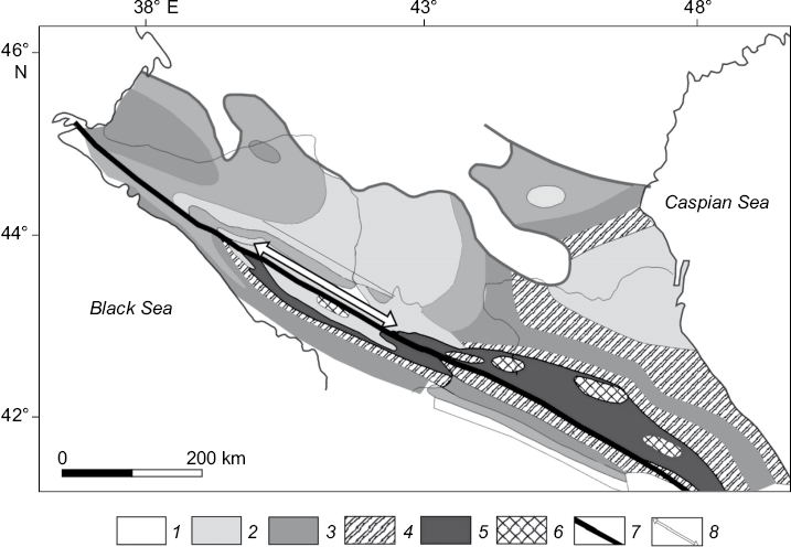
Fig. 11. Zones of postdiagenetic transformations of the Lower Jurassic organic matter in the Greater Caucasus and Ciscaucasia (after [Patina et al., 2017]): 1 – mesocatagenesis МC2, 2 – mesocatagenesis МC3, 3 – mesocatagenesis МC4–5, 4 – apocatagenesis АC1–2, 5 – protometagenesis PM, 6 – mesometagenesis ММ, 7 – Crimea-Caucasus-Kopetdagh strike-slip fault boundary on the surface, 8 – Crimea-Caucasus-Kopetdagh strike-slip fault amplitude ~200 km.
Note that most of the structural models of the GC, including its northwestern slope, were initially created within the imbricate fault structure of the GC [Popkov, 2006; and many others.]. However, in some structural and evolutionary models of the western segment of the GC, based on fragmented factual data without involving a-priori ideas about the deformation style, a general structure of this orogen corresponds almost entirely to a large-scale flower-shape structure formed around the transcrustal shear zone with some additional compression. One such example is shown in Fig. 12. As well as [Patina et al., 2017], we believe that the present-day appearance of the GC (and the structure of the northern part of the Black Sea-Balkan-Anatolian-Caspian megaregion as a whole) is largely a result of motions and deformations in the extended post-Pliocene Crimea-Caucasus-Kopetdagh right-lateral strike-slip fault zone, superimposed on the heterochronous structures of the Alpine-Himalayan belt and southern Scythian-Turan platform.
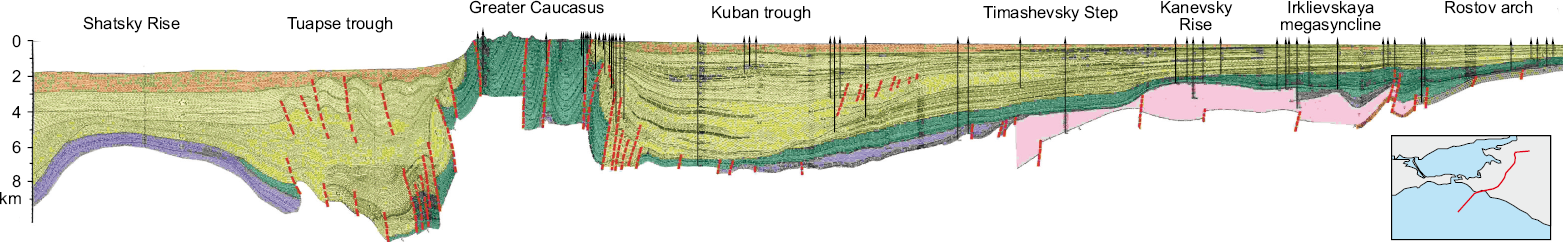
Fig. 12. Seismogeological section across the western part of the Greater Caucasus and adjacent regions (Tuapse and Kuban troughs). Drawn by A.V. Khortov (Shirshov Institute of Oceanology of RAS). The inset shows the profile location.
Therefore, the present-day GC Mountains are the element of the northern (hanging) wall of the Caucasian segment of the Crimea-Caucasus-Kopetdagh right-lateral strike-slip fault zone representing the uplifted block of rocks, with some of them deformed as far back as the Cimmerian and at ealier evolutionary stages of the region. The current look of the GC, at least of its western (northwestern) segment, did not come directly from the frontal collision between Arabia and Eurasia, but is largely a result of postcollisional processes that did not emerge until the Pliocene or more likely until the very beginning of the Pleistocene.
The probable mechanisms of rapid uplift and subsidence of single crustal blocks, during the several million years, were dealt with in a number of E.V. Artyushkov papers [Artyushkov, 1998, 2010, 2012; Artyushkov, Chekhovich, 2023]. Rapid crustal subsidence without significant extension (formation of deep sedimentary basins) may cause lithospheric phase transitions (for example, eclogitization). The rapid crustal uplift may be due to tectonically caused rapid mantle fluid infiltration into the lithosphere, which drastically reduces the viscosity of a substance [Kiselev et al., 2015]. Such processes in particular may occur during delamination of the lithospheric fragment into the mantle and its replacement by the asthenospheric substance. The episodes of delamination of the lithospheric fragments into the mantle are described and studied in different regions of the world: beneath the southern edge of the Sierra Nevada batholith, beneath the Mojave Desert; beneath the Western Cordillera, Altiplano-Puna Plateau and western edge of the Eastern Cordillera; beneath the Menders Massif in the central Anatolian Peninsular; beneath the northeastern Anatolian Peninsular; beneath the Jinsha Suture in the Northern Tibet, and beneath the Quiantang and Lhasa blocks in the Southern Tibet, see review in [Romanyuk, Tkachev, 2010; and others].
The reference object, namely the most reliably and thoroughly studied object, is likely the Pliocene episode of delamination beneath the southern edge of the Sierra Nevada batholith (Fig. 13). Seismic tomography of the upper mantle beneath this region revealed a high velocity zone at 100–250 km depth, similar in shape to a cylinder with a radius of about 60 km and named "mantle drop" [Zandt et al., 2004].
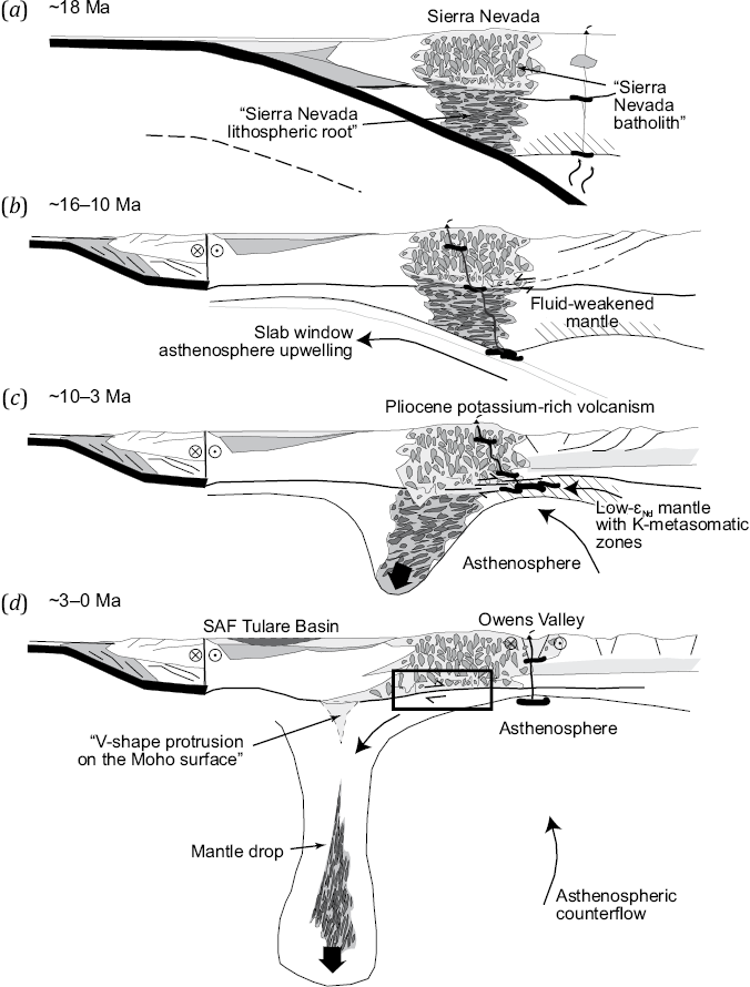
Fig. 13. A delamination model for the lithospheric root from beneath the Sierra Nevada batholith (after [Zandt et al., 2004]).
(а) – the subduction of the Juan de Fuca Plate underneath the North American continental margin where the relic Late Mesozoic volcanic arc lies in the form of the Sierra Nevada batholith, underlain by the dense garnet-pyroxene rocks. At the back of the batholith, there is the suprasubduction volcanic zone. (b) – the opening of a slab window, fingering of hot asthenosphere underneath the continental margin, strike-slip fault activity in the San-Andreas fault system, beginning of destabilization of the dense rocks underlying the Sierra-Nevada. (c) – Initial phase of collapse of the destabilized dense rocks, underlying the Sierra-Nevada, into the mantle, accompanied by pulse of potassium-rich volcanism. (d) – the main phase of collapse of the lithospheric material into the mantle where it acquires a "mantle drop" shape; formation of the Tulare basin and V-shaped protrusion on the Moho surface above the downwelling zone; geothermal activity in the extension area at the eastern margin of the Sierra-Nevada (Owens Valley, Panamint and others). The black rectangular contour shows the area of crust-bottom anisotropic zones associated with strike-slip fault activity (active detachment faulting).
Geologically, the Great Valley and the Sierra Nevada Mountains are the relics of the forearc basin and volcanic arc, formed in the Mesozoic, when the Farallon Plate subducted beneath the western margin of the North American Plate. The Great Valley throughout the Cenozoic (and at present) has been a sedimentary basin. The Sierra Nevada basement is primarily composed of the Late Cretaceous (~85 Ma) and older granitoids, and of various metamorphic complexes, unconformably overlain by the Eocene and younger sedimentary and volcanic formations. Due to low crustal seismic velocities beneath the Sierra Nevada (<6.2 km/s), this entire block is interpreted as a granite batholith [Fliedner et al., 2000; Ducea, 2002; and references therein]. It is considered that the thick granite crust and mafic (in places ultramafic) crustal root were formed in the Late Cretaceous, just as most of the Sierra Nevada batholith was [Ducea, 2001]. Garnet-pyroxene paragenesis of the batholith crust makes it denser as a whole and some of its fragments – much denser than the standard lithospheric mantle, and transforms the entire system into a gravitationally unstable structure.
The results of a study of numerous crustal and mantle xenoliths from the Miocene and post-Miocene lavas provide direct evidence of change in the lithospheric composition beneath the Sierra Nevada during this period [Ducea, Saleeby, 1998] (Fig. 14). Xenoliths from the Miocene volcanites mark the three-layer lithospheric column consisting of (1) 30–35 km thick granite batholith underlain by (2) lower crustal layer and lithospheric mantle up to 70 km in thickness, mafic or ultramafic in composition, characterized by garnet paragenesis, and its underlying (3) mantle peridotites. The Late Pliocene and Quaternary volcanites do not contain garnet-bearing xenoliths, and 35 to 70 km deep lying xenoliths indicate the presence of mantle peridotites. These data are in good agreement with the results of the detailed seismic studies, which yield seismic wave velocities of 7.4–8.2 km/s for the mantle layer directly beneath the Moho boundary and relatively low seismic wave velocities of~7.8 km/s for the intermediate layer, thus implying high temperatures therein [Fliedner et al., 2000]. Compositional changes in the lithospheric column should have occurred 3–10 Ma [Ducea, Saleeby, 1996, 1998]. That is a very strong argument in favor of delamination of the lower crust and its underlying lithospheric mantle in the same period. A short-term pulse of potassium-rich (to potassium-ultrarich) and low-εNd volcanism with an age of ~3.5 Ma is thought to be related to the initiation of delamination [Manley et al., 2000; Farmer et al., 2002]. Magmatism dating-based partial replacement of the lithosphere with asthenosphere spatially concides with the Pliocene – Holocene uplift of the Sierra Nevada, caused by the change in the buoyancy of the upper mantle [Jones et al., 1994, 2004].
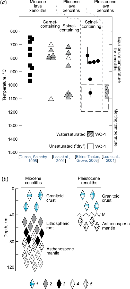
Fig. 14. Tectonomagnetic stratification of the Miocene and Pliocene-Quaternary lithosphere of the Sierra Nevada based on the lava and xenolith research.
(а) – equilibrium temperatures for xenoliths from the Neogene-Quaternary lavas (dashed square shows the data reported in [Ducea, Saleeby, 1998] for the post-Miocene lavas) and magma melting temperature of sample WC-1. After [Ducea, Saleeby, 1998; Lee et al., 2001; Elkins-Tanton, Grove, 2003]; (b) – a schematic view of the Miocene and Pleistocene lithospheric columns marked by xenoliths. 1 – granitoid crust; 2 – 3 – lithospheric root, composed largely of garnet pyroxenites (2 – low-Mg, 3 – high-Mg); 4 – 5 – asthenospheric mantle at temperatures of 700–900 °C (4) and 1000–1200 °C (5). After [Ducea, Saleeby, 1998; Lee et al., 2001, 2006; Elkins-Tanton, Grove, 2003].
Another example is the area of the Central Andes in the western margin of the South America. High-precision seismic tomography [Graeber, Asch, 1999; Schurr et al., 2006] (Fig. 15), petrogeochemical [Avila-Salinas, 1991; Kay et al., 1994] and other [Garzione et al., 2006] data, as well as the thermomechanical modeling results [Sobolev et al., 2007; Quinteros et al., 2008], suggest the possibility of delamination of the lower-crustal and subcrustal lithospheric mantle fragments and their collapse into the mantle beneath some areas of the eastern part of the Western Cordillera, Altiplano-Puna Plateau and western edge of the Eastern Cordillera. The process is still going on.
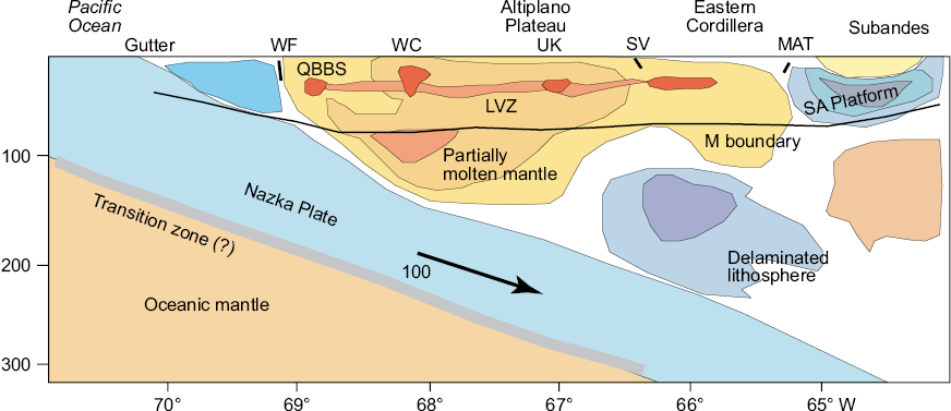
Fig. 15. A conceptual scheme of the seismic structure of the lithosphere of the present-day Central Andes at 21° latitude (after [Heit, 2005]).
The scheme is based on the results of Р and S wave tomography. Moho boundary after [Yuan et al., 2002], WC – Western Cordillera volcanic arc, WF – West Fissure fault, UK – Uyuni-Kenyani fault zone, SV – San-Vicente fault system, MAT – Main Andean thrust, LVZ – low-velocity zone in the upper crust beneath the Western Cordillera and Altiplano Plateau, QBBS (Quebrada Blanca Bright Spot) – area of strong reflections on the seismic waves sections.
At the boundary between the Altiplano Plateau and Eastern Cordillera, there is the Frailes complex – one of the world’s largest ignimbrite complexes, – whose peak activity dates back to approximately 7 Ma [Avila-Salinas, 1991], and the boundary area between the Altiplano and Puna plateaus encompasses the Altiplano-Puna Volcanic Complex (APVC) fields. The internal structure of the complex is dominated by dacites and rhyolites (more than 95 % of the entire volume) – igneous rocks with SiO2 content of 65–70 wt. %.
Magmatic activity in this volcanic complex (ignimbrite bodies, basalt flows, shoshonitic volcanic occurrences etc.) was closely connected with tectonic deformations and covered the area from the Western Cordillera to the western margin of the Eastern Cordillera. It lasted from 27 to 5 Ma with its activity peak found to fall within the end of this period. Then it began to retreat westward; approximately 4 Ma it only occurred up to the western part of the Altiplano-Puna Plateau, and in the last 2 Ma – primarily in the Western Cordillera volcanic arc [Avila-Salinas, 1991; Kay et al., 1994]. These magmatic occurrences are thought to be caused by the collapse of the thick eclogitic root of the South American Platform subducting beneath the Andes [Kay R.W., Kay S.M., 1993] (Fig. 16).
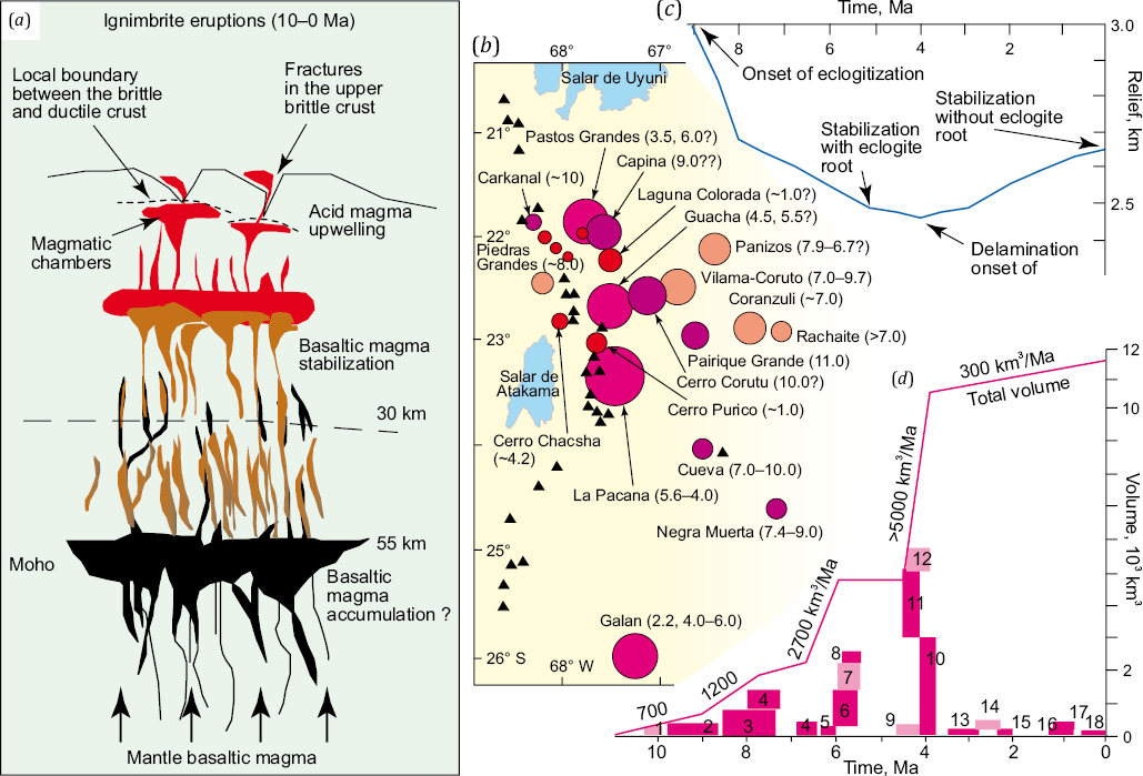
Fig. 16. Neogene-Quaternary ignimbrite magmatism of the APVC.
(а) – a conceptual scheme of formation of giant ignimbrite fields. Basite magma rising from the mantle heated up the crust to promote crustal melting. Tectonic deformations in the upper crust gave rise to the occurrence of numerous fractures in locally transtensional upper crustal horizons along which the magma rose, reached the surface, and flew over vast areas as lava [de Silva et al., 2006]. (b) – location of main magmatic centers (mostly calderas) of the APVC (the larger the circle, the larger the caldera) and their age [de Silva et al., 2006]. (c) – the results of evolutionary modeling of orogenic subsidence and uplift of the Central Andes due to eclogitization of the lower crust of the South American Platform subducting beneath the Andes. The orogenic subsidence occurs under additional loading conditions at first and then the uplift takes place due to the collapse of the thick eclogitic root. Assuming that eclogitization started 10–9 Ma ago, the beginning of delamination of the eclogitic root correlates well with catastrophic ignimbrite-producing eruptions 4–5 Ma ago [Quinteros et al., 2008]. (d) – temporal variation in magmatic activity at the APVC. The curve shows a total volume of products of the known ignimbrite eruptions (less reliable values are lighter-colored, rectangular width – 2σ). 1 – Artola; 2 – Vilama-Corutu I; 3 – Sifon ignimbrite; 4 – Panizos; 5 –Vilama-Corutu II; 6 – Chuhuhuilla; 7 – Pujsa; 8 – Pelon; 9 – Toconao; 10 – Atana; 11 – Puripicar; 12 – Tara; 13 – Juvina; 14 – Patao; 15 – Pampa Chamaca; 16 – Laguna Colorado; 17 – Purico; 18 – Filo Delgado. Numerical values are eruption velocities at major activity stages. Magmatism started 10 Ma ago, its intensity was constantly increasing with time; 5–4 Ma ago there occurred catastrophic events after which the activity has slowed down [de Silva et al., 2006].
The above two and many other episodes of lithospheric delamination occurred in tectonically active regions, which had previously experienced long-term episodes of subduction and/or collision. Such geodynamic settings, in which insufficiently heated lithospheric fragments are rapidly drawn into depth, give rise to the formation of high-density mineral associations and a "solidified" fragment of the lithosphere. Later, under the influence of the external factors, this lithospheric fragment becomes unstable and may collapse into the mantle. Full detachment of the delaminated lithospheric fragment from the overlying crustal block (or coupling loss between the two structures) usually dates back to 1–2 Ma. The episode of delamination is accompanied by short-term episodes of magmatism whose peak activity lasts no longer than several million years. These peak magmatic events more often coincide temporally with detachment of the delaminated lithospheric fragment. After the collapse of the lithospheric fragment, due to isostatic rebound, the overlying crustal block, detached from the thick lithospheric root, undergoes rapid isostatic uplift by 2 km or more.
The data accumulated make it possible to substantiate views according to which slow and long-term collisional compression is not the main cause for the GC uplift that is most likely due to seismic tomography evidence-based rapid isostatic response to delamination of the lithospheric fragment from beneath the Caucasus region [Koulakov et al., 2012; Zabelina et al., 2016] (Fig. 17).
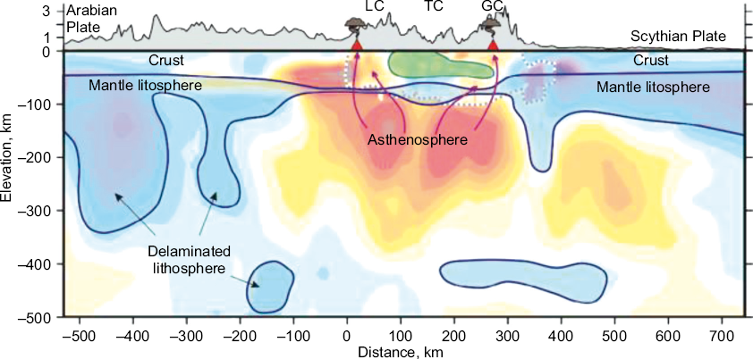
Fig. 17. Seismotomographic model of the crust and upper mantle of the Caucasus region (after [Koulakov et al., 2012; Zabelina et al., 2016]).
Bluish patters show the higher-velocity and denser zones in the mantle lithosphere, green stands for such block beneath Transcaucasia (TC). The central Caucasus region exhibits upwelling asthenosphere and the process of the sublithospheric mantle to asthenospheric matter replacement beneath the Lesser and Greater Caucasus. Red arrows show probable ways of feeding volcanic centers in the Lesser (LC) and Greater (GC) Caucasus.
We would especially like to note that the earliest publication we found on delamination of the fragment of lithospheric mantle beneath the central Caucasus region is [Ershov et al., 1999]. This paper presents an integrated review of the geological-geophysical data on the Caucasus region, including gravity modeling, modeling of the subsidence of the Ciscaucasia troughs, and computational modeling for the elastic flexural part of the lithosphere. In [Ershov et al., 1999], it is shown that (1) topographic load, generated by the Caucasus orogen, is insufficient to explain the deep-seated profiles and history of the orogen-adjacent trough subsidence, reconstructed from a large amount of evidence, and (2) the formation of the present-day high-mountain relief of the central Caucasus requires crustal thickening and removal of the lithospheric root due to some mechanisms – conductive heating, convective removal or delamination. However, by the time of [Ershov et al., 1999] publication, no evidence had yet been found to substantiate the choice of the most appropriate mechanism.
At the moment, a large amount of the Pliocene – Quaternary magmatic occurrences in the Caucasus region has already been dated, as well as a large amount of other characteristics of the Pliocene – Quaternary magmatism has already been obtained. A comparison between these age determinations and delamination of the lithospheric fragment beneath the central Caucasus allows ~2–3 Ma to be considered as the time of detachment of the delaminated lithospheric fragment, which was followed by a rapid isostatic uplift of the Lesser and Greater Caucasus.
The first isotopic dating of the Pliocene volcanic rocks of the GC was obviously performed as far back as the 1990s [Lipman et al., 1993; Zhuravlev, Negrei, 1993; Hess et al., 1993]. By now, the dating, as well as the petrological and isotopic-geochemical studies of the Pliocene – Quaternary magmatic rocks of the GC, is dealt with in a vast number of papers [Milanovsky, Koronovsky, 1973; Koronovsky et al., 1987; Kostitsyn, 1995; Gazis et al., 1995; Kostitsyn, Kremenetsky, 1995; Bogatikov et al., 1998; Grün et al., 1999; Gurbanov et al., 2004; Koronovsky, Demina, 2007; Avdeenko et al., 2008; Lebedev et al., 2004, 2011a; Lebedev, Vashakidze, 2014; Parfenov et al., 2019; Soloviev et al., 2021а, 2021b]. All large Pliocene – Quaternary volcanic occurrences of the GC (see Fig. 7) have been thoroughly researched and reliably dated. In [Bindeman et al., 2021a], consideration is being given to the synthesis and analysis of a large amount of high-precision dating results and isotopic-geochemical data, previously published and newly acquired by the authors for the Pliocene – Quaternary rocks of the GC. We emphasize that high-precision CA-ID-TIMS U-Pb dating of zircons from top and bottom of the Chegem ignimbrite and its associated porphyry yields indistinguishable age spectra recording 160 kyr of magma assembly and differentiation, with 2.9181±0.0014 Ma eruption age as is constrained by the youngest zircon population [Bindeman et al., 2021a]. In general, it is possible to talk about two pulses of magmatism at ~2.92 and 1.98 Ma, related to Chegem and Tyrnyauz, respectively; the Elbrus and Tyrnyaus ignimbrites and granites yielded similar ages at ~1.98 Ma [Bindeman et al., 2021a, 2021b]. This implies that all these magmatic occurrences have a common source probably located near Tyrnyauz [Bindeman et al., 2021a, 2021b]. The Elbrus is characterized by repeated Pleistocene-Holocene volcanic activity, with the latest eruption occurred about two thousand years ago. There are also other well-known magmatic and metamorphic events in the GC during the Pliocene – Holocene [Lebedev et al., 2005, 2006, 2010а, 2010b; Chernyshev et al., 2014; Kaigorodova et al., 2021; Gazis et al., 1995]. In [Chernyshev et al., 2014], it is proposed to distinguish two stages of high magmatic activity of the GC: Middle Pliocene (3–2 Ma ago, after [Bindeman et al., 2021a]) and Early Neopleistocene.
The results for the Lesser Caucasus were summar in [Shalaeva, 2024]. It was stated that the activity of the Aragats volcano consists of four phases: I and II – 0.97−0.89, III – 0.74−0.68, IV – 0.56−0.45 Ma [Chernyshev et al., 2002; Lebedev et al., 2011b]. The Gyumri ignimbrites (Jradzor and Megrashat sections) date back to 0.65–0.70 Ma [Shalaeva et al., 2020]. Therefore, the Gyumri ignimbrite formation can be assigned to the end of phase III of the Aragats volcano activity. The andesibasalts exposed at Kaps date back to 2.25±0.10 and trachyandesibasalts exposed therein date back to 2.1±0.2 and 2.25±0.10 Ma [Shalaeva et al., 2019] and to 2.09±0.05 Ma [Ritz et al., 2016]. The ages of plateau basalts and andesibasalts in Armenia are estimated to be ~2.5–2.0 Ma [Trifonov et al., 2016, 2017] and 3.26–1.80 Ma [Meliksetian, 2012], respectively.
The Arailer volcanic center includes the Arailer volcano (2610 m) and some slag cones. In [Lebedev et al., 2011b], it is supposed that this volcanic center was formed in two stages. The first stage involved squeezing of dacite intrusions, and the second – andesite lava eruptions that could occur synchronously with mafic effusive eruptions south of the Arailer volcano. The andesites and dacites date back to 1.23±0.03 – 1.37±0.04 Ma, the age of the rhyolitic obsidians is estimated to be 1.26±0.05 Ma [Lebedev et al., 2011b]. The basalts of the Kars-Digor Plateau are 1.27±0.05 Ma old [Shalaeva, 2024].
It is also worthy of note that the Akchagyl transgression in the northern Black Sea and Caspian Sea attained its peak at ~2.6 Ma, when the vast areas in the Caucasus-Caspian region were flooded by seawater [Trifonov et al., 2024]. By analogy with regional episodes of the surface subsidence prior to delamination of the lithospheric fragment beneath the Sierra Nevada and Central Andes, one may suppose that the Akchagyl transgression was caused not by the Eastern Paratethys Sea level rise, but by subsidence in the central Caucasus region beneath the lithospheric fragment delaminated later on. This serves as an additional indirect indicator that clarifies the time of detachment of the delaminated lithospheric fragment.
In a number of papers [Ershov, Nikishin, 2004; Trifonov, Sokolov, 2017], the uplift of the Central Caucasus is attributed to the asthenospheric flow propagating from the Ethiopian-Afar superplume. In our view, however, this flow could be a trigger that induced delamination of the lithospheric mantle fragment but it could not be the primary or main cause of the rapid Pliocene – Quarernary uplift in the Central Caucasus.
Rapid Quaternary uplift in the Greater and Lesser Caucasus is also confirmed by the data obtained using traditional methods. In [Shalaeva, 2024], it is shown that the absolute height of the bottom of the Shirak Basin (Lesser Caucasus) did not exceed 250 m in the Akchagyl time (i.e. ~2.6 Ma ago) and is about 1.5 km nowadays. In the eastern segment of the GC, at heights of about 2 km, in the area of Akusha and on the Qusar Plateau near the Suval Dag Mountain, there were found coarse-clastic formations, interpreted as beach relics, which are biostratigraphically dated as Miocene (Meotis or Pont?) [Drobyshev, 1929] and Akchagyl [Trikhunkov et al., 2020], respectively.
Rapid Quaternary uplift in the GC after delamination of the lithospheric root fits naturally with reliably reconstructed tectonic evolution of the Black Sea-Balkan-Anatolian-Caspian megaregion. The Late Miocene – Quaternary tectonics of this megaregion was impacted most by the collapse of the Arabian slab during locking of the subduction zone, marked in the present-day Black Sea-Balkan-Anatolian-Caspian megaregion structure by the Bitlis-Zagros suture approximately 12 Ma ago [Keskin, 2003, 2007; Lei, Zhao, 2007; Zor, 2008] (Fig. 18).
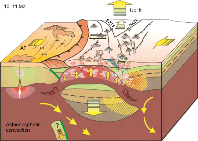
Fig. 18. Illustration of the post-Miocene collapse of the lithospheric fragment beneath the eastern part of the Anatolian Peninsular (after [Keskin, 2007]). AF – African plate, NATF – North Anatolian fault system, SATF – South Anatolian fault system.
The slab collapse caused 1.5–2.0 km uplift of the Turkish-Iranian Plateau and a pulse of volcanism in the eastern part of the Anatolian Peninsular (see Fig. 7), where more than half of the East Anatolian plateau is predominantly covered by subalkaline volcanites [Akyol et al., 2006; Keskin, 2003, 2007]. This volcanism migrated northwards from the Bitlis suture (~11 Ma) to the Caucasus (~3–2 Ma). The Pn wave velocities (typical of the mantle layer directly beneath the crustal bottom – Moho boundary) drop to 7.8 km/s under the western part of the Anatolian Peninsular and to 7.6 km/s under its eastern part [Al-Lazki et al., 2004]. Besides, the seismic velocity drop is recorded partially under the GC [Koulakov et al., 2012; Trifonov, Sokolov, 2018]. This testifies to the lack of the lithospheric mantle layer and its replacement by the asthenosphere under almost the entire Anatolian Peninsular [Vinnik et al., 2016] and partially under the Caucasus.
Subsequent delamination of the lithospheric fragments beneath the Anatolian region and then under the Central Caucasus region caused a rapid reorganization of tectonic motions throughout the Black Sea-Balkan-Anatolian-Caspian megaregion. In particular, an important role was played by newly formed mantle flows along the strike of the collision zone [Kopp, 1997]. Besides, this is reflected in the separation of the new Anatolian microplate along the Anatolian system of faults converging in the Karliova triple junction area (see Fig. 7; Fig. 19). The North Anatolian shear zone separates the Anatolian microplate from the Black Sea block on the west, and the East Anatolian shear zone separates it from the Arabian plate on the southeast [Faccenna et al., 2006]. The locus of shear zone initiation has gradually migrated northwards. It is probable that the shear zones, similar in their motion to the North Anatolian shear zone, were also formed at the Andrysov and Arkhangelsky ridges separating the western and eastern Black Sea basins. Somewhat later there was regional shearing along the mountain ridges of the Southeast Caucasus [Kopp, Kurdin, 1980], and only after that there was formed the regional Crimea-Caucasus-Kopetdagh right-lateral strike-slip fault zone (see Fig. 11), with the major Pliocene – Quaternary movements occurred thereon [Patina et al., 2017]. Active deformation processes are still taking place in the Caucasus and adjacent regions. In particular, intensive deformations are now undergone by the strata filling the Tuapse trough near the coast [Almendinger et al., 2011].
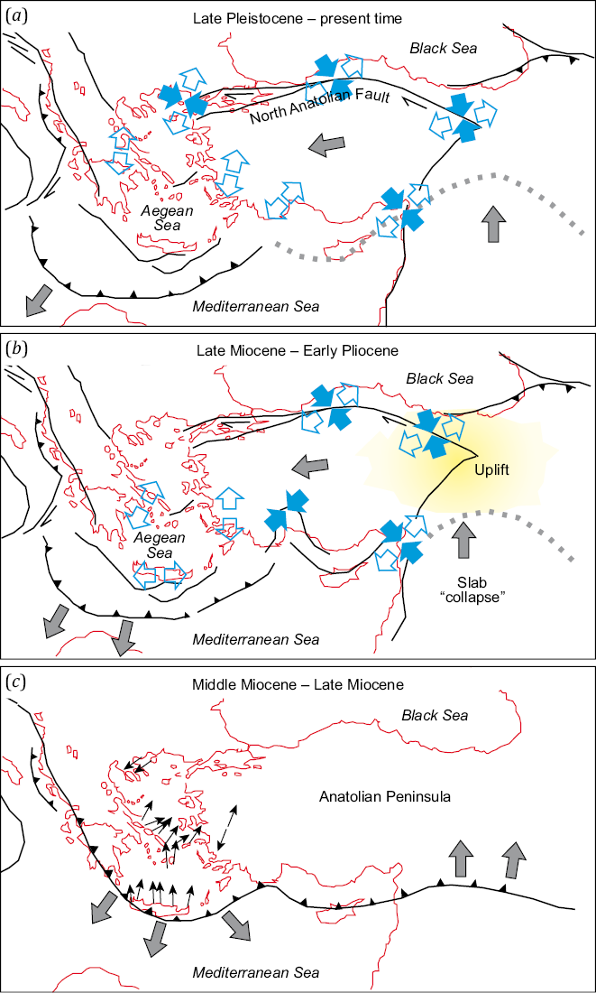
Fig. 19. A scheme of the post-Late Eocene tectonic evolution of the Anatolian-Balkan region and adjacent areas (after [Faccenna et al., 2006]).
Gray arrows show the directions of plate motions; blue filled arrows show the directions of compression, blue empty arrows show the directions of extension in some key regions. The dotted line is an approximate line of the slab collapse; yellow color shows an approximate location of the region, under which the lithospheric mantle fragment has collapsed.
The recent plate tectonic configuration is characterized by the following features (see Fig. 7; Fig. 20).
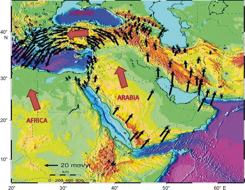
Fig. 20. A scheme of recent plate motions in the Black Sea-Balkan-Anatolian-Caspian megaregion based on the GPS data (after [Kalafat, 2017]).
The "buffer" zone between the large Eurasian, African and Arabian plates contains the Anatolian microplate, which moves westward along the North Anatolian fault zone. This fault zone is a right-lateral strike-slip fault system extending 1400 km from the Karliova triple junction to the Aegean Sea; it then diverges into several faults. The GPS and SLR observations show that the present-day North Anatolian fault zone accommodates almost the entire strike-slip component (22 mm/yr) in the mutual movements of the Anatolian and Eurasian plates [McClusky et al., 2000]. In view of D. Kalafat [Kalafat, 2017], only a small part of the near-meridional pressure caused by the movement of the African and Arabian plates is transferred through the Pontides to the Black Sea block, which seems to experience the near-meridional shortening (contraction) at a rate of ~1 mm/yr. Internal deformations of the central areas of the Anatolian microplate occur at a rate less than 2 mm/yr, and it itself as a rigid block moves counterclockwise around the Euler pole located near the Nile Delta. The southern block of the Aegean Sea moves coherently with the Anatolian microplate towards the Hellenic arc but at a rate higher than that of the central areas of the Anatolian microplate (30 mm/yr against 20 mm/yr) [McClusky et al., 2000; Le Pichon et al., 1995; Kahle et al., 1999]. The difference in velocities is compensated by the extension in the western part of the Anatolian Peninsular. High-velocity movements and extension intensity in the southern Aegean block are thought to be related to the Hellenic trench rollback [Le Pichon, Angelier, 1979; Gautier et al., 1999; Wortel, Spakman, 2000; Jolivet, Faccenna, 2000; Jolivet, 2001].
The northern part of the Caucasus region exhibits a fan-like horizontal velocity vector pattern [Milyukov et al., 2022] reflecting the counterclockwise rotation of the northern limb of the North Azov flexural fault zone and thus the recent strike-slip motions (Fig. 21). The GC and the Kuban trough undergo transverse compression at a rate of up to 1 mm/yr; the Ciscaucasia is dominated by strike-slip motions.
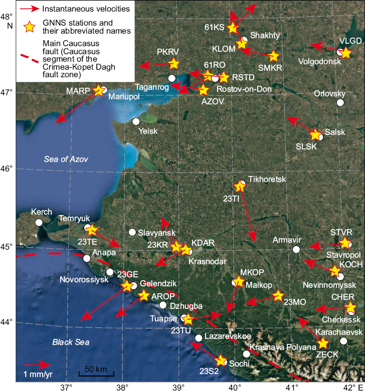
Fig. 21. A scheme of horizontal instantaneous velocity vectors in different parts of the western segment of the Greater Caucasus, West Ciscaucasia and platform-style structures located further north (GNSS station locations and velocity vectors from [Milyukov et al., 2022]).
Regional basic GNSS stations: CHER – Cherkessk, KISL – Kislovodsk, KOCH – Kochubeevskoe, MARP – Mariupol, STVR – Stavropol, RSTD – Rostov-on-Don-1, ZECK – Zelenchukskaya, 61RO – Rostov-on-Don-2. Regional GNSS stations: AROP – Arkhipo-Osipovka, AZOV – Azov, KDAR – Krasnodar-2, KLOM – Shakhty, MKOP – Maikop, PKRV – Pokrovskoe, SLSK – Salsk, SMKR – Semikarakorsk, VLGD – Volgodonsk, 23GE – Gelendzhik, 23KR – Krasnodar-1, 23S2 – Sochi, 23TI – Tikhoretsk, 23TE – Temryuk, 23TU – Tuapse, 61KS – Krasny Sulin.
According to [Milyukov et al., 2015], a typical aspect of the present-day velocity field of the western segment of the GC and North Ciscaucasia is their coherent north-northwestward motion at a rate of 27‒28 mm/yr (see Fig. 7). In the same direction, though at a somewhat lower rate (24–25 mm/yr), occurs also the displacement of the East European platform segment of Eurasia. The mountain structure in the westernmost segment of the GC undergoes longitudinal compression. A large block-like mountain structure in the western GC east of the Tuapse fault zone, however, undergoes lateral compression [Milyukov et al., 2022]. As this takes place, the southerly slope of the western segment of the GC is deformed more intensively than the areas adjacent to Ciscaucasia (Fig. 21).
The following may be noted with regard to the present-day vertical motions in the GC as a whole. The GPS observations show that the Ciscaucasia plains and foothills are characterized by vertical instantaneous velocities of 2.49±2.20 (Vladikavkaz station), 2.89±1.70 (Zelenchukskaya station) and 3.55±1.53 (Kislovodsk station) mm/yr, which increase to 4.36±0.70 mm/yr in the Greater Caucasus Mountains (Terskol station) [Milyukov et al., 2015]. At a constant uplift velocity of about 4 mm/yr over the last 2 Ma, the GC could undergo 8 km uplift.
As far back as a hundred years ago, the founders of domestic geology proposed to consider the GC orogen and the Ciscaucasia troughs to the north of it as a paragenetic connection between the orogen and the trough filled with eroded orogenic-type deposits [Arkhangelsky, 1923, 1927, 1941; Arkhangelsky, Shatsky, 1933; Arkhangelsky et al., 1937]. These views were further developed by M.V. Muratov [Muratov, 1955, 1972], reflected almost unchanged in [Milanovsky, Khain, 1963; Milanovsky, 1968; Khain, 1984], and have survived to the present day [Popov et al., 2009; Nikishin et al., 2010; Popkov, 2010; Beluzhenko, 2011; Popov, Patina, 2023]. All these and other numerous publications interpret the Ciscaucasia trough system as a system of piedmont basins paragenetically connected with the GC mountain structure and predominantly filled with sediment eroded from the structural and compositional complexes of the GC. The beginning of the GC orogenic uplift is there with assigned to the Oligocene or Miocene.
By contrast, since about 2010, the western literature has started to deal with the materials testifying to the fact that the GC had become a high-mountain structure and a tectonic dominant of the Black Sea region not earlier than the end of the Miocene. Thus, the low-temperature thermochronometry data were collected and published showing an abrupt increase in the rate of the Pliocene exhumation of the central segment of the GC [Avdeev, Niemi, 2011]. In [Vincent et al., 2013], there were published analysis results for mineralogical composition of the sandstones from the Cenozoic strata of the northern Black Sea region, which do not have evidence of the Caucasus Mountains erosion in clastic rocks from the Lower Miocene and younger strata of Ciscaucasia.
However, the Russian geological literature still lacks the research evidence and evidence-based conclusions, which are contrary to its generally accepted idea that the Ciscaucasia troughs are the Cenozoic piedmont troughs, predominantly filled with sediment eroded from the Caucasus orogen whose uplift started as early as the Oligocene or Miocene. These views, typical of domestic geology, have proven to be very tenacious regardless of newly acquired data or apparent orographic inconsistences between the GC and Ciscaucasia troughs, since they are considered as a dynamic pair – an orogen and its piedmont trough. Theoretically, if the piedmont trough is formed due to thrusting/orogenic overthrusting on the margin of the platform, then the areas of the maximum thickness of sediments, accumulated in the piedmont trough, should be located against the highest and widest parts of the orogen. From this it follows that the deepest parts of the Ciscaucasia trough should have been located against the most mountainous central part of the GC over 5 km high. However, the GC – Ciscaucasia pair is exactly the opposite of that. Against the central segment of the GC, in Ciscaucasia lies a relatively uplifted block (Stavropol uplift), and the deepest parts of the Kuban trough are located against the westernmost parts of the western segment of the GC somewhat over 0.5 km high. Further west, the Indol-Kuban trough in its Crimean part is only traced up to the central areas of the Crimea where it ends/pitches out, though the Crimean Mountains are continuing/stretching almost another 100 km westwards.
The last decade provided the availability of high-resolution seismic profiling data on the internal structure of the Ciscaucasia troughs. Seismic records revealed numerous details that give information about the sediment flow directions. These are primarily the buried scarps and their associated clinoforms, which are the relics of paleodeltas – consedimentary structures of clastic sediment transport from the erosion and transit areas to a wide shelf. Besides, the high-resolution seismic profiling data clearly show the erosion surfaces (different-order erosional boundaries) and paleoincisions, and other considementary structural forms. The analysis of numerous data on the West Ciscaucasia shows that all Oligocene to Pliocene clinoform bodies and cross-strata concentrated therein are oriented primarily south and less often southwest or southeast, which testifies to a lateral increase in the cross-sectional area only from the side of the East European and Scythian platforms [Kripinevich et al., 1989; Popov et al., 2010; Babina et al., 2022; Polina et al., 2023; Kolodyazhny et al., 2024а, 2024b, 2024c; Patina et al., 2024а, 2024b; Postnikova et al., 2024; Dantsova et al., 2024]. An example of such seismostratigraphic data is presented in Fig. 22. Therewith the Cenozoic strata of the Kuban trough have not shown any clinoform structures oriented north, northeast or northwest.
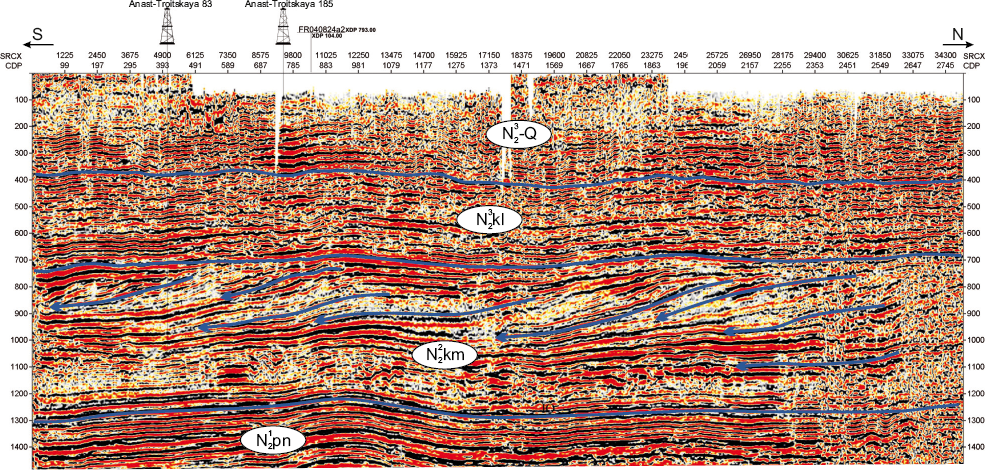
Fig. 22. Seismic profile FR050805, illustrating the internal structure of seismocomplexes of the West Ciscaucasia.
The clinoforms showing the sediment flow direction in the West Kuban trough from the side of the East European Platform up to the Cimmerian are highlighted by the blue lines (after [Dantsova et al., 2024]). See Fig. 7 for the profile location.
The clinoform complexes of the West Ciscaucasia are traced up to the upper stratigraphic levels of the Pliocene – Cimmerian [Dantsova et al., 2024] and even up to those of the Pliocene (Cimmerian) and Quaternary (Kuyalnitsky/Gelasian) [Popov et al., 2010; Kolodyazhny et al., 2024b], whose lower age limit is 2.6 Ma. As for younger strata, the resolution of seismic models drops drastically for objective reasons and does not contribute to reliable identification of clinoforms and other seismostratigraphic markers, which would allow determining the sediment flow directions.
Besides the seismostratigraphic methods, the changes in source areas and sediment flow directions can also be determined with the analysis of U-Pb dating results for detrital zircons (dZr) from clastic rocks. In particular, substantiating changes in the source areas of material which could have filled the Ciscaucasia troughs including the Kuban trough, may involve the U-Pb dating results for dZr, extracted from the sandy rocks of the Late Miocene, Pliocene and Quaternary sedimentary strata filling this trough.
In the West Ciscaucasia, the source areas located on the East European platform (i.e., on the northern basin side) and in the GC orogen (i.e., on the southern basin side) differ significantly in their geochronological characteristics. The GC and the Crimean Mountains ("southern" source areas) have widely distributed Jurassic magmatic formations – potential primary sources of the dZr grains with Jurassic ages of ~168–185 Ma. The "northern" source areas do not have so young crystalline complexes [Kuznetsov, Romanyuk, 2021]. The analysis of the pilot data accumulated to date [Kuznetsov et al., 2024a] has already shown the lack of abundance of the Jurassic dZr grains in sandy rocks of the pre-Pliocene part of the Upper Mesozoic-Cenozoic section of the Indol-Kuban trough. Statistically significant populations of the Jurassic dZr were found in sands from the strata not older than the Pliocene – Pleistocene boundary age [Romanyuk, Kuznetsov, 2024; Shalaeva et al., 2024].
Thus, the pilot study did not reveal the provenance signal of the GC in the studied clastic rocks of the West Ciscaucasia (Kuban trough), which participate in the structure of the strata that are older than the Pliocene. Further thorough study of the clastics participating in the structural cross-sections of the post-Pliocene strata with reliable and detailed biostratigraphy will yield more precise temporal boundaries that mark the beginning of the eroded sediment transport from the GC complexes to different segments of Ciscaucasia. This will make it possible to differentiate between temporal boundaries at which different GC segments began to undergo rapid uplift and erosion.
Note that the phenomenon of a small amount of the GC eroded sediments in the West Ciscaucasia troughs has recently been explained by gravitational collapse of the GC orogen and by tectonic erosion [Kolodyazhny et al., 2024a, 2024b]. The origin of the rare Oligocene – Miocene olistostrome complexes in Ciscaucasia has also been given a new explanation. The Cenozoic Ciscaucasia was a part of the northern areas of the Eastern Paratethys – a complex system of intracontinental seas, connected to each other by narrow straits and periodically isolated from the Global Ocean, which caused the catastrophic sea-level changes. Marine regressions occurred during an isolated sea-level drop had caused the drying-up of vast shelf areas. Marine regressions were associated with the occurrence of erosion in previously formed strata and with the formation of unconformities complicated by deep-incision systems. The incisions accumulated chaotically stratified fill complexes (formed gravity facies). One of such significant regression events is the Early Oligocene (Rupelian) Solenovian crisis (~29 Ma), when a 400–500 m decrease in the relative sea level gave rise to the formation of coarse-clastic olistostrome strata. The results of the regional-geological and geophysical data analysis showed evidence of the occurrence of the Solenovian crisis in Ciscaucasia, North Caspian and Kazakhstan [Patina et al., 2024a, 2024b]. The effects of the Solenovian crisis were also discovered in the Black Sea coast area. Thus, the Karaburun outcrop (Istanbul, Turkey) displays the erosional Eocene surface overlain by the rocks of coarse-clastic terrigenous facies and by the mudflow-forming deposits, which biostratigraphically date back to the age of the Solenovian crisis [Simmons et al., 2020]. The Getic basin (Romania) Solenovian cross-sections show the conglomerates and other coarse-clastic formations [Roban, Melinte, 2005]. Based on the seismostratigraphic and drilling data, the erosional surfaces across the Oligocene basement were found on the Odessa shelf and on the Romania shelf of the Back Sea [Dinu et al., 2005; Munteanu et al., 2014].
Generally, the already accumulated seismostratigrapic data [Kripinevich et al., 1989; Popov et al., 2010; Polina et al., 2023; Kolodyazhny et al., 2024а, 2024b, 2024c], paleogeographic reconstructions [Postnikova et al., 2024; Patina et al., 2024а, 2024b] and U-Pb dating results for dZr grains from the heterochronous strata of the Kuban trough [Kuznetsov et al., 2023, 2024а, 2024b; Romanyuk, Kuznetsov, 2024; Shalaeva et al., 2024] strongly suggest that the pre-Pliocene detrital material was transported to the Kuban trough not from the side of the GC, but from vast feeding provinces located within the East European and Scythian platforms. Therefore, the strata filling the Kuban trough and assigned to the entire Oligocene – Pliocene are neither upper nor lower orogenic molasse since they do not contain the deposits eroded from the GC orogen. This implies that all Cenozoic depressions of the West Ciscaucasia up until a certain point of time were not piedmont troughs, dynamically and paragenetically connected with the uplift of the GC, which, as a high-elevation and intensively eroded orogen, did not exist at least untill the end of the Pliocene. The strata, filling the depressions of the West Ciscaucasia, formed in a wide shelf on the southern margin of the East European part of North Eurasia through deposition of sediment eroded from this continent, i.e. the pre-Pleistocene strata of the West Ciscaucasia formed in the continental margin sedimentary basins. The latest publications on the palegeographic reconstructions of the Eastern Paratethys, refined with regard to the newest data, show Ciscaucasia as a part of the Eastern Paratethys Sea basin without the Caucasian land up until the Pliocene [Postnikova et al., 2024; Patina et al., 2024а, 2024b]. And only after a rapid uplift of the GC, not earlier than the end of the Pliocene, sedimentary basins of Ciscaucasia were transformed into piedmont troughs.
We propose the following interpretation of the key moments in the geological history of the GC region and Ciscaucasia (Fig. 23):
– the Late Neoproterozoic and Paleozoic lithosphere of the Tethys Ocean, separating the Arct-Laurasian and Godwanian continental masses, subducted beneath the southern (southwestern in present-day coordinate system) continental margins of the Baltica paleocontinent – Precambrian basement of the East European platform. The result implies the margin growth due to the accretion of terranes of Hanseatic, Cadomia-Avalon and Galatian terranes. These formations compose the heterogeneous basement of the Scythian platform that includes the GC and Ciscaucasia;
– the Tethys Ocean underwent numerous reconstructions and transformations during the Mesozoic. In particular, a band of the peri-Gondwana terranes separated it into the Paleo-Tethys and Neo-Tethys oceans, which experienced the formation of new volcanic arcs and back-arc basins, large crustal block motion along the shear zones, terrane amalgamation, failure and closure of the oceanic-crust basins, the traces of which still remain as different-rank oceanic sutures in the Black Sea-Balkan-Anatolian-Caspian megaregion. One of such events was Black Sea basin formation during the Late Cretaceous – Early Cenozoic;
– in response to convergence between the Arct-Laurasian and Gondwanian continental masses during the Cenozoic, the Black Sea-Balkan-Anatolian-Caspian megaregion became the northern part of the vast epicontinental Eastern Parathetys basin – a complex system of sub-basins connected by narrow straits. The area of the present-day GC and Ciscaucasia was a part of the Eastern Parathetys region characterized by the shelf to a flysch trough transition and to the East Black Sea basin transition further south (Fig. 23, а). The shelf of the Eastern Parathetys was a place of confluence of large rivers, which drained the East European and Scythian platforms and transported huge quantities of terrigenous material. The sediment accumulation in the area of the future GC and Ciscaucasia occurred due to the lateral increase in the cross-sectional area through the sediment transported only from the side of the East European and Scythian platforms. Such mode existed until the end of the Pliocene. Due to transgressive to regressive turnaround in the Eastern Parathetys, the clinoform scarps changed their spatiotemporal location, moving north during transgressions and south during regressions (Fig. 23, b–e);
– approximately 12 Ma the front fragment of the Arabian slab collapsed into the mantle, and about 3–2 Ma ago there was an episode of delamination of the lithospheric fragment beneath the central part of the Caucasus region. This caused rapid isostatic uplifts of the Turkish-Iranian plateau at first, then those of the central areas in the Lesser and Greater Caucasus later on. Catastrophic tectonic events in the mantle were accompanied by pulses of volcanism, which migrated from the Bitlis suture on the Anatolian Peninsular (~11 Ma) to the Caucasus region (~3–2 Ma and until now);
– lithospheric delamination beneath the Anatolian and Caucasus regions significantly weakened the total lithospheric strength and initiated the formation of new large transcrustal fault zones and rapid reorganization of tectonic movements over the entire Black Sea-Balkan-Anatolian-Caspian megaregion. This implies, first of all, the separation of the new Anatolian microplate, which started moving west along the Anatolian strike-slip fault system. On the north the Anatolian microplate was separated from the Black Sea block by the North Anatolian right-lateral shear zone. Fault zones with similar geodynamic modes were also formed in the Black Sea block and in the Caucasus region. These include, among others, the regional Crimea-Caucasus-Kopetdagh transpressional shear zone with a large-amplitude right-lateral displacement, a part of which separates the block of the Black Sea and Scythian plate. Major large-amplitude right-lateral strike-slip movements and near-fault deformations along this shear zone occurred in the Pliocene – Quaternary (Fig. 23, g);
– the rapid isostatic uplift of the central Caucasus region in the Pliocene(?) – Quaternary and near-fault deformations along the Caucasus segment of the Crimea-Caucasus-Kopetdagh shear zone transformed the part of the region, in which the GC orogeny is located nowadays, into tectonically conditioned geomorphological dominant of the North Black Sea region. During the gravitational collapse and tectonic erosion of the GC orogen, highly deformed complexes of the heterogeneous Hercynian basement of the Scythian platform cropped out at the erosional surface in the central, most uplifted parts of the GC, and the Upper Mesozoic-Cenozoic platform cover strata slipped north along the tectono-gravitational detachment system and piled up in the Kuban trough (Fig. 23, g);
– in response to a rapid uplift of the GC orogen at the very end of the Pliocene – Quaternary, a part of the Eastern Parathetys became a sub-basin (Indol-Kuban and Tersk-Caspian troughs) that transformed from the pericratonic basin into the piedmont trough, since it began to accumulate sediment transported from the GC.
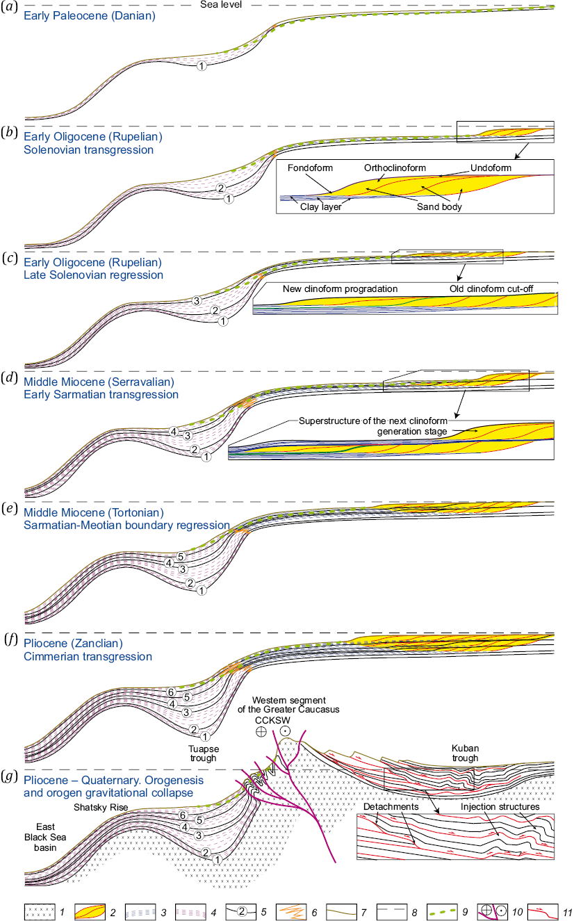
Fig. 23. Conceptual paleoprofiles, intersecting the western segment of the Greater Caucasus in the near-meridional direction and illustrating the selected episodes of the Cenozoic paleogeographic/tectonic evolution of this region (vertical scale and sea level are conventional).
Blue font marked the time and paleogeographic/tectonic situation. 1 – Cimmerian, Hercynian and Cadomian complexes of the heterogeneous structural basement of the Greater Caucasus orogen; 2 – sandy bodies of the orthoclinoform and clinoform complexes; 3 – clayey formations of the foundation-shaped parts of clinoform complexes and the parts of sedimentary basin, remote from the clinoform front; 4 – flysch formations formed in the zone of transition from the shelf areas of the Eastern Paratethys to the Eastern Black Sea Basin; 5 – stratigraphic boundaries corresponding to the heterogeneous bottom formations (circled numbers): 1 – Danian; 2 – Lower Solenovian transgressive; 3 – Upper Solenovian regressive; 4 – Middle Sarmatian transgressive; 5 – Upper Sarmatian-Meotian regressive; 6 – Cimmerian transgressive); 6 – facies transition between clayey (symbol 3) and flysch (symbol 4) formations; 7 – (paleo)topographic surface; 8 – sea level; 9 – projection of erosive thalweg incisions (clastic sediment transport channels); 10 – system of faults of the Caucasian segment of the Crimea-Caucasus-Kopetdagh transpressional shear zone with a large-amplitude right-lateral displacement; 11 – tectonogravitational detachments and displacement directions thereon.
Both authors made an equivalent contribution to this article, read and approved the final manuscript.
The authors declare that they have no conflicts of interest relevant to this manuscript.
1. Maikop – the Maikop Formation, in the present state of knowledge, stratigraphically covers the Rupelian and the Chattian stages of the Oligocene, as well as the and the Aquitatian and the Burdigalian stages of the Lower Miocene, and has an age of ~34–16 Ma; the Chokrak Formation covers the Chokrakian Regional Stage of the Eastern Paratethys (Langhinian Stage of the International Chronostratigraphic Chart and General Stratigraphic Scale of Russia) and has an age of ~15.5–14.0 Ma.
2. The modern view is that the lower Apsheronian time limit is about 2 Ma [Tesakov, 2021], and the Khavynian time range is 46.0–12.5 Ka [Makshaev, Tkach, 2023].
1. Adamia Sh., Zakariadze G., Chkhotua T., Sadradze N., Tsereteli N., Chabukiani A., Gventsadze A., 2011. Geology of the Caucasus: A Review. Turkish Journal of Earth Sciences 20 (5), 489–544. https://doi.org/10.3906/yer-1005-11.
2. Adamiya Sh.A., Gabuniya G.L., Kuteliya Z.A., Khutsishvili O.D., Tsimakuridze G.K., 1989. Basic Tectonic Features of the Caucasus. In: A.A. Belov, M.A. Satian (Eds), Geodynamics in the Caucasus. Nauka, Moscow, p. 3‒15 (in Russian)
3. Afanasenkov A.P., Nikishin A.M., Obukhov A.N., 2007. Geological Structure and Hydrocarbon Potential of the East Black Sea Region. Nauchny Mir, Moscow, 172 p. (in Russian) [Афанасенков А.П., Никишин А.М., Обухов А.Н. Геологическое строение и углеводородный потенциал Восточно-Черноморского региона. М.: Научный мир, 2007. 172 с.].
4. Akbayrama K., Okay A.I., Satir M., 2013. Early Cretaceous Closure of the Intra-Pontide Ocean in Western Pontides (Northwestern Turkey). Journal of Geodynamics 65, 38–55. https://doi.org/10.1016/j.jog.2012.05.003.
5. Akyol N., Zhu L., Mitchell B.J., Sözbilir H., Kekovalı K., 2006. Crustal Structure and Local Seismicity in Western Anatolia. Geophysical Journal International 166 (3), 1259–1269. https://doi.org/10.1111/j.1365-246X.2006.03053.x.
6. Al-Lazki A.I., Sandvol E., Seber D., Barazangi M., Turkelli N., Mohamad R., 2004. Pn Tomographic Imaging of Mantle Lid Velocity and Anisotropy at the Junction of the Arabian, Eurasian, and African Plates. Geophysical Journal International 158 (3), 1024–1040. https://doi.org/10.1111/j.1365-246X.2004.02355.x.
7. Almendinger O.A., Mityukov A.V., Myasoedov N.K., Nikishin A.M., 2011. Modern Erosion and Sedimentation Processes in the Deep-Water Part of the Tuapse Trough Based on the Data of 3D Seismic Survey. Doklady Earth Sciences 439, 899–901. https://doi.org/10.1134/S1028334X11070014.
8. Andrusov N.I., 1896. Neogene Deposits of the South Russia. Part One. Old Miocene. In: Proceedings of the Saint Petersburg Mineralogical Society 34, 195–245 (in Russian)
9. Arkhangelsky A.D., 1923. Introduction to the Study of Geology in the European Russia. Part 1: Tectonics and Development History of the Russian Platform. Gosgeoltechizdat, Moscow, 146 p. (in Russian)
10. Arkhangelsky A.D., 1927. Oil Formation Conditions in the North Caucasus. Soviet Oil Industry Publishing House, Moscow–Leningrad, 186 p. (in Russian)
11. Arkhangelsky A.D., 1941. Geological Structure and Geological History of the USSR. Vol. 1. Geological Structure of the USSR and Its Relation to the Structure of the Rest of the Earth’s Surface. Gostoptekhizdat, Moscow–Leningrad, 376 p. (in Russian)
12. Arkhangelsky A.D., Shatsky N.S., 1933. A Tectonic Scheme for the USSR. Bulletin of Moscow Society of Naturalists. Geological Section 11 (4), 323–348 (in Russian)
13. Arkhangelsky A.D., Shatsky N.S., Menner V.V., Pavlovsky E.V., Kheraskov N.P. et al., 1937. A Brief Overview of the Geological Structure and Geological History of the USSR. Publishing House of the USSR Academy of Science, Moscow–Leningrad, 310 p. (in Russian)
14. Artyushkov E.V., 1998. Rapid Crustal Subsidence and Uplift Events in the Continents with Loss in the Lithospheric Layer Rigidity as a Consequence of the Mantle Plume Upwelling at the Base of the Lithosphere. Bulletin of the Section of Geology, Geophysics and Mining Sciences RAS 4 (6), 70–106 (in Russian)
15. Artyushkov E.V., 2010. Mechanism of Formation of Superdeep Sedimentary Basins: Lithospheric Stretching or Eclogitization? Russian Geology and Geophysics 51 (12), 1304–1313. https://doi.org/10.1016/j.rgg.2010.11.002.
16. Artyushkov E.V., 2012. Neotectonic Crustal Uplifts as a Consequence of Mantle Fluid Infiltration Into the Lithosphere. Russian Geology and Geophysics 53 (6), 566–582. https://doi.org/10.1016/j.rgg.2012.04.005.
17. Artyushkov E.V., Chekhovich P.A., 2023. The West Siberian Sedimentary Basin. An Origin Without Strong Crustal Stretching – The Superdeep Drilling Data Analysis. Doklady Earth Sciences 512, 1006–1013. https://doi.org/10.1134/S1028334X23601517.
18. Avdeenko A.S., Dubinina E.O., Nosova A.A., Goltzman Yu.V., Oleinikova T.I., 2008. Isotopic (Nd, Sr, and δ18O) Signatures of the Late Miocene High Sr-Ba Granitoids in the Mineral’nye Vody Area, Northern Caucasus: Evidence of the Protolith Nature. Doklady Earth Sciences 422, 1073–1077. https://doi.org/10.1134/S1028334X08070155.
19. Avdeev B., Niemi N.A., 2011. Rapid Pliocene Exhumation of the Central Greater Caucasus Constrained by Low-Temperature Thermochronometry. Tectonics 30 (2), 1–16. https://doi.org/10.1029/2010TC002808.
20. Avigad D., Abbo A., Gerdes A., 2016. Origin of the Eastern Mediterranean: Neotethys Rifting Along a Cryptic Cadomian Suture with Afro-Arabia. GSA Bulletin 128 (7–8), 1286–1296. https://doi.org/10.1130/B31370.1.
21. Avila-Salinas W., 1991. Petrologic and Tectonic Evolution of the Cenozoic Volcanism in Bolivian Western Andes. In: R.S. Harmon, C.W. Rapela (Eds), Andean Magmatism and Its Tectonic Setting. GSA Special Papers 265, 245–258. https://doi.org/10.1130/SPE265-p245.
22. Aygül M., Okay A.I., Oberhänsli R., Sudo M., 2016. Pre-Collisional Accretionary Growth of the Southern Laurasian Active Margin, Central Pontides, Turkey. Tectonophysics 671, 218–234. https://doi.org/10.1016/j.tecto.2016.01.010.
23. Babina E.O., Mordasova A.V., Stoupakova A.V., Titarenko I.A., Sautkin R.S., Voronin M.E., Velichko M.A., Makhnutina M.L., Kolesnikova T.O., Tsygankova A.A., 2022. Sedimentation of the Oligocene-Lower Miocene Clinoforms of the Maikop Formation in the Eastern and Central Pre-Caucasus Region as a Key Criteria for Reservoir Exploration. Georesources 24 (2), 192–208 (in Russian) https://doi.org/10.18599/grs.2022.2.18.
24. Bazhenov M.L., Burtman V.S., 1987. The Origin of the Structural Arc of the Lesser Caucasus. Doklady of the USSR Academy of Sciences 293 (2), 416–419 (in Russian)
25. Belousov V.V., 1940. Greater Caucasus. Geotectonics Research Experience. Part II. Upper Cretaceous and Tertiary. Gosgeolizdat, Moscow–Leningrad, 176 p. (in Russian)
26. Beluzhenko E.V., 2011. The Upper-Miocene and Eopleistocene Coarse Deposits of the Western and Central Fore-Caucasus. Stratigraphy and Geological Correlation 19, 545–562. https://doi.org/10.1134/S0869593811050029.
27. Bindeman I.N., Colón D.P., Wotzlaw J.-F., Stern R., Chiaradia M., Guillong M., 2021a. Young Silicic Magmatism of the Greater Caucasus, Russia, with Implication for Its Delamination Origin Based on Zircon Petrochronology and Thermomechanical Modeling. Journal of Volcanology and Geothermal Research 412, 107173. https://doi.org/10.1016/j.jvolgeores.2021.107173.
28. Bindeman I.N., Wotzlaw J.-F., Stern R.A., Chiaradia M., Guillong M., Colón D.P., 2021b. Geochronology and Geochemistry Data for the Elbrus, Tyrnyauz, and Chegem Magmatic Centers, Greater Caucasus, Russia. Data in Brief 35, 106896. https://doi.org/10.1016/j.dib.2021.106896.
29. Bogatikov O.A., Gurbanov A.G., Katov D.M., Melekestsev I.V., Puriga A.I., 1998. The Elbrus Caldera in the Northern Caucasus. Doklady Earth Sciences 363А (9), 1202–1204.
30. Bozkurt E., Winchester J.A., Satir M., Crowley Q.G., 2012. Triassic Collision Between the Sakarya and Istanbul Zones, and Remarks on the Existence of Intra-Pontide Ocean in NW Turkey. In: Abstracts of the EGU General Assembly (April 22–27, 2012, Vienna, Austria). EGU, p. 14368.
31. Çelik O.F., Marzoli A., Marschik R., Chiaradia M., Neubauer F., Öz I., 2011. Early–Middle Jurassic Intra-Oceanic Subduction in the Izmir-Ankara-Erzincan Ocean, Northern Turkey. Tectonophysics 509 (1–2), 120–134. https://doi.org/10.1016/j.tecto.2011.06.007.
32. Charnotsky S.I., Gubkin I.M., 1910. Oil Shirvan Area Exploration Report. Bulletin of the Geological Committee 29 (1), 1–36 (in Russian)
33. Chernyshev I.V., Bubnov S.N., Lebedev V.A., Gol’tsman Yu.V., Bairova E.D., Yakushev A.I., 2014. Two Stages of Explosive Volcanism of the Elbrus Area: Geochronology, Petrochemical and Isotopic-Geochemical Characteristics of Volcanic Rocks, and Their Role in the Neogene-Quaternary Evolution of the Greater Caucasus. Stratigraphy and Geological Correlation 22, 96–121. https://doi.org/10.1134/S086959381401002X.
34. Chernyshev I.V., Lebedev V.A., Bubnov S.N., Arakelyants M.M., Gol’tsman Yu.V., 2002. Isotopic Geochronology of Quaternary Volcanic Eruptions in the Greater Caucasus. Geochemistry International 40 (11), 1042–1055.
35. Chiu H.-Y., Chung S.-L., Zarrinkoub M.H., Mohammadi S.S., Khatib M.M., Iizuka Y., 2013. Zircon U-Pb Age Constraints from Iran on the Magmatic Evolution Related to Neotethyan Subduction and Zagros Orogeny. Lithos 162–163, 70–87. https://doi.org/10.1016/j.lithos.2013.01.006.
36. Cowgill E., Forte A.M., Niemi N., Avdeev B., Tye A., Trexler Ch., Javakhishvili Z., Elashvili M., Godoladze T., 2016. Relict Basin Closure and Crustal Shortening Budgets During Continental Collision: An Example from Caucasus Sediment Provenance. Tectonics 35 (12), 2918‒2947. https://doi.org/10.1002/2016TC004295.
37. Dantsova K.I., Kuznetsov N.B., Latysheva I.V., Novikova A.S., Romanyuk T.V., Fedyukin I.V., Antipov M.P., Patina I.S., Khafizov S.F., 2024. To the Problems of Tectonic Origin and Filling Mechanism of the Western-Kuban Trough. Oil Industry 10, 54–57 (in Russian) https://doi.org/10.24887/0028-2448-2024-10-54-57.
38. De Silva S., Zandt G., Trumble R.T., Viramonte J.G., Salas G., Jimenez N., 2006. Large Ignimbrite Eruptions and Volcano-Tectonic Depressions in the Central Andes: A Thermomechanical Perspective. In: C. Troise, G. De Natale, C.R.J. Kilburn (Eds), Mechanisms of Activity and Unrest at Large Calderas. Geological Society of London Special Publications 269, p. 47–63. https://doi.org/10.1144/GSL.SP.2006.269.01.04.
39. Dinu C., Wong H.K., Tambrea D., Matenco L., 2005. Stratigraphic and Structural Characteristics of the Romanian Black Sea Shelf. Tectonophysics 410 (1–4), 417–435. https://doi.org/10.1016/j.tecto.2005.04.012.
40. Dotduev S.I., 1986. On the Nappe Structure of the Greater Caucasus. Geotectonics 5, 94–106 (in Russian)
41. Drobyshev D.V., 1929. A Preliminary Report on the 1926–1927 Geological Survey of the Dagestan Sector of the Caucasus. Bulletin of the Geological Committee 48 (7), 921–962 (in Russian)
42. Ducea M.N., 2001. The California Arc: Thick Granitic Batholiths, Eclogitic Residues, Lithospheric-Scale Thrusting, and Magmatic Flare-Ups. GSA Today 11, 4–10. https://doi.org/10.1130/1052-5173(2001)011%3C0004:TCATGB%3E2.0.CO;2.
43. Ducea M.N., 2002. Constraints on the Bulk Composition and Root Foundering Rates of Continental Arcs: A California Arc Perspective. Journal of Geophysical Research: Solid Earth 107 (B11), 2304. https://doi.org/10.1029/2001JB000643.
44. Ducea M.N., Saleeby J.B., 1996. Buoyancy Sources for a Large, Unrooted Mountain Range, the Sierra Nevada, California: Evidence from Xenolith Thermobarometry. Journal of Geophysical Research: Solid Earth 101 (В4), 8229–8244. https://doi.org/10.1029/95JB03452.
45. Ducea M.N., Saleeby J.B., 1998. A Case for Delamination of the Deep Batholithic Crust Beneath the Sierra Nevada, California. International Geology Review 40 (1), 78–93. https://doi.org/10.1080/00206819809465199.
46. Elkins-Tanton L.T., Grove T.L., 2003. Evidence for Deep Melting of Hydrous Metasomatized Mantle: Pliocene High-Potassium Magmas from the Sierra Nevadas. Journal of Geophysical Research: Solid Earth 108, B7. https://doi.org/10.1029/2002JB002168.
47. Ershov A.V., Brunet M.F., Korotaev M.V., Nikishin A.M., Bolotov S.N., 1999. Late Cenozoic Burial History and Dynamics of the Northern Caucasus Molasse Basin: Implications for Foreland Basin Modelling. Tectonophysics 313 (1–2), 219–241. https://doi.org/10.1016/S0040-1951(99)00197-3.
48. Ershov A.V., Nikishin A.M., 2004. Recent Geodynamics of the Caucasus-Arabia-East Africa Region. Geotectonics 38 (2), 123–136.
49. Faccenna C., Bellier O., Martinod J., Piromallo C., Regard V., 2006. Slab Detachment Beneath Eastern Anatolia: A Possible Cause for the Formation of the North Anatolian Fault. Earth and Planetary Science Letters 242 (1–2), 85–97. https://doi.org/10.1016/j.epsl.2005.11.046.
50. Farmer G.L., Glazner A.F., Manley C.R., 2002. Did Lithospheric Delamination Trigger Late Cenozoic Potassic Volcanism in the Southern Sierra Nevada, California? GSA Bulletin 114 (6), 754–768. https://doi.org/10.1130/0016-7606(2002)114%3C0754:DLDTLC%3E2.0.CO;2.
51. Fliedner M.M., Klemperer S.L., Christensen N.I., 2000. Three-Dimensional Seismic Model of the Sierra Nevada Arc, California, and Its Implications for Crustal and Upper Mantle Composition. Journal of Geophysical Research: Solid Earth 105 (B5), 10899–10921. https://doi.org/10.1029/2000JB900029.
52. Gallhofer D., von Quadt A., Peytcheva I., Schmid S.M., Heinrich C.A., 2015. Tectonic, Magmatic, and Metallogenic Evolution of the Late Cretaceous Arc in the Carpathian-Balkan Orogen. Tectonics 34 (9), 1813–1836. https://doi.org/10.1002/2015TC003834.
53. Galoyan G., Rolland Y., Sosson M., Corsini M., Billo S., Verati Ch., Melkonyan R., 2009. Geology, Geochemistry and 40Ar/39Ar Dating of Sevan Ophiolites (Lesser Caucasus, Armenia): Evidence for Jurassic Back-Arc Opening and Hot Spot Event Between the South Armenian Block and Eurasia. Journal of Asian Earth Sciences 34 (2), 135–153. https://doi.org/10.1016/j.jseaes.2008.04.002.
54. Gamkrelidze I., Shengelia D., Chichinadze G., Lee Y.-H., Okrostsvaridze A., Beridze G., Vardanashvili K., 2020. U-Pb LA-ICP-MS Dating of Zoned Zircons from the Greater Caucasus Pre-Alpine Crystalline Basement: Evidence for Cadomian to Late Variscan Evolution. Geologica Carpathica 71 (3), 249–263. https://doi.org/10.31577/GeolCarp.71.3.4.
55. Garzione C.N., Molnar P., Libarkin J.C., MacFadden B.J., 2006. Rapid Late Miocene Rise of the Bolivian Altiplano: Evidence for Removal of Mantle Lithosphere. Earth and Planetary Science Letters 241 (3–4), 543–556. https://doi.org/10.1016/j.epsl.2005.11.026.
56. Gautier P., Brun J.-P., Moriceau R., Sokoutis D., Martinod J., Jolivet L., 1999. Timing, Kinematics and Cause of Aegean Extension: A Scenario Based on a Comparison with Simple Analogue Experiments. Tectonophysics 315 (1–4), 31–72. https://doi.org/10.1016/S0040-1951(99)00281-4.
57. Gazis C.A., Lanphere M., Taylor H.P., Gurbanov A., 1995. 40Ar/39Ar and 18O/16O Studies of the Chegem Ash-Flow Caldera and the Eldjurta Granite: Cooling of Two Pliocene Igneous Bodies in the Greater Caucasus Mountains, Russia. Earth and Planetary Science Letters 134 (3–4), 377–391. https://doi.org/10.1016/0012-821X(95)00141-X.
58. Gerasimov V.Yu., Uliyanov A.A., Snezhko V.A., Mosar J., Lavrishev V.A., Gazeev V.M., Gurbanov A.G., 2022. The Zircon Isotope Dating of the Jurassic Basalts from the Ghoithsk Volcanic Area of the Western Greater Caucasus (Russia). Moscow University Geology Bulletin 1, 35–41 (in Russian) https://doi.org/10.33623/0579-9406-2022-1-35-41.
59. Göncüoğlu M.C., Gürsu S., Tekin U.K., Köksal S., 2008. New Data on the Evolution of the Neotethyan Oceanic Branches in Turkey: Late Jurassic Ridge Spreading in the Intra-Pontide Branch. Ofioliti 33 (2), 153–164. DOI: 10.4454/ofioliti.v33i2.366.
60. Göncüoğlu M.C., Marroni M., Pandolfi L., Ellero A., Ottria G., Catanzariti R., Tekin U.K., Sayit K., 2014. The Arkot Dağ Mélange in Araç Area, Central Turkey: Evidence of Its Origin Within the Geodynamic Evolution of the Intra-Pontide Suture Zone. Journal of Asian Earth Sciences 85, 117–139. https://doi.org/10.1016/j.jseaes.2014.01.013.
61. Gorbatikov A.V., Rogozhin E.A., Stepanova M.Yu., Kharazova Yu.V., Andreeva N.V., Perederin F.V., Zaalishvili V.B., Mel’kov D.A., Dzeranov B.V., Dzeboev B.A., Gabaraev A.F., 2015. The Pattern of Deep Structure and Recent Tectonics of the Greater Caucasus in the Ossetian Sector from the Complex Geophysical Data. Izvestiya, Physics of the Solid Earth 51, 26–37. https://doi.org/10.1134/S1069351315010073.
62. Gorshkov G.P., 1947. Disjunctive Tectonics of the Kopet Dagh and the Law of Shearing Stress. Moscow University Bulletin 1, 103–115 (in Russian)
63. Graeber F.M., Asch G., 1999. Three-Dimensional Models of P Wave Velocity and P-to-S Velocity Ratio in the Southern Central Andes by Simultaneous Inversion of Local Earthquake Data. Journal of Geophysical Research: Solid Earth 104 (B9), 20237–20256. https://doi.org/10.1029/1999JB900037.
64. Grün R., Tani A., Gurbanov A., Koshchug D., Williams I., Braun J., 1999. A New Method for the Estimation of Cooling and Denudation Rates Using Paramagnetic Centers in Quartz: A Case Study on the Eldzhurtinskiy Granite, Caucasus. Journal of Geophysical Research: Solid Earth 104 (В8), 17531–17549. https://doi.org/10.1029/1999JB900173.
65. Gubkin I.M., 1912. Maikop Oil Field. Oil Shirvan Area. Printing House of М.M. Stasyulevich, Saint Petersburg, 169 p. (in Russian)
66. Gubkin I.M., 1913. On the Question of the Geological Structure of the Middle Part of the Oil Shirvan Area. Printing House of М.M. Stasyulevich, Saint Petersburg, 95 p. (in Russian)
67. Gurbanov A.G., Bogatikov O.A., Melekestsev I.V., Lipman P.W., Lowenstern J.B., Miller D.R., Dokuchaev A.Ya., 2004. The Elbrus Caldera in the Northern Caucasus: Geological Structure and Time of Formation. Russian Journal of Earth Sciences 6 (4), 251–255. https://doi.org/10.2205/2004ES000161.
68. Heit B.S., 2005. Teleseismic Tomographic Images of the Central Andes at 21° S and 25.5° S: An Inside Look at the Altiplano and Puna Plateaus. PhD Thesis. Potsdam, 137 p. https://doi.org/10.2312/GFZ.b103-06052.
69. Hess J.C., Lippolt H.J., Gurbanov A.G., Michalski I., 1993. The Cooling History of the Late Pliocene Eldzhurtinskiy Granite (Caucasus, Russia) and the Thermochronological Potential of Grain Size/Age Relationships. Earth and Planetary Science Letters 117 (3–4), 393–406. https://doi.org/10.1016/0012-821X(93)90092-N.
70. Hippolyte J.-C., Müller C., Kaymakcı N., Sangu E., 2010. Dating of the Black Sea Basin: New Nannoplankton Ages from Its Inverted Margin in the Central Pontides (Turkey). In: M. Sosson, N. Kaymakc, R.A. Stephenson, F. Bergerat, V. Starostenko (Eds), Sedimentary Basin Tectonics from the Black Sea and Caucasus to the Arabian Platform. Geological Society of London Special Publications 340, 113–136. https://doi.org/10.1144/SP340.7.
71. Hippolyte J.-C., Murovskaya A., Volfman Y., Yegorova T., Gintov O., Kaymakci N., Sanguet E., 2018. Age and Geodynamic Evolution of the Black Sea Basin: Tectonic Evidences of Rifting in Crimea. Marine and Petroleum Geology 93, 298–314. https://doi.org/10.1016/j.marpetgeo.2018.03.009.
72. Ismail-Zadeh A., Adamia S., Chabukiani A., Chelidze T., Cloetingh S., Floyd M., Gorshkov A., Gvishiani A. et al., 2020. Geodynamics, Seismicity, and Seismic Hazards of the Caucasus. Earth-Science Reviews 207, 103222. https://doi.org/10.1016/j.earscirev.2020.103222.
73. Jolivet L., 2001. A Comparison of Geodetic and Finite Strain Pattern in the Aegean, Geodynamic Implications. Earth and Planetary Science Letters 187 (1–2), 95–104. https://doi.org/10.1016/S0012-821X(01)00277-1.
74. Jolivet L., Faccenna C., 2000. Mediterranean Extension and the Africa-Eurasia Collision. Tectonics 19 (6), 1095–1106. https://doi.org/10.1029/2000TC900018.
75. Jones C.H., Farmer G.L., Unruh J., 2004. Tectonics of Pliocene Delamination of Lithosphere of the Sierra Nevada, California. GSA Bulletin 116 (11–12), 1408–1422. https://doi.org/10.1130/B25397.1.
76. Jones C.H., Kanamori K., Roeker S.W., 1994. Missing Roots and Mantle "Drips": Regional Pn and Teleseismic Arrival Times in the Southern Sierra Nevada and Vicinity, California. Journal of Geophysical Research: Solid Earth 99 (В3), 4567–4601. https://doi.org/10.1029/93JB01232.
77. Kahle H.-G., Cocard M., Peter Y., Geiger A., Reilinger R., McClusky S., King R., Barka A., Veis G., 1999. The GPS Strain Rate Field in the Aegean Sea and Western Anatolia. Geophysical Research Letter 26 (16), 2513–2516. https://doi.org/10.1029/1999GL900403.
78. Kaigorodova E.N., Lebedev V.A., 2021. The Mesozoic Magmatic Complexes on the Northern Slope of the Greater Caucasus. In: I.A. Kerimov, V.A. Shirokova, V.B. Zaalishvili, V.I. Cherkashin (Eds), The Modern Problems of Geology, Geophysics and Geoecology of the North Caucasus. Collective Monograph on the Basis of the Materials of the XI All-Russian Scientific and Technical Conference with International Participation (November 18–20, 2021, Essentuki). Vol. XI. Moscow, p. 69–73 (in Russian) DOI:10.34708/GSTOU.2021.21.99.012.
79. Kaigorodova E.N., Lebedev V.A., 2022. The Age, Petrological-Geochemical Characteristics, and Origin of Igneous Rocks of the Middle Jurassic Khulam Volcano-Plutonic Complex, North Caucasus. Journal of Volcanology and Seismology 16, 116–142. https://doi.org/10.1134/S0742046322020038.
80. Kaigorodova E.N., Lebedev V.A., Chernyshev I.V., Yakushev A.I., 2021. Neogene–Quaternary Magmatism in Eastern Balkaria (North Caucasus, Russia): Evidence from the Isotope-Geochronological Data. Doklady Earth Sciences 496, 37–44. https://doi.org/10.1134/S1028334X21010098.
81. Kalafat D., 2017. Seismicity and Tectonics of the Black Sea. International Journal of Earth Science and Geophysics 3 (1), 1–8. DOI:10.35840/2631-5033/1811.
82. Kalugin P.I., 1946. On Diagonal Ruptures of the Central Kopet Dagh. Soviet Geology 11, 54–62 (in Russian) [Калугин П.И. О диагональных разрывах Центрального Копетдага // Советская геология. 1946. Вып. 11. С. 54–62].
83. Kamzolkin V.A., Latyshev A.V., Vidyapin Y.P., Somin M.L., Smul’skaya A.I., Ivanov S.D., 2018. Late Vendian Complexes in the Structure of Metamorphic Basement of the Fore Range Zone, Greater Caucasus. Geotectonics 52, 331–345. https://doi.org/10.1134/S0016852118030020.
84. Kay R.W., Kay S.M., 1993. Delamination and Delamination Magmatism. Tectonophysics 219 (1–3), 177–189. https://doi.org/10.1016/0040-1951(93)90295-U.
85. Kay S.M., Corira B., Viramonte J., 1994. Young Mafic Back Arc Volcanics as Indicator of Continental Lithospheric Delamination Beneath the Argentine Puna Plateau, Central Andes. Journal of Geophysical Research: Solid Earth 99 (B12), 24323–24339. https://doi.org/10.1029/94JB00896.
86. Kerimov V.Yu., Yandarbiev N.Sh., Mustaev R.N., Kudryashov A.A., 2021. Hydrocarbon Systems of the Crimean-Caucasian Segment of the Alpine Folded System. Georesources 23 (4), 21–33 (in Russian) https://doi.org/10.18599/grs.2021.4.3.
87. Keskin M., 2003. Magma Generation by Slab Steepening and Breakoff Beneath a Subduction-Accretion Complex: An Alternative Model for Collision-Related Volcanism in Eastern Anatolia, Turkey. Geophysical Research Letter 30 (24), 8046. https://doi.org/10.1029/2003GL018019.
88. Keskin M., 2007. Eastern Anatolia: A Hot Spot in a Collision Zone Without a Mantle Plume. In: G.R. Foulger, D.M. Jurdy (Eds), Plates, Plumes, and Planetary Processes. GSA, 693–722. https://doi.org/10.1130/2007.2430(32).
89. Khain V.E., 1984. Regional Geotectonics. Mediterranean Alpine Belt. Nedra, Moscow, 344 p. (in Russian)
90. Khain V.E., Leonov Yu.G., Leonov M.G. (Eds), 1998. International Tectonic Map of Europe. Scale 1:5000000. VSEGEI, Saint Petersburg, 6 sheet (in Russian)
91. Kholodov V.N., Nedumov R.I., 1981. Lithology and Geochemistry of the Middle Miocene of the Eastern Cis-Caucasia. Nauka, Moscow, 208 p. (in Russian)
92. Kiselev A.I., Ivanov A.V., Danilov B.S., 2015. Compositional and Thermal Differences Between Lithospheric and Asthenospheric Mantle and Their Influence on Continental Delamination. Geodynamics & Tectonophysics 6 (2), 255–265 (in Russian) https://doi.org/10.5800/GT-2015-6-2-0180.
93. Klavdieva N.V., 2007. Cenozoic Tectonic Subsidence of the Ciscaucasian Marginal Troughs. Brief PhD Thesis (Candidate of Geology and Mineralogy). Moscow, 24 p. (in Russian)
94. Kolodyazhny S.Yu., Kuznetsov N.B., Makhinya E.I., Shalaeva E.A., Dantsova K.I., Romanyuk T.V., Antipov M.P., Khafizov S.F., Parfenov G.E., 2024a. Tectono-Gravitational Detachments of the Southern Border of the Western Preсaucasus Basin on the Basis of Seismostratigraphic Analysis. Oil Industry 5, 54–61 (in Russian) https://doi.org/10.24887/0028-2448-2024-5-54-61.
95. Kolodyazhny S.Yu., Kuznetsov N.B., Makhinya E.I., Shalaeva E.A., Dantsova K.I., Romanyuk T.V., Antipov M.P., Parfenov G.E., 2024b. Tectono-Gravitational Detachments in the Alpine Cover of the Northern Slope of the Greater Caucasus and Western Pre-Caucasus Basin (Adygean Segment). Geotectonics 58, 611–638. https://doi.org/10.1134/S0016852124700407.
96. Kolodyazhny S.Yu., Kuznetsov N.B., Shalaeva E.A., Makhinya E.I., Dantsova K.I., Romanyuk T.V., Antipov M.P., Khafizov S.F., Parfenov G.E., 2024c. Structure of the Western Segments of the Greater Caucasus and Adjacent Precaucasus Basin in the Light of New Ideas on the Time of Origin of the Mountain Belt. Oil Industry 5, 42–47 (in Russian) https://doi.org/10.24887/0028-2448-2024-5-42-47.
97. Kopp M.L., 1997. Structures of Lateral Extrusion in the Alpine-Himalayan Collisional Belt. Nauchny Mir, Moscow, 314 p. (in Russian)
98. Kopp M.L., 2004. Mobilistic Neotectonics of the Platforms of the Southeastern Europe. Nauka, Moscow, 340 p. (in Russian)
99. Kopp M.L., Kurdin N.N., 1980. Regional Shears in the Southeast Caucasus. Proceedings of Higher Educational Establishments. Geology and Exploration 11, 30–37 (in Russian)
100. Koronovsky H., Demina L., 2007. Disappeared Pliocene Volcanoes of the Main Caucasian Range and Grandiose Explosion of the Kazbegi at the Beginning of Pleistocene (North Caucasus). In: Problems of Geodynamics, Petrography and Metallogeny of the Caucasus. Proceedings of the Scientific Sessions Dedicated to the 100th Anniversary of the Birth of Academician Sh.A. Azizbekov. Nafta-Press, Baku, p. 92–103 (in Russian)
101. Koronovsky N.V., Molyavko V.G., Ostafiychuk N.M., Gasanov Yu.L., 1987. Evolution and Genesis of the Pliocene-Quaternary Volcanites in the Upper Chegem Highlands (North Caucasus). In: Geology and Mineral Resources of the Greater Caucasus. Nauka, Moscow, p. 114–133 (in Russian)
102. Kostitsyn Y.A., Kremenetsky A.A., 1995. Age of Final Magmatic Stage of the Eldjurtu Granite: Rb-Sr Isochron Dating of Aplites. Geokhimiya 7, 925–932 (in Russian)
103. Kostitsyn Yu.A., 1995. Conditions of the Eldjurta Granite Formation According to Isotope Data (Oxygen and Strontium) in Vertical Profile. Geochemistry International 27, 780–797 (in Russian)
104. Koulakov I., Zabelina I., Amanatashvili I., Meskhia V., 2012. Nature of Orogenesis and Volcanism in the Caucasus Region Based on Results of Regional Tomography. Solid Earth 3 (2), 327–337. https://doi.org/10.5194/se-3-327-2012.
105. Kripinevich V.L., Mikhailenko R.S., Korneev V.I., Kondratyev I.A., 1989. New Data on the Geological Structure and Oil-and-Gas Potential of the Western Ciscaucasia. Russian Oil and Gas Geology 8, 2–8 (in Russian)
106. Kuznetsov N.B., 2009. Cambrian Сollision of Baltica and Arctica – The Initial Stage of "Assembly" of the Northern Part of the Late Palaeozoic – Early Mesozoic Pangea. Bulletin of Moscow Society of Naturalists. Geological Series 84 (1), 18–38 (in Russian)
107. Kuznetsov N.B., Latysheva I.V., Novikova A.S., Dubenskiy A.S., Erofeeva K.G., Sheshukov V.S., Dantsova K.I., Khafizov S.F., Romanyuk T.V., Fedyukin I.V., 2024a. To the Question of the Tectonic Type of the Western-Kuban Trough and the Time of Uplift of the Western Segment of the Greater Caucasus Orogeny. Oil Industry 10, 58–63 (in Russian) DOI:10.24887/0028-2448-2024-10-58-63.
108. Kuznetsov N.B., Natapov L.M., Belousova E.A., O`Reilly S.Y., Griffin W.L., 2010. Geochronological, Geochemical and Isotopic Study of Detrital Zircon Suites from Late Neoproterozoic Clastic Strata Along the NE Margin of the East European Craton: Implications for Plate Tectonic Models. Gondwana Research 17 (2–3), 583–601. https://doi.org/10.1016/j.gr.2009.08.005.
109. Kuznetsov N.B., Razumovsky A.A., Latysheva I.V., Shatsillo A.V., Fedyukin I.V., Dantsova K.I., Romanyuk T.V., Maslova O.A. et al., 2025. The Age of the Urlesh Formation (Basal Level of the Paleozoic Succession of the Northern Slope of the Greater Caucasus) and the Sources of Its Clastic Material. Doklady Earth Sciences 521, 1. https://doi.org/10.1134/S1028334X24604309.
110. Kuzntsov N.B., Romanyuk T.V., 2021. Peri-Gondwanan Blocks in the Structure of the Southern and Southeastern Framing of the East European Platform. Geotectonics 55, 439–472. https://doi.org/10.1134/S0016852121040105.
111. Kuznetsov N.B., Romanyuk T.V., Dantsova K.I., Fedyukin I.V., Latysheva I.V., Shatsillo A.V., Maslova O.A., Polina S.D., 2023. On the Tectonic Nature of the Western Kuban Trough. Oil Industry 9, 78–84 (in Russian) https://doi.org/10.24887/0028-2448-2023-9-78-84.
112. Kuznetsov N.B., Romanyuk T.V., Dantsova K.I., Polina S.D., Fedyukin I.V., Latysheva I.V., Shatsillo A.V., Maslova O.A., 2024b. Characteristics of Sedimentary Strata of the Indolo-Kuban Trough as Indicated by the Results of U-Pb Isotopic Dating of Detrital Zircons. Interior of Povolzhye and Pricaspian Region 113, 4–15 (in Russian) https://doi.org/10.24412/1997-8316-2024-113-4-15
113. Kuznetsov N.B., Romanyuk T.V., Strashko A.A., Novikova A.S., 2022. Ophiolite Association of Cape Fiolent (Western Part of the Mountainous Crimea) – the Upper Age Constraint According to the U-Pb Isotope Dating of Plagiorhyolites (Monakh Cliff). Journal of Mining Institute 255, 435–447 (in Russian) https://doi.org/10.31897/PMI.2022.37.
114. Le Pichon X., Angelier J., 1979. The Hellenic Arc and Trench System: A Key to the Neotectonic Evolution of the Eastern Mediterranean Area. Tectonophysics 60 (1–2), 1–42. https://doi.org/10.1016/0040-1951(79)90131-8.
115. Le Pichon X., Chamot-Rooke N., Lallemant S., Noomen R., Veis G., 1995. Geodetic Determination of the Kinematics of Central Greece with Respect to Europe: Implications for Eastern Mediterranean Tectonics. Journal of Geophysical Research: Solid Earth 100 (В7), 12675–12690. https://doi.org/10.1029/95JB00317.
116. Lebedev V.A., Bubnov S.N., Chernyshev I.V., Gol’tsman Yu.V., 2006. Basic Magmatism in the Geological History of the Elbrus Neovolcanic Area, Greater Caucasus: Evidence from K-Ar and Sr-Nd Isotope Data. Doklady Earth Sciences 406, 37–40. https://doi.org/10.1134/S1028334X06010107.
117. Lebedev V.A., Bubnov S.N., Yakushev A.I., 2011a. Magmatic Activity Within the Northern Caucasus in the Early Neopleistocene: Active Volcanoes of the Elbrus Center, Chronology, and Character of Eruptions. Doklady Earth Sciences 436, 32–38. https://doi.org/10.1134/S1028334X11010065.
118. Lebedev V.A., Chernyshev I.V., Bubnov S.N., Medvedeva E.S., 2005. Chronology of Magmatic Activity of the Elbrus Volcano (Greater Caucasus): Evidence from K-Ar Isotope Dating of Lavas. Doklady Earth Sciences 405A (9), 1321–1326.
119. Lebedev V.A., Chernyshev I.V., Chugaev A.V., Arakelyants M.M., 2004. Duration of Young (Pliocene) Intrusive Magmatism in the Tyrnyauz Ore Field, Northern Caucasus: New K-Ar and Rb-Sr Data. Doklady Earth Sciences 396 (4), 529–533.
120. Lebedev V.A., Chernyshev I.V., Chugaev A.V., Gol’tsman Yu.V., Bairova E.D., 2010а. Geochronology of Eruptions and Parental Magma Sources of Elbrus Volcano, the Greater Caucasus: K-Ar and Sr-Nd-Pb Isotope Data. Geochemistry International 48, 41–67. https://doi.org/10.1134/S0016702910010039.
121. Lebedev V.A., Chernyshev I.V., Yakushev A.I., 2011b. Initial Time and Duration of Quaternary Magmatism in the Aragats Neovolcanic Area (Lesser Caucasus, Armenia). Doklady Earth Sciences 437, 532–536. https://doi.org/10.1134/S1028334X11040209.
122. Lebedev V.A., Sakhno V.G., Yakushev A.I., 2010b. Total Duration and Spatial Migration of Quaternary Volcanism in the El’brus Region, Greater Caucasus. Doklady Earth Sciences 430, 80–85. https://doi.org/10.1134/S1028334X10010186.
123. Lebedev V.A., Vashakidze G.T., 2014. The Catalogue of Quaternary Volcanoes of the Greater Caucasus Based on Geochronological, Volcanological and Isotope-Geochemical Data. Journal of Volcanology and Seismology 8, 93–107. https://doi.org/10.1134/S0742046314020043.
124. Lee C.-T., Rudnick R.L., Brimhall G., 2001. Deep Lithospheric Dynamics Beneath the Sierra Nevada During the Mesozoic and Cenozoic as Inferred from Xenolith Petrology. Geochemistry, Geophysics, Geosystems 2, 12. https://doi.org/10.1029/2001GC000152.
125. Lee C.-T.A., Cheng X., Horodyskyj U., 2006. The Development and Refinement of Continental Arcs by Primary Basaltic Magmatism, Garnet Pyroxenite Accumulation, Basaltic Recharge and Delamination: Insights from the Sierra Nevada, California. Contributions to Mineralogy and Petrology 151, 222–242. https://doi.org/10.1007/s00410-005-0056-1.
126. Lei J., Zhao D., 2007. Teleseismic Evidence for a Break-off Subducting Slab Under Eastern Turkey. Earth and Planetary Science Letters 257 (1–2), 14–28. https://doi.org/10.1016/j.epsl.2007.02.011.
127. Leonov Yu.G. (Ed.)., 2007. Greater Caucasus in the Alpine Epoch. GEOS, Moscow, 368 p. (in Russian)
128. Leonov Yu.G., Gushchenko O.I., Kopp M.L., Rastsvetaev L.M., 2001. Relationship Between the Late Cenozoic Stresses and Deformations in the Caucasian Sector of the Alpine Belt and Its Northern Foreland. Geotectonics 35 (1), 30–50.
129. Lipman P.W., Bogatikov O.A., Tsvetkov A.A., Gazis C., Gurbanov A.G., Hon K., Koronovsky N.V., Kovalenko V.I., Marchev P., 1993. 2.8-Ma Ash-Flow Caldera at Chegem River in the Northern Caucasus Mountains (Russia), Contemporaneous Granites, and Associated Ore Deposits. Journal of Volcanology and Geothermal 57 (1–2), 85–124. https://doi.org/10.1016/0377-0273(93)90033-N.
130. Lukk A.A., Shevchenko V.I., 2019. Seismicity, Tectonics, and GPS Geodynamics of the Caucasus. Izvestiya, Physics of the Solid Earth 55, 626–648. https://doi.org/10.1134/S1069351319040062.
131. Makshaev R.R., Tkach N.T., 2023. Chronology of Khvalynian Stage of the Caspian Sea According to Radiocarbon Dating. Geomorfologiya i Paleogeografiya 54 (1), 37–54 (in Russian) https://doi.org/10.31857/S2949178923010103.
132. Manley C.R., Glazner A.F., Farmer G.L., 2000. Timing of Volcanism in the Sierra Nevada of California: Evidence for Pliocene Delamination of the Batholithic Root? Geology 28 (9), 811–814. https://doi.org/10.1130/0091-7613(2000)28%3C811:TOVITS%3E2.0.CO;2.
133. Marinin A.V., Kopaevich L.F., Stupin S.I., 2011. Geological Structure of the Ubinka River Region (NW Caucasus). Moscow University Geology Bulletin 5, 33–41 (in Russian)
134. McClusky S., Balassanian S., Barka A., Demir C., Ergintav S., Georgiev L., Gurkan O., Hamburger M. et al., 2000. Global Positioning System Constraints on Plate Kinematics and Dynamics in the Eastern Mediterranean and Caucasus. Journal of Geophysical Research: Solid Earth 105 (В3), 5695–5719. https://doi.org/10.1029/1999JB900351.
135. Meinhold G., Morton A.C., Avigad D., 2013. New Insights Into Peri-Gondwana Paleogeography and the Gondwana Super-Fan System from Detrital Zircon U-Pb Ages. Gondwana Research 23 (2), 661–665. https://doi.org/10.1016/j.gr.2012.05.003.
136. Meliksetyan Kh.B., 2012. Geochemistry of Volcanic Series of Aragats Province. Proceedings of NAS RA. Earth Sciences 65 (3), 34–59 (in Russian)
137. Milanovsky E.E., 1968. Neotectonics of the Caucasus. Nedra, Moscow, 484 p. (in Russian)
138. Milanovsky E.E., Khain V.E., 1963. Outlines on the Regional Geology of the USSR. Geological Structure of the Caucasus. MSU Publishing House, Moscow, 378 p. (in Russian)
139. Milanovsky E.E., Koronovsky N.V., 1973. Orogenic Volcanism and Tectonics of the Alpine Belt of Eurasia. Nedra, Moscow, 280 p. (in Russian)
140. Milyukov V.K., Mironov A.P., Ovsyuchenko A.N., Gorbatikov A.V., Steblov G.M., Korzhenkov A.M., Agibalov A.O., Sentsov A.A. et al., 2022. Contemporary Tectonic Movements of the Western Caucasus and the Ciscaucasia Based on Satellite-Geodetic Observations. Geotectonics 56, 41–54. https://doi.org/10.1134/S0016852122010058.
141. Milyukov V.K., Mironov A.P., Rogozhin E.A., Steblov G.M., 2015. Velocities of Contemporary Movements of the Northern Caucasus Estimated from GPS Observations. Geotectonics 49 (3), 210–218. https://doi.org/10.1134/S0016852115030036.
142. Moghadam H.S., Li X.-H., Griffin W.L., Stern R.J., Thomsen T.B., Meinhold G., Aharipour R., O’Reilly S.Y., 2017. Early Paleozoic Tectonic Reconstruction of Iran: Tales from Detrital Zircon Geochronology. Lithos 268–271, 87‒101. https://doi.org/10.1016/j.lithos.2016.09.008.
143. Morozova E.B., Sergeev S.A., Savelev A.D., 2017. Cretaceous and Jurassic Intrusions in Crimean Mountains: The First Data of U-Pb (SIMS SHRIMP) Dating. Doklady Earth Sciences 474, 530–534. https://doi.org/10.1134/S1028334X17050075.
144. Mossar J., Mauvilly J., Koiava K., Gamkrelidze I., Enna N., Lavrishev V., Kalberguenova V., 2022. Tectonics in the Greater Caucasus (Georgia – Russia): From an Intracontinental Rifted Basin to a Doubly Verging Fold-and-Thrust Belt. Marine and Petroleum Geology 140, 105630. https://doi.org/10.1016/j.marpetgeo.2022.105630.
145. Mumladze T., Forte A.M., Cowgill E.S., Trexler C.C., Niemi N.A., Yıkılmaz M.B., Kellogg L.H., 2015. Subducted, Detached, and Torn Slabs Beneath the Greater Caucasus. GeoResJ 5, 36–46. https://doi.org/10.1016/j.grj.2014.09.004.
146. Munteanu I., Matenco L., Iusco G., Dinu C., Cloeting S., 2014. Tectonics of the Western Black Sea Back-Arc Basin as Reveled by the Architecture of Its Sedimentary Fill. In: New Developments in the Investigation of Conventional and Unconventional Petroleum Systems in European Basins. Abstracts of the European Regional Conference and Exhibition (May 13–15, 2014, Barcelona, Spain). AAPG, p. 21.
147. Muratov M.V., 1955. Tectonic Structure and History of the Plains Separating the Russian Platform from the Crimea and Caucasus. Soviet Geology 48, 36–66 (in Russian)
148. Muratov M.V., 1967. Tectonic Dissection of the Territory of the Soviet Union and Main Structural Features of the Foldbelts Therein. Proceedings of Higher Educational Establishments. Geology and Exploration 10, 17–63 (in Russian)
149. Muratov M.V., 1972. Principal Types of Basins of Ancient Platforms and the Problem of Their Origin. Bulletin of Moscow Society of Naturalists. Geological Section 47 (5), 61–71 (in Russian)
150. Natalin B., Sunal G., Satir M., Toraman E., 2012. Tectonics of the Strandja Massif, NW Turkey: History of a Long-Lived Arc at the Northern Margin of Palaeo-Tethys. Turkish Journal of Earth Sciences 21 (5), 755–798. https://doi.org/10.3906/yer-1006-29.
151. Nikishin A.M., Ershov A.V., Nikishin V.A., 2010. Geological History of Western Caucasus and Adjacent Foredeeps Based on Analysis of the Regional Balanced Section. Doklady Earth Sciences 430, 155–157. https://doi.org/10.1134/S1028334X10020017.
152. Nikishin A.M., Okay A., Tuysuz O., Demirer A., Wannier M., Amelin N., Petrov E., 2015а. The Black Sea Basins Structure and History: New Model Based on New Deep Penetration Regional Seismic Data. Part 1: Basins Structure. Marine and Petroleum Geology 59, 638–655. https://doi.org/10.1016/j.marpetgeo.2014.08.017.
153. Nikishin A.M., Okay A., Tuysuz O., Demirer A., Wannier M., Amelin N., Petrov E., 2015b. The Black Sea Basins Structure and History: New Model Based on New Deep Penetration Regional Seismic Data. Part 2: Tectonic History and Paleogeography. Marine and Petroleum Geology 59, 656–670. https://doi.org/10.1016/j.marpetgeo.2014.08.018.
154. Nikishin A.M., Wannier M., Alekseev A.S., Almendinger O.A., Fokin P.A., Gabdullin R.R., Khudoley A.K., Kopaevich L.F., Mityukov A.V., Petrov E.I., Rubsova E.V., 2015с. Mesozoic to Recent Geological History of Southern Crimea and the Eastern Black Sea Region. In: M. Sosson, R.A. Stephenson, S.A. Adamia (Eds), Tectonic Evolution of the Eastern Black Sea and Caucasus. Geological Society of London Special Publications 428 (1), 241–264. https://doi.org/10.1144/SP428.1.
155. Okay A.I., Nikishin A.M., 2015. Tectonic Evolution of the Southern Margin of Laurasia in the Black Sea Region. International Geology Review 57 (5–8), 1051–1076. https://doi.org/10.1080/00206814.2015.1010609.
156. Okay A.I., Sunal G., Sherlock S., Altiner D., Tüysüz O., Kylander-Clark A.R.C., Aygül M., 2013. Early Cretaceous Sedimentation and Orogeny on the Active Margin of Eurasia: Southern Central Pontides, Turkey. Tectonics 32 (5), 1247–1271. https://doi.org/10.1002/tect.20077.
157. Okay A.I., Tanzel I., Tüysüz O., 2001. Obduction, Subduction and Collision as Reflected in the Upper Cretaceous–Lower Eocene Sedimentary Record of Western Turkey. Geological Magazine 138 (2), 117–142. https://doi.org/10.1017/S0016756801005088.
158. Okay A.I., Zattin M., Cavazza W., 2010. Apatite Fission-Track Data for the Miocene Arabia-Eurasia Collision. Geology 38 (1), 35–38. https://doi.org/10.1130/G30234.1.
159. Özdamar Ş., Billor M.Z., Sunal G., Esenli F., Roden M.F., 2013. First U-Pb SHRIMP Zircon and 40Ar/39Ar Ages of Metarhyolites from the Afyon-Bolkardag Zone, SW Turkey: Implications for the Rifting and Closure of the Neo-Tethys. Gondwana Research 24 (1), 377–391. https://doi.org/10.1016/j.gr.2012.10.006.
160. Panov D.I., Lomize M.G., 2007. Early and Middle Jurassic of the Greater Caucasus (Stratigraphy and Tectonics, Volcanism and Geodynamic Evolution). In: Yu.G. Leonov (Ed.), The Greater Caucasus of the Alpine Epoch. GEOS, Moscow, p. 39–110 (in Russian)
161. Parfenov A.V., Lebedev V.A., Chernyshev I.V., Vashakidze G.T., Yakushev A.I., Goltsman Yu.V., Chugaev A.V., Oleinikova T.I., Kanunnikova E.M., Gabarashvili K.A., 2019. Petrological-Geochemical Characteristics of Lavas, Sources and Evolution of Magmatic Melts of the Kazbek Neovolcanic Center (Greater Caucasus). Petrology 27, 606–632. https://doi.org/10.1134/S0869591119060043.
162. Patina I.S., Fomina V.V., Tkacheva A.A., Kuznetsov N.B., 2024а. Seismostratigraphic Analysis in Paleogeographic Reconstructions of Isolated Basins: The Case of the Early Oligocene Solenovian Crisis in the Eastern Paratethys. Doklady Earth Sciences 519, 2217–2223. https://doi.org/10.1134/S1028334X2460350X.
163. Patina I.S., Gorkin G.M., Postnikova I.S., 2024b. Manifestations of the Early Oligocene Solenovian Crisis on the Northern Shelf of the Eastern Paratethys. Lithology and Mineral Resources 59, 381–389. https://doi.org/10.1134/S0024490224700615.
164. Patina I.S., Leonov Yu.G., Volozh Yu.A., Kopp M.L., Antipov M.P., 2017. Crimea–Kopet Dagh Zone of Concentrated Orogenic Deformations as a Transregional Late Collisional Right-Lateral Strike-Slip Fault. Geotectonics 51, 353–365. https://doi.org/10.1134/S0016852117040069.
165. Pavlenkova G.A., 2012. Crustal Structure of the Caucasus from the Stepnoe–Bakuriani and Volgograd–Nakhichevan DSS Profiles (Reinterpretation of the Primary Data). Izvestiya, Physics of the Solid Earth 48, 375–384. https://doi.org/10.1134/S1069351312040040.
166. Pavlenkova N.I., Yegorova T.P., Baranova E.P., Pavlenkova G.A., 2022. Deep Structure and Geodynamics of the Black Sea–Caspian Region. Geotectonics 56, 157–177. https://doi.org/10.1134/S0016852122020054.
167. Polina S.D., Dantsova K.I., Fayzullin G.I., 2023. Actual Problems and Issues of Tectonics, Geology and Oil and Gas Potential of the North-West Caucasus. Bulletin of Osh Technological University 2-1, 269–276 (in Russian)
168. Popkov V.I., 2006. Imbricate Thrust Structure of the Northwestern Caucasus. Doklady Earth Sciences 411, 1222–1224. https://doi.org/10.1134/S1028334X06080137.
169. Popkov V.I., 2010. Geodynamic Setting of the Structural Formation of Cenozoic Foredeeps in West Caucasus. Geology, Geography and Global Energy 3 (38), 23–27 (in Russian)
170. Popov S.V., Akhmetiev M.A., Lopatin A.V., Bugrova E.M., Sychevskaya E.K., Shcherba I.G., 2009. Paleogeography and Biogeography of the Paratethys Basins. Part 1. Late Eocene – Early Miocene. Nauchny Mir, Moscow, 178 p. (in Russian)
171. Popov S.V., Antipov M.P., Zastrozhnov A.S., Kurina E.E., Pinchuk T.N., 2010. Sea-Level Fluctuations on the Northern Shelf of the Eastern Paratethys in the Oligocene-Neogene. Stratigraphy and Geological Correlation 18, 200–224. https://doi.org/10.1134/S0869593810020073.
172. Popov S.V., Patina I.S., 2023. History of Paratethys. Priroda 6, 3–14 (in Russian) https://doi.org/10.7868/S0032874X23060017.
173. Postnikova I.S., Patina I.S., Gorkin G.M., 2024. Geological Setting and Formation of the Erosional Structure of Upper Miocene Deposits in Western Ciscaucasia. Lithology and Mineral Resources 59, 517–525. https://doi.org/10.1134/S0024490224700676.
174. Quinteros J., Ramos V.A., Jacovkis P.M., 2008. Constraints on Delamination from Numerical Models. In: Extended Abstracts of the 7th International Symposium on Andean Geodynamics (September 2–4, 2008). IRD, Paris, p. 417–420.
175. Rastsvetaev L.M., 1989. Shears and Alpine Dynamics of the Caucasus Region. In: A.A. Belov, M.A. Satian (Eds), Geodynamics of the Caucasus. Nauka, Moscow, p. 109–112 (in Russian)
176. Ritz J.-F., Avagyan A., Mkrtchyan M., Nazari H., Blard P.-H., Karakhanian A., Philip H., Balescu S. et al., 2016. Active Tectonics Within the NW and SE Extensions of the Pambak-Sevan-Syunik Fault: Implications for the Present Geodynamics of Armenia. Quaternary International 395, 61–78. https://doi.org/10.1016/j.quaint.2015.05.021.
177. Roban R.-D., Melinte M.C., 2005. Paleogene Litho- and Biostratigraphy of the NE Getic Depression (Romania). Acta Palaeontologica Romaniae 5, 423–439.
178. Rogozhin E.A., Gorbatikov A.V., Stepanova M.Y., Ovsyuchenko A.N., Andreeva N.V., Kharazova Y.V., 2015. The Structural Framework and Recent Geodynamics of the Greater Caucasus Meganticlinorium in the Light of New Data on Its Deep Structure. Geotectonics 49, 123–134. https://doi.org/10.1134/S0016852115020053.
179. Rolland Y., Galoyan Gh., Bosch D., Sosson M., Corsini M., Fornari M., Verati C., 2009. Jurassic Back-Arc and Cretaceous Hot-Spot Series in the Armenian Ophiolites – Implications for the Obduction Process. Lithos 112 (3–4), 163–187. https://doi.org/10.1016/j.lithos.2009.02.006.
180. Rolland Y., Hässig M., Bosch D., Meijers M.J.M., Sosson M., Bruguier O., Adamia Sh., Sadradze N., 2016. A Review of the Plate Convergence History of the East Anatolia-Transcaucasus Region During the Variscan: Insights from the Georgian Basement and Its Connection to the Eastern Pontides. Journal of Geodynamics 96, 131–145. https://doi.org/10.1016/j.jog.2016.03.003.
181. Romanyuk T.V., Kuznetsov N.B., 2024. The Age of the Western Greater Caucasus Orogen as a Detrital Source. In: D.P. Gladkochub (Ed.), Current and Future Trends in Earth Sciences (the First Quarter of the XXI Century). IEC SB RAS, Irkutsk, p. 18 (in Russian)
182. Romanyuk T.V., Kuznetsov N.B., Novikova A.S., Latysheva I.V., Fedyukin I.V., Dubenskiy A.S., Erofeeva K.G., Sheshukov V.S., 2024. Magmatites of the Kastel Mountain as a Local Source of Detrital Zircons for the Demerdzhi Formation (Southern Demerdzhi Mountain), Mountainous Crimea. Geodynamics & Tectonophysics 15 (6), 0794 (in Russian) https://doi.org/10.5800/GT-2024-15-6-0794.
183. Romanyuk T.V., Tkachev A.V., 2010. Geodynamical Scenario for Forming of World-Class Neogene-Quarternary Boron-Lithium Provinces. Svetoch Plus, Moscow, 304 p. (in Russian)
184. Schurr B., Rietbrock A., Asch G,. Kind R., Oncken O., 2006. Evidence for Lithospheric Detachment in the Central Andes from Local Earthquake Tomography. Tectonophysics 415 (1–4), 203–223. https://doi.org/10.1016/j.tecto.2005.12.007.
185. Shalaeva E.A., 2024. Geological Structure and Evolution of the Shirak Basin. PhD Thesis (Candidate of Geology and Mineralogy). Moscow, 138 p. (in Russian) [Шалаева Е.А. Геологическое строение и история развития Ширакской впадины: Дис. … канд. геол.-мин. наук. М., 2024. 138 с.].
186. Shalaeva E.A., Kuznetsov N.B., Kolodyazhny S.Yu., Makhinya E.I., Bolshukhin A.A., Parfenov G.E., Ovsyannikov V.I., Dantsova K.I., Romanyuk T.V., 2024. Provenance Signal of the Western Greater Caucasus Neoorogen in the Alluvium of the Dakh Basin (Belaya River). In: Geodynamic Evolution of the Lithosphere of the Central Asian Mobile Belt (from Ocean to Continent). Proceedings of Scientific Meeting (October 15–19, 2024). Iss. 22. IEC SB RAS, Irkutsk, p. 322–324 (in Russian)
187. Shalaeva E.A., Sokolov S.A., Khisamutdinova A.I., 2020. Leninakan Ignimbrite as Ejecta of Aragats Volcano, Armenia. Journal of Volcanology and Seismology 14, 96–104. https://doi.org/10.1134/S0742046320020050.
188. Shalaeva E.A., Trifonov V.G., Lebedev V.A., Simakova A.N., Avagyan A.V., Sahakyan L.H., Arakelyan D.G., Sokolov S.A. et al., 2019. Quaternary Geology and Origin of the Shirak Basin, NW Armenia. Quaternary International 509, 41–61. https://doi.org/10.1016/j.quaint.2018.09.017.
189. Sharafutdinov V.F., 2003. The Miatli Tectonic Phase at the Early Orogenic Stage of the Caucasus Evolution. Doklady Earth Sciences 393 (8), 1098–1100.
190. Simmons M.D., Bidgood M.D., Connell P.G., Coric S., Okay A.I., Shaw D., Tulan E., Mayer J., Tari G.C., 2020. Biostratigraphy and Paleoenvironments of the Oligicene Succession (Ihsaniye Formation) at Karaburun (NW Turkey). Turkish Journal of Earth Sciences 29 (8), 28–63. https://doi.org/10.3906/yer-1907-7.
191. Sobolev S.V., Babeyko A.Y.,·Koulakov I., Oncken O., 2007. Mechanism of the Andean Orogeny: Insight from Numerical Modeling. In: O. Oncken, G. Chong, G. Franz, P. Giese, H.-J. Götze, V.A. Ramos, M.R. Strecker, P. Wigger (Eds), The Andes. Active Subduction Orogeny. Springer, p. 513–535. https://doi.org/10.1007/978-3-540-48684-8_25.
192. Soloviev S.G., Kryazhev S.G., Semenova D.V., Kalinin Y.A., Bortnikov N.S., 2021а. First Data on the U-Pb Isotopic Age for Zircon (LA-ICP-MS Method) from Leucocratic Granites of the Tyrnyauz Mo-W Deposit (North Caucasus, Russia). Doklady Earth Sciences 498, 471–476. https://doi.org/10.1134/S1028334X21060155.
193. Soloviev S.G., Kryazhev S.G., Semenova D.V., Kalinin Y.A., Kryazhev V.S., Emkuzhev M.S., Bortnikov N.S., 2021b. U-Pb Isotope Age of Zircon (LA-ICP-MS Method) from Magmatic Rocks and Some Aspects of the Genesis of the Tyrnyauz Mo-W Deposit (North Caucasus). Geology of Ore Deposits 63, 409–430. https://doi.org/10.1134/S1075701521050056.
194. Somin M.L., 2000. Structure of Axial Zones in the Central Caucasus. Doklady Earth Sciences 375A, 1371–1374.
195. Somin M.L., 2021. Myth About the Main Caucasian Thrust. Bulletin of Moscow Society of Naturalists. Geological Section 96 (3), 3–11 (in Russian) [Сомин М.Л. Миф о Главном Кавказском надвиге // Бюллетень МОИП. Отдел геологический. Т. 96. № 3. С. 3–11].
196. Somin M.L., Natapov L.M., Belousova E.A., Kroener A., Konilov A.N., Kamzolkin V.A., 2013. A Pseudobasement in the Pre-Alpine Structure of the Peredovoi Range, North Caucasus. Doklady Earth Sciences 450, 587–591. https://doi.org/10.1134/S1028334X13060068.
197. Sosson M., Stephenson R., Sheremet E., Rolland Y., Adamia Sh., Melkonian R., Kangarli T., Yegorova T. et al., 2016. The Eastern Black Sea-Caucasus Region During the Cretaceous: New Evidence to Constrain Its Tectonic Evolution. Comptes Rendus Géoscience 348 (1), 23–32. https://doi.org/10.1016/j.crte.2015.11.002.
198. Stampfli G.M., Borel G.D., 2002. A Plate Tectonic Model for the Paleozoic and Mesozoic Constrained by Dynamic Plate Boundaries and Restored Synthetic Oceanic Isochrones. Earth and Planetary Science Letters 196 (1–2), 17–33. https://doi.org/10.1016/S0012-821X(01)00588-X.
199. Stampfli G.M., Hochard C., Vérard C., Wilhem C., von Raumer J., 2013. The Formation of Pangea. Tectonophysics 593, 1–19. https://doi.org/10.1016/j.tecto.2013.02.037.
200. State Geological Map of the Russian Federation, 2000. Caucasian Series. Scale of 1:200000. Sheet K-37-IV (Sochi). VSEGEI, Saint Petersburg (in Russian)
201. State Geological Map of the Russian Federation, 2002. Caucasian Series. Scale of 1:200000. Sheet K-37-V. Explanatory Note. VSEGEI, Saint Petersburg, 213 p. (in Russian)
202. State Geological Map of the Russian Federation, 2004. Caucasian Series. Scale of 1:200000. Sheet K-38-I, VII (Kislovodsk). Explanatory Note. VSEGEI, Saint Petersburg, 365 p. (in Russian)
203. State Geological Map of the Russian Federation, 2021. Caucasian Series. Scale of 1:200000. Sheet K-37-VI, (XII) (Karachaevsk). Explanatory Note. MB VSEGEI, Moscow, 226 p. (in Russian)
204. Tesakov A.S., 2021. The Late Cenozoic Small Mammal Fauna Evolution and Continental Biostratigrapy in the South of Eastern Europe and Western Asia. PhD Thesis (Doctor of Geology and Mineralogy). Moscow, 167 p. (in Russian)
205. Timoshkina E.P., Leonov Yu.G., Mikhailov V.O., 2010. Formation of the Orogen-Foredeep System: A Geodynamic Model and Comparison with the Data of the Northern Forecaucasus. Geotectonics 44, 371–387. https://doi.org/10.1134/S0016852110050018.
206. Trifonov V.G., Lyubin V.P., Belyaeva E.V., Lebedev V.A., Trikhunkov Ya.I., Tesakov A.S., Simakova A.N., Veselovsky R.V., Latyshev A.V., Presnyakov S.L., Ivanova T.P., Ozhereliev D.V., Bachmanov D.M., Lyapunov S.M., 2016. Stratigraphic and Tectonic Settings of Early Paleolithic of North-West Armenia. Quaternary International 420, 178–198. https://doi.org/10.1016/j.quaint.2015.08.019.
207. Trifonov V.G., Shalaeva E.A., Bachmanov D.M., Trikhunkov Y.I., Simakova A.N., Tesakov A.S., Frolov P.D., Kolesnichenko A.A. et al., 2017. Quaternary Tectonics of Recent Basins in Northwestern Armenia. Geotectonics 51, 499–519. https://doi.org/10.1134/S0016852117030116.
208. Trifonov V.G., Sokolov S.Yu., 2017. Sublithospheric Flows in the Mantle. Geotectonics 51, 535–548. https://doi.org/10.1134/S0016852117060085.
209. Trifonov V.G., Sokolov S.Yu., 2018. Structure of the Mantle and Tectonic Zoning of the Central Part of the Alpine-Himalayan Belt. Geodynamics & Tectonophysics 9 (4), 1127–1145 (in Russian) https://doi.org/10.5800/GT-2018-9-4-0386.
210. Trifonov V.G., Tesakov A.S., Simakova A.N., Gaydalenok O.V., Frolov P.D., Bylinskaya M.E., Trikhunkov Ya.I., Bachmanov D.M., Ҫelik H., Hessami Kh., 2024. Geological and Biotic Context of the Plio-Pleistocene Evolution of the Caucasus-Caspian Region (Akchagylian Transgression). Quaternary International 686–687, 120–141. https://doi.org/10.1016/j.quaint.2023.03.011.
211. Trikhunkov Ya.I., Kengerli T.N., Bachmanov D.M., Frolov P.D., Shalaeva E.A., Latyshev A.V., Popov S.V., Simakova A.N., Idrisov I.A., Aliev F.A., 2020. Quaternary Orogenesis in the Eastern Caucasus: Amplitudes, Velocities, Probable Causes (from the Study of the Akchagyl Marine Deposits and Continental Molasses). In: Tectonophysics and Topical Problems in Geosciences. Proceedings of 5th Tectonophysical Conference (October 5–9, 2020). IPE RAS, Moscow, p. 292–302 (in Russian)
212. Ustaömer T., Robertson A.H.F., Ustaömer P.A., Gerdes A., Peytcheva I., 2013. Constraints on Variscan and Cimmerian Magmatism and Metamorphism in the Pontides (Yusufeli-Artvin Area), NE Turkey from U-Pb Dating and Granite Geochemistry. Geological Society of London Special Publications 372, 49–74. https://doi.org/10.1144/SP372.13.
213. Vardanyants L.A., 1933a. Materials on the Greater Caucasus Geomorphology. Proceedings of the State Geographical Russian Society 65 (2), 116–139 (in Russian)
214. Vardanyants L.A., 1933b. On the Quaternary History of the Caucasus. Proceedings of the State Geographical Russian Society 65 (6), 534–547 (in Russian)
215. Vardanyants L.A., 1948. The Postpliocene History of the Black Sea–Caucasus–Caspian Region. ArmSSR SA Publishing House, Erevan, 184 p. (in Russian)
216. Vasey D.A., Cowgill E., Roeske S.M., Niemi N., Godoladze T., Skhirtladze I., Godoladze S., 2020. Evolution of the Greater Caucasus Basement and Formation of the Main Caucasus Thrust, Georgia. Tectonics 39 (3), e2019TC005828. https://doi.org/10.1029/2019TC005828.
217. Vasey D.A., Garcia L., Cowgill E., Trexler C.C., Godoladze T., 2023. Episodic Evolution of a Protracted Convergent Margin Revealed by Detrital Zircon Geochronology in the Greater Caucasus. Basin Research 3 (1), e12825. https://doi.org/10.1111/bre.12825.
218. Vincent S.J., Allen M.B., Ismail-Zadeh A.D., Flecker R., Foland K.A., Simmons M.D., 2005. Insights from the Talysh of Azerbaijan Into the Paleogene Evolution of the South Caspian Region. Geological Society of America Bulletin 117 (11–12), 1513–1533. https://doi.org/10.1130/B25690.1.
219. Vincent S.J., Carter A., Lavrishev V.A., Rice S.P., Barabadze T.G., Hovius N., 2011. The Exhumation of the Western Greater Caucasus: A Thermochronometric Study. Geological Magazine 148 (1), 1–21. https://doi.org/10.1017/S0016756810000257.
220. Vincent S.J., Hyden F., Braham W., 2014. Along-Strike Variations in the Composition of Sandstones Derived from the Uplifting Western Greater Caucasus: Causes and Implications for Reservoir Quality Prediction in the Eastern Black Sea. In: R.A. Scott, H.R. Smyth, A.C. Morton, N. Richardson (Eds), Sediment Provenance Studies in Hydrocarbon Exploration and Production. Geological Society of London Special Publications 386, 111–127. https://doi.org/10.1144/SP386.15.
221. Vincent S.J., Morton A.C., Carter A., Gibbs S., Barabadze T.G., 2007. Oligocene Uplift of the Western Greater Caucasus: An Effect of Initial Arabiae–Eurasia Collision. Terra Nova 19 (2), 160–166. https://doi.org/10.1111/j.1365-3121.2007.00731.x.
222. Vincent S.J., Morton A.C., Hyden F., Fanning M., 2013. Insights from Petrography, Mineralogy and U-Pb Zircon Geochronology Into the Provenance and Reservoir Potential of Cenozoic Siliciclastic Depositional Systems Supplying the Northern Margin of the Eastern Black Sea. Marine and Petroleum Geology 45, 331–348. https://doi.org/10.1016/j.marpetgeo.2013.04.002.
223. Vincent S.J., Somin M.L., Carter A., Vezzoli G., Fox M., Vautravers B., 2020. Testing Models of Cenozoic Exhumation in the Western Greater Caucasus. Tectonics 39 (2), e2018TC005451. https://doi.org/10.1029/2018TC005451.
224. Vinnik L., Oreshin S., Erduran M., 2016. Melt in the Mantle and Seismic Azimuthal Anisotropy: Evidence from Anatolia. Geophysical Journal International 205 (1), 523–530. https://doi.org/10.1093/gji/ggw021.
225. Von Raumer J.F., Bussy F., Schaltegger U., Schulz B., Stampfl G.M., 2013. Pre-mesozoic Alpine Basements – Their Place in the European Paleozoic Framework. GSA Bulletin 125 (1–2), 89–108. https://doi.org/10.1130/B30654.1.
226. Wilhem C., 2014a. Maps of the Callovian and Tithonian Paleogeography of the Caribbean, Atlantic, and Tethyan Realms: Facies and Environments. Callovian and Tithonian Paleogeography Legend. 1 sheet. GSA Digital Map and Chart Series 17. DOI:10.1130/2014.DMCH017.S3.
227. Wilhem C., 2014b. Maps of the Callovian and Tithonian Paleogeography of the Caribbean, Atlantic, and Tethyan Realms: Facies and Environments. GSA Digital Map and Chart Series 17. DOI:10.1130/2014.DMCH017.
228. Wilhem C., 2014c. Maps of the Callovian and Tithonian Paleogeography of the Caribbean, Atlantic, and Tethyan Realms: Facies and Environments. Tithonian Paleogeography. 1 sheet. GSA Digital Map and Chart Series 17. DOI:10.1130/2014.DMCH017.S2.
229. Wortel M.J.R., Spakman W., 2000. Subduction and Slab Detachment in the Mediterranean-Carpathian Region. Science 290 (5498), 1910–1917. https://doi.org/10.1126/science.290.5498.1910.
230. Yakovlev F.L., 2015. Multirank Deformation Analysis of Linear Folding Using the Greater Caucasus Alpine Belt as an Example. PhD Thesis (Doctor of Geology and Mineralogy). Moscow, 472 p. (in Russian)
231. Yılmaz A., Adamia Sh., Yılmaz H., 2013. Comparisons of the Suture Zones Along a Geotraverse from the Scythian Platform to the Arabian Platform. Geoscience Frontiers 5 (6), 855–875. https://doi.org/10.1016/j.gsf.2013.10.004.
232. Yuan X., Sobolev S.V., Kind R., 2002. Moho Topography in the Central Andes and Its Geodynamic Implication. Earth and Planetary Science Letters 199 (3–4), 389–402. https://doi.org/10.1016/S0012-821X(02)00589-7.
233. Zabelina I., Koulakov I., Amantashvili I., El Khrepy S., Al-Arifi N., 2016. Seismic Structure of the Crust and Uppermost Mantle Beneath Caucasus Based on Regional Earthquake Tomography. Journal of Asian Earth Sciences 119, 87–89. https://doi.org/10.1016/j.jseaes.2016.01.010.
234. Zakariadze G.S., Dilek Y., Adamia S.A., Oberhänsli R.E., Karpenko S.F., Bazylev B.A., Solov’eva N., 2007. Geochemistry and Geochronology of the Neoproterozoic Pan-African Transcaucasian Massif (Republic of Georgia) and Implications for Island-Arc Evolution of the Late Precambrian Arabian–Nubian Shield. Gondwana Research 11 (1–2), 97–108. https://doi.org/10.1016/j.gr.2006.05.012.
235. Zandt G., Gilbert H., Owens T., Ducea M., Saleeby J., Jones C., 2004. Active Foundering of a Continental Arc Root Beneath the Southern Sierra Nevada in California. Nature 431, 41–46. https://doi.org/10.1038/nature02847.
236. Zhizhchenko B.P., 1940. Middle Miocene. In: A.D. Arkhangelsky (Ed.), Stratigraphy of the USSR. Neogene USSR. Vol. XII. Publishing House of the USSR Academy of Science, Moscow–Leningrad, p. 51–223 (in Russian)
237. Zhuravlev D.Z., Negrei E.V., 1993. Synchronous Formation of the Eldzhurta Granite and Ore-Bearing Metasomatites of Tyrnyauz (North Caucasus) Based on Rb-Sr Data. Doklady Earth Sciences 332 (4), 483–487 (in Russian)
238. Zor E., 2008. Tomographic Evidence of Slab Detachment Beneath Eastern Turkey and the Caucasus. Geophysical Journal International 175 (3), 1273–1282. https://doi.org/10.1111/j.1365-246X.2008.03946.x.
Nikolay B. Kuznetsov
7-1 Pyzhevsky Ln, Moscow 119017
10-1 Bolshaya Gruzinskaya St, Moscow 123242
Kuznetsov N.B., Romanyuk T.V. ON THE ONSET TIME AND MECHANISM OF THE GREATER CAUCASUS UPLIFT AS WELL AS GENETIC TYPE AND FILLING HISTORY OF THE CISCAUCASIA TROUGHS – TRADITIONAL AND MODERN INTERPRETATIONS. Geodynamics & Tectonophysics. 2025;16(3):0825. https://doi.org/10.5800/GT-2025-16-3-0825. EDN: wmqwmi


Editor-in-Chief
Sklyarov E.V.664033, Irkutsk, Lermontova St., 128,
IEC SB RAS Institute of the Earth's crust
E-mail.: gt@crust.irk.ru
tel.: 8 3952 425422
Processing of personal data


